TopoQuest Logo
Do you find TopoQuest useful?
Help keep TopoQuest running and adding new maps/features by donating!
Bitcoin:  19c7KJd3qBynnjoSw5npx9KScwjBe4ifkT
Litecoin:  LXs6TkuXGGXo1vDsWCkWVdjQX94eUKd6ui
Home View Maps Find Maps Find Places Resources & Links


Grabill, Indiana Topographic Map

USGS Map Title: Grabill, IN
USGS Map MRC: 41084B8
DRG (GeoTIFF) Download: o41084b8.tif


Neighboring USGS Topographic Map Quads:


  Auburn, IN  
41085C1
 

  Saint Joe, IN  
41084C8
 

  Hicksville, OH  
41084C7
 

  Cedarville, IN  
41085B1
 

  Grabill, IN  
41084B8
 

  Woodburn North, IN  
41084B7
 

  Fort Wayne East, IN  
41085A1
 

  Maples, IN  
41084A8
 

  Woodburn South, IN  
41084A7


Map MRC Location:

N42°
W85°
N42°
W84°
H8 H7 H6 H5 H4 H3 H2 H1
G8 G7 G6 G5 G4 G3 G2 G1
F8 F7 F6 F5 F4 F3 F2 F1
E8 E7 E6 E5 E4 E3 E2 E1
D8 D7 D6 D5 D4 D3 D2 D1
C8 C7 C6 C5 C4 C3 C2 C1
B8 B7 B6 B5 B4 B3 B2 B1
A8 A7 A6 A5 A4 A3 A2 A1
N41°
W85°
N41°
W84°

Grabill, IN USGS 1:24K Topographic Map Preview:
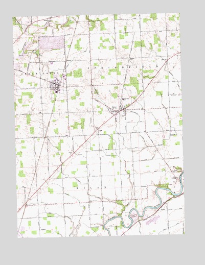
Grabill, IN USGS Topographic Map
Click on map above to begin viewing in our Map Viewer.

This topographic map contains these locations and features:
Feature Name Type Latitude Longitude GNIS ID View Map
Amstutz DitchCanalN41.1825°W84.9380°430148View Map
Barnett CemeteryCemeteryN41.1723°W84.9575°430509View Map
Boger DitchCanalN41.2473°W84.9425°431291View Map
Bottern DitchCanalN41.1534°W84.9461°431374View Map
Bull RapidsRapidsN41.1560°W84.8772°431792View Map
Bull Rapids BridgeBridgeN41.1564°W84.8772°431793View Map
CubaPopulated PlaceN41.1856°W84.9386°433233View Map
GrabillPopulated PlaceN41.2109°W84.9669°435251View Map
Grice DitchCanalN41.1375°W84.9680°435491View Map
Haifley DitchCanalN41.2262°W84.9550°435592View Map
Harding DitchCanalN41.1253°W84.9961°435729View Map
HarlanPopulated PlaceN41.1962°W84.9197°435737View Map
Harlan Census Designated PlaceCensusN41.1965°W84.9245°2629852View Map
HurshPopulated PlaceN41.2481°W84.9741°436653View Map
Hurshtown BridgeBridgeN41.2464°W84.9727°446919View Map
Hurshtown BridgeBridgeN41.2462°W84.9730°436654View Map
Hurshtown ReservoirReservoirN41.2282°W84.9796°448558View Map
Hurshtown Reservoir DamDamN41.2284°W84.9800°448559View Map
Kurtz DitchCanalN41.1603°W84.9455°437479View Map
Marsh DitchCanalN41.1292°W84.8841°438654View Map
Milan CenterPopulated PlaceN41.1442°W84.9461°439133View Map
Northeast Allen County Fire and Emergency Medical ServicesBuildingN41.2050°W84.9057°2625746View Map
Northeast Allen County Fire Department and Emergency Medical ServicesBuildingN41.2135°W84.9723°2626070View Map
Oberhaltzer DitchCanalN41.2078°W84.9400°440493View Map
Platter BridgeBridgeN41.1309°W84.9352°446918View Map
Reichelderfer DitchCanalN41.1939°W84.9094°441883View Map
Roth DitchCanalN41.1848°W84.9775°442335View Map
Salem ChurchChurchN41.2248°W84.9125°442898View Map
Shumacher DitchCanalN41.1284°W84.8755°443467View Map
Smith-Fry DitchCanalN41.2120°W84.8780°443705View Map
Town of GrabillCivilN41.2099°W84.9681°2396967View Map
Township of MilanCivilN41.1379°W84.9463°453624View Map
Township of SpringfieldCivilN41.2261°W84.9037°453864View Map
Turkey Run AirportAirportN41.1255°W84.9925°2676866View Map
Ward Lake DitchCanalN41.1674°W84.8984°2612632View Map
Wertz DitchCanalN41.2128°W84.8927°445686View Map
Wilbur DitchCanalN41.1670°W84.9186°446011View Map
Witmer DitchCanalN41.2184°W84.9733°446219View Map
Yaggy CemeteryCemeteryN41.1953°W84.9798°446360View Map
Zion SchoolSchoolN41.1562°W84.8794°446479View Map

Note: Coordinates in the location and feature list above are referenced to NAD83 datum.


Copyright (C) 2008-2025 Ryan Niemi / Sunset Dynamics ... All Rights Reserved