TopoQuest Logo
Do you find TopoQuest useful?
Help keep TopoQuest running and adding new maps/features by donating!
Bitcoin:  19c7KJd3qBynnjoSw5npx9KScwjBe4ifkT
Litecoin:  LXs6TkuXGGXo1vDsWCkWVdjQX94eUKd6ui
Home View Maps Find Maps Find Places Resources & Links


Woodward Island, California Topographic Map

USGS Map Title: Woodward Island, CA
USGS Map MRC: 37121H5
DRG (GeoTIFF) Download: o37121h5.tif


Neighboring USGS Topographic Map Quads:


  Jersey Island, CA  
38121A6
 

  Bouldin Island, CA  
38121A5
 

  Terminous, CA  
38121A4
 

  Brentwood, CA  
37121H6
 

  Woodward Island, CA  
37121H5
 

  Holt, CA  
37121H4
 

  Byron Hot Springs, CA  
37121G6
 

  Clifton Court Forebay, CA  
37121G5
 

  Union Island, CA  
37121G4


Map MRC Location:

N38°
W122°
N38°
W121°
H8 H7 H6 H5 H4 H3 H2 H1
G8 G7 G6 G5 G4 G3 G2 G1
F8 F7 F6 F5 F4 F3 F2 F1
E8 E7 E6 E5 E4 E3 E2 E1
D8 D7 D6 D5 D4 D3 D2 D1
C8 C7 C6 C5 C4 C3 C2 C1
B8 B7 B6 B5 B4 B3 B2 B1
A8 A7 A6 A5 A4 A3 A2 A1
N37°
W122°
N37°
W121°

Woodward Island, CA USGS 1:24K Topographic Map Preview:
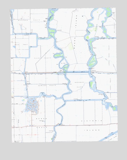
Woodward Island, CA USGS Topographic Map
Click on map above to begin viewing in our Map Viewer.

This topographic map contains these locations and features:
Feature Name Type Latitude Longitude GNIS ID View Map
Bacon IslandIslandN37.9766°W121.5522°218507View Map
BixlerPopulated PlaceN37.9402°W121.6222°1658066View Map
Byron California Discovery Bay Post OfficePost OfficeN37.8916°W121.6226°2650476View Map
Byron TractCivilN37.8874°W121.5908°220335View Map
Cabrillo BayBayN37.9105°W121.6041°1701745View Map
Contra Costa County Boys RanchLocaleN37.8752°W121.6216°221474View Map
Discovery BayPopulated PlaceN37.9085°W121.6002°1701762View Map
Discovery Bay Census Designated PlaceCensusN37.9064°W121.5985°2408672View Map
Discovery Bay Country ClubLocaleN37.8958°W121.5950°1701763View Map
Discovery Bay Elementary SchoolSchoolN37.9011°W121.5992°1701764View Map
East Contra Costa Fire Protection District Station 58BuildingN37.9035°W121.6018°2623955View Map
East Contra Costa Fire Protection District Station 59BuildingN37.9122°W121.6225°2623957View Map
Empire CutGutN37.9716°W121.5016°223195View Map
Fay IslandIslandN37.9485°W121.5652°223420View Map
Hayes SloughStreamN37.9391°W121.5011°225057View Map
Holland TractCivilN37.9985°W121.6022°225451View Map
Holman Slough (historical)GutN37.9858°W121.5733°1653182View Map
Indian SloughGutN37.9180°W121.5825°225900View Map
Kellogg CreekStreamN37.9069°W121.6094°226463View Map
Las Serpientes AirportAirportN37.9365°W121.6124°2650961View Map
Latham SloughGutN37.9869°W121.5144°226923View Map
Lido BayBayN37.9060°W121.6027°1701784View Map
Mansion House Ranch (historical)LocaleN37.9119°W121.5613°1653183View Map
Marina BayBayN37.9077°W121.6052°1701793View Map
Middle RiverLocaleN37.9410°W121.5319°228617View Map
Mildred IslandIslandN37.9863°W121.5230°228648View Map
Mildred Island FerryLocaleN37.9719°W121.5219°228649View Map
North CanalCanalN37.8796°W121.5102°234364View Map
North Victoria CanalCanalN37.9133°W121.5425°229774View Map
OrwoodPopulated PlaceN37.9399°W121.5688°252758View Map
Orwood TractCivilN37.9283°W121.5833°230129View Map
Palm TractCivilN37.9538°W121.5894°230260View Map
Rindge SchoolSchoolN37.9433°W121.5311°231613View Map
Rock SloughStreamN37.9755°W121.5808°231742View Map
Saint Marys BayBayN37.9208°W121.5894°232209View Map
Sand BayBayN37.9041°W121.6075°1701820View Map
TrullPopulated PlaceN37.9385°W121.5016°1660035View Map
Veale TractCivilN37.9663°W121.6225°237040View Map
Victoria CanalCanalN37.8808°W121.5105°237069View Map
Victoria IslandIslandN37.8899°W121.5347°237071View Map
WernerPopulated PlaceN37.9405°W121.6091°1660145View Map
Werner Dredger CutCanalN37.9313°W121.6086°237420View Map
Willow LakeReservoirN37.9085°W121.5969°1701831View Map
Woodward CanalCanalN37.9138°W121.5419°238173View Map
Woodward IslandIslandN37.9283°W121.5461°238174View Map
Woodward Island FerryLocaleN37.9199°W121.5169°238175View Map
Woodward RanchLocaleN37.9383°W121.5600°1653185View Map
Youngs SloughGutN37.9969°W121.5505°238288View Map

Note: Coordinates in the location and feature list above are referenced to NAD83 datum.


Copyright (C) 2008-2025 Ryan Niemi / Sunset Dynamics ... All Rights Reserved