TopoQuest Logo
Do you find TopoQuest useful?
Help keep TopoQuest running and adding new maps/features by donating!
Bitcoin:  19c7KJd3qBynnjoSw5npx9KScwjBe4ifkT
Litecoin:  LXs6TkuXGGXo1vDsWCkWVdjQX94eUKd6ui
Home View Maps Find Maps Find Places Resources & Links


Kaplan North, Louisiana Topographic Map

USGS Map Title: Kaplan North, LA
USGS Map MRC: 30092A3
DRG (GeoTIFF) Download: o30092a3.tif


Neighboring USGS Topographic Map Quads:


  Crowley West, LA  
30092B4
 

  Crowley East, LA  
30092B3
 

  Duson, LA  
30092B2
 

  Wright, LA  
30092A4
 

  Kaplan North, LA  
30092A3
 

  Leroy, LA  
30092A2


  Abbeville West, LA  
29092H2


Map MRC Location:

N31°
W93°
N31°
W92°
H8 H7 H6 H5 H4 H3 H2 H1
G8 G7 G6 G5 G4 G3 G2 G1
F8 F7 F6 F5 F4 F3 F2 F1
E8 E7 E6 E5 E4 E3 E2 E1
D8 D7 D6 D5 D4 D3 D2 D1
C8 C7 C6 C5 C4 C3 C2 C1
B8 B7 B6 B5 B4 B3 B2 B1
A8 A7 A6 A5 A4 A3 A2 A1
N30°
W93°
N30°
W92°

Kaplan North, LA USGS 1:24K Topographic Map Preview:
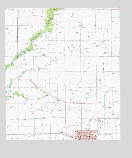
Kaplan North, LA USGS Topographic Map
Click on map above to begin viewing in our Map Viewer.

This topographic map contains these locations and features:
Feature Name Type Latitude Longitude GNIS ID View Map
Abrom Kaplan Memorial HospitalHospitalN30.0080°W92.2971°544172View Map
Abrom Kaplan Memorial Hospital HeliportAirportN30.0335°W92.2971°1632785View Map
Abshire CemeteryCemeteryN30.0983°W92.3376°532070View Map
Abshire Landing StripAirportN30.0830°W92.2676°544173View Map
Church of Christ in KaplanChurchN30.0044°W92.2926°544182View Map
City of KaplanCivilN30.0060°W92.2839°2404817View Map
Coles IslandAreaN30.0397°W92.3601°558913View Map
CossinadePopulated PlaceN30.0391°W92.3187°544184View Map
Cossinade CemeteryCemeteryN30.0410°W92.3182°544185View Map
Cossinade Gas FieldOilfieldN30.0402°W92.2726°544186View Map
Cossinade School (historical)SchoolN30.0410°W92.3190°544187View Map
Crossinade CemeteryCemeteryN30.0413°W92.3182°534287View Map
Faith Christian ChurchChurchN30.0062°W92.3050°2601622View Map
Hanks Airport (historical)AirportN30.0169°W92.3196°1632781View Map
Holy Rosary Catholic ChurchChurchN30.0044°W92.2874°544216View Map
Holy Rosary CemeteryCemeteryN30.0105°W92.2843°535760View Map
Hunter CanalCanalN30.0788°W92.2868°535863View Map
KAJN-FM (Crowley)TowerN30.0388°W92.3710°1633049View Map
Kaplan Baptist ChurchChurchN30.0038°W92.2937°544226View Map
Kaplan City Marshal's OfficeBuildingN30.0021°W92.2835°2334002View Map
Kaplan Elementary SchoolSchoolN30.0078°W92.2993°544227View Map
Kaplan Fire DepartmentBuildingN30.0018°W92.2837°2332372View Map
Kaplan Gas FieldOilfieldN30.0130°W92.3212°544228View Map
Kaplan Healthcare CenterBuildingN30.0086°W92.2964°2601050View Map
Kaplan Police DepartmentBuildingN30.0012°W92.2840°2334172View Map
Kaplan Post OfficePost OfficeN30.0005°W92.2854°1630072View Map
Kaplan United Methodist ChurchChurchN30.0024°W92.2860°544230View Map
KATC-TV (Lafayette)TowerN30.0388°W92.3710°1633128View Map
KLPB-TV (Lafayette)TowerN30.0441°W92.3707°1633131View Map
Le Musee de la Ville de KaplanBuildingN30.0011°W92.2841°2603225View Map
Leland Store (historical)LocaleN30.1085°W92.3621°544723View Map
LeleuxPopulated PlaceN30.0685°W92.3610°555019View Map
Lelieux Oil and Gas FieldOilfieldN30.0805°W92.3271°555020View Map
Liner ParkParkN30.0063°W92.2979°544235View Map
Lyons Point Volunteer Fire DepartmentBuildingN30.0946°W92.3611°2691669View Map
Maltrait Memorial Catholic SchoolSchoolN30.0044°W92.2882°544239View Map
Meaux Landing StripAirportN30.0471°W92.2835°544245View Map
Mire CemeteryCemeteryN30.0321°W92.2685°537158View Map
Parish Governing Authority District 10CivilN30.0038°W92.3525°1929791View Map
Parish Governing Authority District 12CivilN30.0521°W92.2909°1929832View Map
Rene A Rost Middle SchoolSchoolN30.0034°W92.2840°544268View Map
Saint Francis Cabrini Catholic ChurchChurchN30.0052°W92.2793°544274View Map
Shiloh Baptist ChurchChurchN30.0024°W92.2812°544285View Map
Simon BridgeBridgeN30.1144°W92.3235°539387View Map
Stroud SchoolSchoolN30.0049°W92.2796°544297View Map
Vermilion Parish Library Kaplan BranchBuildingN30.0050°W92.2824°2603167View Map
Vincent CanalCanalN30.0152°W92.2932°544310View Map
Ward FiveCivilN30.0938°W92.2671°545242View Map
Ward NineCivilN30.0072°W92.2890°545246View Map
Wills Landing StripAirportN30.0899°W92.3440°557073View Map

Note: Coordinates in the location and feature list above are referenced to NAD83 datum.


Copyright (C) 2008-2024 Ryan Niemi / Sunset Dynamics ... All Rights Reserved