TopoQuest Logo
Do you find TopoQuest useful?
Help keep TopoQuest running and adding new maps/features by donating!
Bitcoin:  19c7KJd3qBynnjoSw5npx9KScwjBe4ifkT
Litecoin:  LXs6TkuXGGXo1vDsWCkWVdjQX94eUKd6ui
Home View Maps Find Maps Find Places Resources & Links


Wrightsville, Georgia Topographic Map

USGS Map Title: Wrightsville, GA
USGS Map MRC: 32082F6
DRG (GeoTIFF) Download: o32082f6.tif


Neighboring USGS Topographic Map Quads:


  Irwins Crossroads, GA  
32082G7
 

  Harrison, GA  
32082G6
 

  Davisboro SE, GA  
32082G5
 

  Lovett, GA  
32082F7
 

  Wrightsville, GA  
32082F6
 

  Kite, GA  
32082F5
 

  East Dublin, GA  
32082E7
 

  Scott, GA  
32082E6
 

  Adrian, GA  
32082E5


Map MRC Location:

N33°
W83°
N33°
W82°
H8 H7 H6 H5 H4 H3 H2 H1
G8 G7 G6 G5 G4 G3 G2 G1
F8 F7 F6 F5 F4 F3 F2 F1
E8 E7 E6 E5 E4 E3 E2 E1
D8 D7 D6 D5 D4 D3 D2 D1
C8 C7 C6 C5 C4 C3 C2 C1
B8 B7 B6 B5 B4 B3 B2 B1
A8 A7 A6 A5 A4 A3 A2 A1
N32°
W83°
N32°
W82°

Wrightsville, GA USGS 1:24K Topographic Map Preview:
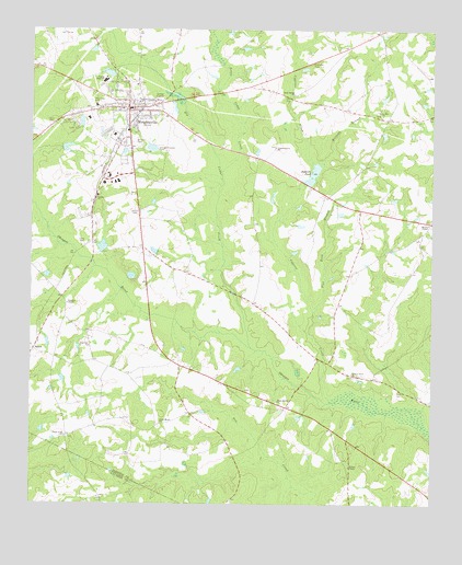
Wrightsville, GA USGS Topographic Map
Click on map above to begin viewing in our Map Viewer.

This topographic map contains these locations and features:
Feature Name Type Latitude Longitude GNIS ID View Map
Antioch Baptist ChurchChurchN32.7313°W82.7137°346653View Map
Bell PondReservoirN32.7257°W82.7343°341649View Map
Bell Pond DamDamN32.7252°W82.7349°341648View Map
Big Cedar CreekStreamN32.6641°W82.6721°311353View Map
Brachley CemeteryCemeteryN32.6777°W82.7385°346656View Map
Brantley ChapelChurchN32.6779°W82.7387°354838View Map
Browns Memorial Baptist ChurchChurchN32.7282°W82.7174°346657View Map
Camp ReedLocaleN32.6932°W82.7340°312249View Map
City of WrightsvilleCivilN32.7265°W82.7197°2405795View Map
Cypress CreekStreamN32.6521°W82.6560°313243View Map
Cypress Grove ChurchChurchN32.7191°W82.6740°313246View Map
Dailey Grove ChurchChurchN32.6968°W82.7026°346659View Map
East PondReservoirN32.6851°W82.7187°336345View Map
East Pond DamDamN32.6868°W82.7199°336344View Map
Flat Rock BranchStreamN32.6757°W82.6618°314192View Map
Galilee ChurchChurchN32.7054°W82.7301°314487View Map
Johnson CountyCivilN32.7015°W82.6601°346664View Map
Johnson County CourthouseBuildingN32.7299°W82.7190°346665View Map
Johnson County High SchoolSchoolN32.7365°W82.7274°346666View Map
Johnson County JailBuildingN32.7432°W82.7027°346667View Map
Johnson County Sheriff's DepartmentBuildingN32.7430°W82.7034°2733874View Map
Johnson State PrisonBuildingN32.7429°W82.7035°2735723View Map
Liberty Grove ChurchChurchN32.6596°W82.6496°316826View Map
Little Cedar CreekStreamN32.7127°W82.6904°316989View Map
Lord PondReservoirN32.6929°W82.7278°341644View Map
Lord Pond DamDamN32.6935°W82.7265°341643View Map
Luck LakeReservoirN32.7181°W82.7383°341646View Map
Luck Lake DamDamN32.7185°W82.7399°341645View Map
Maple Spring ChurchChurchN32.6521°W82.6726°317677View Map
Moores ChapelChurchN32.6988°W82.6260°318446View Map
Neelys ChapelChurchN32.7254°W82.7179°346670View Map
Pine Hill ChurchChurchN32.6666°W82.7315°320599View Map
Piney Mount ChurchChurchN32.6466°W82.7093°320732View Map
Piney Mount Fire DepartmentBuildingN32.6386°W82.6951°2604655View Map
Rock Spring ChurchChurchN32.7332°W82.6682°321751View Map
Rolands PondReservoirN32.7121°W82.6620°321880View Map
Shurling DamDamN32.7385°W82.7249°336346View Map
Shurling LakeReservoirN32.7386°W82.7260°336347View Map
Snell CemeteryCemeteryN32.6549°W82.6354°323189View Map
SpannPopulated PlaceN32.6657°W82.7487°333096View Map
Union Grove ChurchChurchN32.6429°W82.7387°324547View Map
Union Hill ChurchChurchN32.7277°W82.6404°324568View Map
Walker ChapelChurchN32.6349°W82.6501°324774View Map
West View CemeteryCemeteryN32.7313°W82.7318°325078View Map
Wildcat BranchStreamN32.7110°W82.6615°325266View Map
WIML-FM (Wrightsville)TowerN32.7068°W82.7187°352828View Map
WrightsvillePopulated PlaceN32.7293°W82.7199°325586View Map
Wrightsville Airport (historical)AirportN32.6557°W82.6957°351962View Map
Wrightsville City HallBuildingN32.7291°W82.7182°346674View Map
Wrightsville DivisionCivilN32.7348°W82.6656°1936660View Map
Wrightsville Elementary SchoolSchoolN32.7266°W82.7324°346675View Map
Wrightsville Fire DepartmentBuildingN32.7283°W82.7178°2603585View Map
Wrightsville Police DepartmentBuildingN32.7287°W82.7288°2733745View Map
Wrightsville Post OfficePost OfficeN32.7288°W82.7196°346676View Map
Wrightsville Primary SchoolSchoolN32.7224°W82.7243°346677View Map
Wrightsville Sewage Disposal PondReservoirN32.7189°W82.7125°341647View Map

Note: Coordinates in the location and feature list above are referenced to NAD83 datum.


Copyright (C) 2008-2025 Ryan Niemi / Sunset Dynamics ... All Rights Reserved