TopoQuest Logo
Do you find TopoQuest useful?
Help keep TopoQuest running and adding new maps/features by donating!
Bitcoin:  19c7KJd3qBynnjoSw5npx9KScwjBe4ifkT
Litecoin:  LXs6TkuXGGXo1vDsWCkWVdjQX94eUKd6ui
Home View Maps Find Maps Find Places Resources & Links


East Dublin, Georgia Topographic Map

USGS Map Title: East Dublin, GA
USGS Map MRC: 32082E7
DRG (GeoTIFF) Download: o32082e7.tif


Neighboring USGS Topographic Map Quads:


  Cow Hell Swamp, GA  
32082F8
 

  Lovett, GA  
32082F7
 

  Wrightsville, GA  
32082F6
 

  Dublin, GA  
32082E8
 

  East Dublin, GA  
32082E7
 

  Scott, GA  
32082E6
 

  Rentz, GA  
32082D8
 

  Minter, GA  
32082D7
 

  Rockledge, GA  
32082D6


Map MRC Location:

N33°
W83°
N33°
W82°
H8 H7 H6 H5 H4 H3 H2 H1
G8 G7 G6 G5 G4 G3 G2 G1
F8 F7 F6 F5 F4 F3 F2 F1
E8 E7 E6 E5 E4 E3 E2 E1
D8 D7 D6 D5 D4 D3 D2 D1
C8 C7 C6 C5 C4 C3 C2 C1
B8 B7 B6 B5 B4 B3 B2 B1
A8 A7 A6 A5 A4 A3 A2 A1
N32°
W83°
N32°
W82°

East Dublin, GA USGS 1:24K Topographic Map Preview:
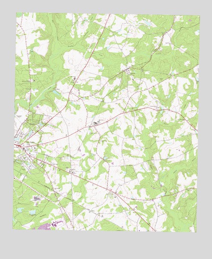
East Dublin, GA USGS Topographic Map
Click on map above to begin viewing in our Map Viewer.

This topographic map contains these locations and features:
Feature Name Type Latitude Longitude GNIS ID View Map
Bethlehem CemeteryCemeteryN32.5354°W82.8368°346491View Map
Bethlehem ChurchChurchN32.5352°W82.8360°354671View Map
Big CreekStreamN32.5704°W82.8749°311361View Map
BrewtonPopulated PlaceN32.5938°W82.7979°354848View Map
Brewton CemeteryCemeteryN32.5899°W82.7954°346497View Map
Brewton CreekStreamN32.6013°W82.8465°354849View Map
Brewton Post OfficePost OfficeN32.5929°W82.7985°1705305View Map
Brinkley LakeReservoirN32.6200°W82.7850°341248View Map
Brinkley Lake DamDamN32.6185°W82.7832°341247View Map
Brown Grove ChurchChurchN32.5802°W82.8643°354871View Map
CatlinPopulated PlaceN32.5113°W82.8218°326211View Map
City of East DublinCivilN32.5478°W82.8686°2403532View Map
CondorPopulated PlaceN32.5427°W82.8365°326230View Map
East DublinPopulated PlaceN32.5482°W82.8718°331618View Map
East Dublin Fire DepartmentBuildingN32.5476°W82.8714°2603806View Map
East Dublin Police DepartmentBuildingN32.5476°W82.8715°2733617View Map
East Laurens High SchoolSchoolN32.5624°W82.8193°313778View Map
East Laurens SchoolSchoolN32.5629°W82.8174°355600View Map
East Laurens SchoolSchoolN32.5877°W82.8346°355601View Map
Forest Hill ChurchChurchN32.5632°W82.8663°314268View Map
Fullers LandingLocaleN32.5007°W82.8746°346542View Map
Gethsemane CemeteryCemeteryN32.5521°W82.8151°314573View Map
Gethsemane ChurchChurchN32.5421°W82.8643°356005View Map
Graham Memorial ChurchChurchN32.5716°W82.7782°314763View Map
Hightower CreekStreamN32.6079°W82.8326°315402View Map
Indian BranchStreamN32.5213°W82.7704°315886View Map
Josey AcademySchoolN32.5335°W82.8346°316284View Map
Keen LakeReservoirN32.5884°W82.7510°341250View Map
Lakewood Development DamDamN32.5568°W82.8632°341253View Map
Lakewood Development LakeReservoirN32.5558°W82.8640°341254View Map
Laurens County Fire Department Station 7 Brewton - LovettBuildingN32.5929°W82.7982°2604498View Map
Laurens Memorial GardensCemeteryN32.5854°W82.8632°316685View Map
Lovett LakeReservoirN32.5796°W82.8477°341252View Map
Lovett Lake DamDamN32.5802°W82.8482°341251View Map
Manning (historical)Populated PlaceN32.6152°W82.7721°346578View Map
Mohasco Carpets DamDamN32.5102°W82.8615°341255View Map
Mohasco Carpets Industrial PondReservoirN32.5101°W82.8612°341256View Map
New Evergreen ChurchChurchN32.5649°W82.7590°319312View Map
Old CondorPopulated PlaceN32.5343°W82.8357°346599View Map
Reese Church (historical)ChurchN32.5438°W82.7512°346609View Map
Royal Springs ChurchChurchN32.5238°W82.8468°321980View Map
Shady Grove ChurchChurchN32.6088°W82.7693°322756View Map
Silver Leaf ChurchChurchN32.5249°W82.7562°322990View Map
Silver School (historical)SchoolN32.5252°W82.7562°346623View Map
Summer Store (historical)LocaleN32.6113°W82.8074°346629View Map
Warnock ParkParkN32.5352°W82.8663°324858View Map
Williams ChapelChurchN32.5379°W82.8490°325342View Map
WMLT-AM (Dublin)TowerN32.5641°W82.8665°352433View Map
WQZY-FM (Dublin)TowerN32.5643°W82.8715°352679View Map
Zion Hill ChurchChurchN32.5860°W82.8346°325696View Map

Note: Coordinates in the location and feature list above are referenced to NAD83 datum.


Copyright (C) 2008-2025 Ryan Niemi / Sunset Dynamics ... All Rights Reserved