TopoQuest Logo
Do you find TopoQuest useful?
Help keep TopoQuest running and adding new maps/features by donating!
Bitcoin:  19c7KJd3qBynnjoSw5npx9KScwjBe4ifkT
Litecoin:  LXs6TkuXGGXo1vDsWCkWVdjQX94eUKd6ui
Home View Maps Find Maps Find Places Resources & Links


Wyatt, Missouri Topographic Map

USGS Map Title: Wyatt, MO
USGS Map MRC: 36089H2
DRG (GeoTIFF) Download: o36089h2.tif


Neighboring USGS Topographic Map Quads:


  Cache, IL  
37089A3
 

  Cairo, IL  
37089A2
 

  Barlow, KY  
37089A1
 

  Charleston, MO  
36089H3
 

  Wyatt, MO  
36089H2
 

  Wickliffe, KY  
36089H1
 

  Anniston, MO  
36089G3
 

  Wickliffe SW, MO  
36089G2
 

  Arlington, KY  
36089G1


Map MRC Location:

N37°
W90°
N37°
W89°
H8 H7 H6 H5 H4 H3 H2 H1
G8 G7 G6 G5 G4 G3 G2 G1
F8 F7 F6 F5 F4 F3 F2 F1
E8 E7 E6 E5 E4 E3 E2 E1
D8 D7 D6 D5 D4 D3 D2 D1
C8 C7 C6 C5 C4 C3 C2 C1
B8 B7 B6 B5 B4 B3 B2 B1
A8 A7 A6 A5 A4 A3 A2 A1
N36°
W90°
N36°
W89°

Wyatt, MO USGS 1:24K Topographic Map Preview:
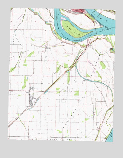
Wyatt, MO USGS Topographic Map
Click on map above to begin viewing in our Map Viewer.

This topographic map contains these locations and features:
Feature Name Type Latitude Longitude GNIS ID View Map
Alfalfa CenterPopulated PlaceN36.9631°W89.2073°739973View Map
Allen CemeteryCemeteryN36.9163°W89.1591°713212View Map
Angelo TowheadIslandN36.9795°W89.1753°403526View Map
Bayou DitchCanalN36.9206°W89.2140°754328View Map
Bird CemeteryCemeteryN36.9723°W89.1967°714260View Map
Bird Mill School (historical)SchoolN36.9664°W89.1795°754325View Map
Birds PointPopulated PlaceN36.9659°W89.1565°714265View Map
Birds Point School (historical)SchoolN36.9651°W89.1590°754324View Map
Brewer LakeLakeN36.9320°W89.1490°714675View Map
Brewer Lake DitchCanalN36.9039°W89.1453°714676View Map
Cairo PointCapeN36.9909°W89.1651°1736134View Map
Church of the RedeemerChurchN36.9995°W89.1667°1866726View Map
City of WyattCivilN36.9305°W89.1941°2397384View Map
Deans Blue HoleLakeN36.9867°W89.2067°716774View Map
Dry BayouStreamN36.9462°W89.1892°754323View Map
First Central Missionary Baptist ChurchChurchN36.9998°W89.1731°1866731View Map
First Missionary Baptist ChurchChurchN36.9998°W89.1715°1866734View Map
First United Methodist ChurchChurchN36.9984°W89.1690°1866737View Map
Fort Defiance State ParkParkN36.9864°W89.1459°408548View Map
GreenfieldPopulated PlaceN36.9651°W89.1717°730312View Map
Greenfield Bend Revetment (historical)LeveeN36.9720°W89.1862°754326View Map
Griggs CemeteryCemeteryN36.9141°W89.1815°718879View Map
Hoen Slough (historical)SwampN36.8820°W89.1465°754320View Map
Lateral Number 1CanalN36.8781°W89.2076°755456View Map
Little Rush Wood School (historical)SchoolN36.8923°W89.1842°754321View Map
Minor SloughGutN36.9987°W89.1270°514027View Map
Norfolk School District Number 6SchoolN36.9203°W89.1401°755457View Map
Ohio RiverStreamN36.9867°W89.1306°425264View Map
Otter PondLakeN36.9928°W89.2154°754327View Map
RodneyLocaleN36.9573°W89.2348°740083View Map
Rush Ridge CemeteryCemeteryN36.9221°W89.1840°2776798View Map
Rush Ridge ChurchChurchN36.9228°W89.1823°725675View Map
Rush Ridge SchoolSchoolN36.9234°W89.1806°754322View Map
Rushs RidgePopulated PlaceN36.9289°W89.1792°730311View Map
Saint Patricks Roman Catholic ChurchChurchN36.9998°W89.1687°1866753View Map
Saint Patricks SchoolSchoolN36.9998°W89.1687°1866754View Map
Saint Paul Baptist ChurchChurchN36.9995°W89.1737°1866755View Map
Stevenson BayouStreamN36.9901°W89.1979°727087View Map
Tom Bird Blue HoleLakeN36.9624°W89.1271°727701View Map
Township of OhioCivilN36.9308°W89.1842°767026View Map
Village of Wilson CityCivilN36.9236°W89.2230°2399708View Map
Washington SchoolSchoolN36.9187°W89.2256°728376View Map
Wilson CityPopulated PlaceN36.9226°W89.2240°728967View Map
WyattPopulated PlaceN36.9092°W89.2226°731670View Map
Wyatt CemeteryCemeteryN36.9072°W89.2256°2776799View Map
Wyatt Post OfficePost OfficeN36.9093°W89.2236°2783079View Map
Wyatt Volunteer Fire DepartmentBuildingN36.9090°W89.2240°2621232View Map

Note: Coordinates in the location and feature list above are referenced to NAD83 datum.


Copyright (C) 2008-2024 Ryan Niemi / Sunset Dynamics ... All Rights Reserved