TopoQuest Logo
Do you find TopoQuest useful?
Help keep TopoQuest running and adding new maps/features by donating!
Bitcoin:  19c7KJd3qBynnjoSw5npx9KScwjBe4ifkT
Litecoin:  LXs6TkuXGGXo1vDsWCkWVdjQX94eUKd6ui
Home View Maps Find Maps Find Places Resources & Links


Charleston, Missouri Topographic Map

USGS Map Title: Charleston, MO
USGS Map MRC: 36089H3
DRG (GeoTIFF) Download: o36089h3.tif


Neighboring USGS Topographic Map Quads:


  Thebes SW, MO  
37089A4
 

  Cache, IL  
37089A3
 

  Cairo, IL  
37089A2
 

  Bertrand, MO  
36089H4
 

  Charleston, MO  
36089H3
 

  Wyatt, MO  
36089H2
 

  East Prairie, MO  
36089G4
 

  Anniston, MO  
36089G3
 

  Wickliffe SW, MO  
36089G2


Map MRC Location:

N37°
W90°
N37°
W89°
H8 H7 H6 H5 H4 H3 H2 H1
G8 G7 G6 G5 G4 G3 G2 G1
F8 F7 F6 F5 F4 F3 F2 F1
E8 E7 E6 E5 E4 E3 E2 E1
D8 D7 D6 D5 D4 D3 D2 D1
C8 C7 C6 C5 C4 C3 C2 C1
B8 B7 B6 B5 B4 B3 B2 B1
A8 A7 A6 A5 A4 A3 A2 A1
N36°
W90°
N36°
W89°

Charleston, MO USGS 1:24K Topographic Map Preview:
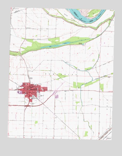
Charleston, MO USGS Topographic Map
Click on map above to begin viewing in our Map Viewer.

This topographic map contains these locations and features:
Feature Name Type Latitude Longitude GNIS ID View Map
Bethlehem ChurchChurchN36.9214°W89.2987°714092View Map
Big LakeLakeN36.9639°W89.3187°714185View Map
Big Lake DitchCanalN36.9751°W89.2684°714189View Map
Big Lake School (historical)SchoolN36.9895°W89.2584°747731View Map
Big Lake School (historical)SchoolN36.9826°W89.2581°747732View Map
Browns BarBarN36.9951°W89.2781°424680View Map
CatalpaPopulated PlaceN36.8828°W89.2945°739882View Map
CharlestonPopulated PlaceN36.9209°W89.3506°715743View Map
Charleston PlazaLocaleN36.9198°W89.3190°736100View Map
Charleston Police DepartmentBuildingN36.9251°W89.3497°2621767View Map
Charleston Post OfficePost OfficeN36.9219°W89.3496°2782823View Map
City of CharlestonCivilN36.9179°W89.3344°2393804View Map
Concord School (historical)SchoolN36.8776°W89.3292°747757View Map
CoulterPopulated PlaceN36.8859°W89.2526°739887View Map
CrenshawLocaleN36.9087°W89.3342°740333View Map
Dog Tooth BendBendN36.9884°W89.2795°739883View Map
Eugene Field SchoolSchoolN36.9226°W89.3409°717645View Map
Fish LakeLakeN36.9409°W89.2851°717943View Map
Fish Lake School (historical)SchoolN36.9406°W89.2906°730310View Map
Grigsby SchoolSchoolN36.9114°W89.2973°747734View Map
Grigsby School (historical)SchoolN36.9220°W89.2984°747733View Map
Hallett (historical)Populated PlaceN36.9003°W89.3223°739881View Map
HoughPopulated PlaceN36.9456°W89.2670°739885View Map
Independent Order of Odd Fellows CemeteryCemeteryN36.9401°W89.3514°2702463View Map
James Bayou (historical)StreamN36.9056°W89.2876°739886View Map
KCHR-AM (Charleston)TowerN36.9251°W89.2959°754289View Map
Lee CemeteryCemeteryN36.8954°W89.3167°720882View Map
Lincoln SchoolSchoolN36.9176°W89.3554°721084View Map
Mark Twan SchoolSchoolN36.9264°W89.3551°721881View Map
McDowell-Schmid Airport (historical)AirportN36.8959°W89.3656°758636View Map
Mississippi County Sheriff's OfficeBuildingN36.9239°W89.3520°2752518View Map
O'Rourkes Blue HoleLakeN36.9664°W89.2879°723551View Map
Rumsey Spur (historical)Populated PlaceN36.9501°W89.2562°739884View Map
Saint Francis de Dales ChurchChurchN36.9812°W89.3562°730308View Map
Saint Henrys SchoolSchoolN36.9242°W89.3473°726982View Map
Saint Mattews ChurchChurchN36.9481°W89.3081°726983View Map
Sliding TowheadIslandN36.9923°W89.3054°726551View Map
Southeast Correctional CenterBuildingN36.8951°W89.3508°2735661View Map
Sweet Home Church (historical)ChurchN36.9062°W89.2523°747735View Map
Texas BendPopulated PlaceN36.9801°W89.3565°730309View Map
Texas Bend CemeteryCemeteryN36.9806°W89.3567°735879View Map
Texas Bend SchoolSchoolN36.9806°W89.3473°747730View Map
Texas Bend School (historical)SchoolN36.9801°W89.3345°747729View Map
Township of TywappityCivilN36.9348°W89.3167°767028View Map
Upper Big Lake DamDamN36.9551°W89.3667°765587View Map
Warren E Hearnes SchoolSchoolN36.9134°W89.3476°728361View Map
Wolf HoleCanalN36.9017°W89.3473°729059View Map

Note: Coordinates in the location and feature list above are referenced to NAD83 datum.


Copyright (C) 2008-2024 Ryan Niemi / Sunset Dynamics ... All Rights Reserved