TopoQuest Logo
Do you find TopoQuest useful?
Help keep TopoQuest running and adding new maps/features by donating!
Bitcoin:  19c7KJd3qBynnjoSw5npx9KScwjBe4ifkT
Litecoin:  LXs6TkuXGGXo1vDsWCkWVdjQX94eUKd6ui
Home View Maps Find Maps Find Places Resources & Links


Zion Grove, North Carolina Topographic Map

USGS Map Title: Zion Grove, NC
USGS Map MRC: 35079C5
DRG (GeoTIFF) Download: o35079c5.tif


Neighboring USGS Topographic Map Quads:


  Spies, NC  
35079D6
 

  Robbins, NC  
35079D5
 

  Putnam, NC  
35079D4
 

  Candor, NC  
35079C6
 

  Zion Grove, NC  
35079C5
 

  Carthage, NC  
35079C4
 

  Norman, NC  
35079B6
 

  West End, NC  
35079B5
 

  Southern Pines, NC  
35079B4


Map MRC Location:

N36°
W80°
N36°
W79°
H8 H7 H6 H5 H4 H3 H2 H1
G8 G7 G6 G5 G4 G3 G2 G1
F8 F7 F6 F5 F4 F3 F2 F1
E8 E7 E6 E5 E4 E3 E2 E1
D8 D7 D6 D5 D4 D3 D2 D1
C8 C7 C6 C5 C4 C3 C2 C1
B8 B7 B6 B5 B4 B3 B2 B1
A8 A7 A6 A5 A4 A3 A2 A1
N35°
W80°
N35°
W79°

Zion Grove, NC USGS 1:24K Topographic Map Preview:
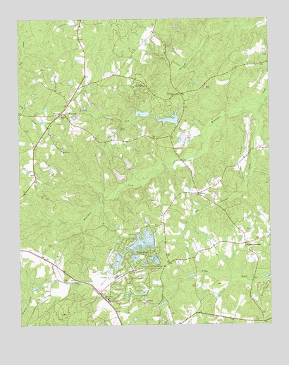
Zion Grove, NC USGS Topographic Map
Click on map above to begin viewing in our Map Viewer.

This topographic map contains these locations and features:
Feature Name Type Latitude Longitude GNIS ID View Map
Big Juniper CreekStreamN35.3379°W79.5050°981414View Map
Boy Scouts of America DamDamN35.3335°W79.5448°998817View Map
Boy Scouts of America DamDamN35.3368°W79.5598°998826View Map
Cedar Grove ChurchChurchN35.2610°W79.5823°982841View Map
Creek Grove ChurchChurchN35.3215°W79.6034°983735View Map
D C Ewing DamDamN35.2718°W79.5814°998714View Map
HarrisPopulated PlaceN35.3038°W79.5353°986440View Map
Love Grove ChurchChurchN35.2593°W79.5623°989054View Map
Moore County Emergency Medical Services Base 3BuildingN35.2710°W79.5731°2720475View Map
Mount Carmel ChurchChurchN35.3440°W79.5467°990350View Map
Occoneechee Scout ReservationLocaleN35.3482°W79.5667°991510View Map
Scott CemeteryCemeteryN35.3471°W79.5314°994426View Map
Seven LakesPopulated PlaceN35.2785°W79.5645°1022547View Map
Seven Lakes Airport (historical)AirportN35.2757°W79.5792°997904View Map
Seven Lakes Census Designated PlaceCensusN35.2647°W79.5865°2402839View Map
Seven Lakes Dam Number FiveDamN35.2752°W79.5581°998716View Map
Seven Lakes Dam Number FourDamN35.2785°W79.5681°998730View Map
Seven Lakes Dam Number ThreeDamN35.2785°W79.5564°998727View Map
Seven Lakes Dam Number TwoDamN35.2835°W79.5581°998740View Map
Seven Lakes Emergency Medical ServicesBuildingN35.2711°W79.5728°2720554View Map
Seven Lakes Lake Number FiveReservoirN35.2752°W79.5581°998715View Map
Seven Lakes Lake Number FourReservoirN35.2774°W79.5674°998729View Map
Seven Lakes Lake Number ThreeReservoirN35.2767°W79.5574°998728View Map
Seven Lakes Lake Number TwoReservoirN35.2840°W79.5634°998739View Map
Seven Lakes Number OneReservoirN35.2762°W79.5762°998731View Map
Seven Lakes Number One DamDamN35.2785°W79.5748°998732View Map
Seven Lakes Volunteer Fire DepartmentBuildingN35.2710°W79.5732°2638190View Map
Suck CreekStreamN35.3307°W79.5309°995637View Map
Thomas CrossroadsPopulated PlaceN35.2832°W79.5123°996039View Map
West End SchoolSchoolN35.2607°W79.5811°997009View Map
Zion GrovePopulated PlaceN35.3365°W79.6023°1024420View Map

Note: Coordinates in the location and feature list above are referenced to NAD83 datum.


Copyright (C) 2008-2025 Ryan Niemi / Sunset Dynamics ... All Rights Reserved