TopoQuest Logo
Do you find TopoQuest useful?
Help keep TopoQuest running and adding new maps/features by donating!
Bitcoin:  19c7KJd3qBynnjoSw5npx9KScwjBe4ifkT
Litecoin:  LXs6TkuXGGXo1vDsWCkWVdjQX94eUKd6ui
Home View Maps Find Maps Find Places Resources & Links


Carthage, North Carolina Topographic Map

USGS Map Title: Carthage, NC
USGS Map MRC: 35079C4
DRG (GeoTIFF) Download: o35079c4.tif


Neighboring USGS Topographic Map Quads:


  Robbins, NC  
35079D5
 

  Putnam, NC  
35079D4
 

  White Hill, NC  
35079D3
 

  Zion Grove, NC  
35079C5
 

  Carthage, NC  
35079C4
 

  Vass, NC  
35079C3
 

  West End, NC  
35079B5
 

  Southern Pines, NC  
35079B4
 

  Niagara, NC  
35079B3


Map MRC Location:

N36°
W80°
N36°
W79°
H8 H7 H6 H5 H4 H3 H2 H1
G8 G7 G6 G5 G4 G3 G2 G1
F8 F7 F6 F5 F4 F3 F2 F1
E8 E7 E6 E5 E4 E3 E2 E1
D8 D7 D6 D5 D4 D3 D2 D1
C8 C7 C6 C5 C4 C3 C2 C1
B8 B7 B6 B5 B4 B3 B2 B1
A8 A7 A6 A5 A4 A3 A2 A1
N35°
W80°
N35°
W79°

Carthage, NC USGS 1:24K Topographic Map Preview:
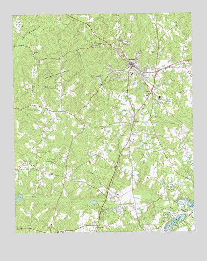
Carthage, NC USGS Topographic Map
Click on map above to begin viewing in our Map Viewer.

This topographic map contains these locations and features:
Feature Name Type Latitude Longitude GNIS ID View Map
Bethlehem ChurchChurchN35.3521°W79.4853°981209View Map
CarthagePopulated PlaceN35.3460°W79.4170°1019550View Map
Carthage Elementary SchoolSchoolN35.3410°W79.4164°1006738View Map
Carthage Lake Dam Number TwoDamN35.3285°W79.3797°998807View Map
Carthage Lake Number TwoReservoirN35.3296°W79.3793°998808View Map
Carthage Police DepartmentBuildingN35.3278°W79.4063°2769796View Map
Carthage Post OfficePost OfficeN35.3458°W79.4186°2773827View Map
Carthage Rescue SquadBuildingN35.3395°W79.4070°2720379View Map
Carthage Volunteer Fire DepartmentBuildingN35.3278°W79.4064°2638119View Map
Doubs ChapelChurchN35.2840°W79.4750°984298View Map
Eastwood Volunteer Fire DepartmentBuildingN35.2504°W79.4708°2638065View Map
Eureka ChurchChurchN35.2757°W79.3892°984848View Map
Fairview ChurchChurchN35.2910°W79.4909°984915View Map
Farm Life SchoolSchoolN35.2749°W79.3906°985005View Map
First Presbyterian ChurchChurchN35.3458°W79.4189°2465780View Map
Fly Rod LakeReservoirN35.2609°W79.3933°998685View Map
Fly Rod Lake DamDamN35.2618°W79.3931°998686View Map
Gilliam - Mc Connell AirfieldAirportN35.3423°W79.4376°2679130View Map
Goodwin State ForestForestN35.3424°W79.4670°985809View Map
Hill CrestPopulated PlaceN35.3135°W79.4164°1020774View Map
Ingram Branch ChurchChurchN35.2904°W79.4728°987381View Map
Killets CreekStreamN35.3721°W79.4464°987960View Map
Long Leaf LakeReservoirN35.2620°W79.4356°998687View Map
Long Leaf Lake DamDamN35.2618°W79.4348°998688View Map
Moore CountyCivilN35.3107°W79.4814°1008573View Map
Moore County Sheriff's OfficeBuildingN35.3432°W79.4187°2769638View Map
Mount Olive ChurchChurchN35.3571°W79.4431°990472View Map
Nicks CreekStreamN35.2652°W79.3984°991150View Map
Pine Lakes Shooting Preserve LakeReservoirN35.2701°W79.4978°998713View Map
PleasantvillePopulated PlaceN35.3196°W79.4661°992587View Map
Priest Hill ChurchChurchN35.3699°W79.3842°992817View Map
Saint Johns ChurchChurchN35.3577°W79.4406°993944View Map
Shadow LakeReservoirN35.2835°W79.4448°998737View Map
Shadow Lake DamDamN35.2835°W79.4448°998738View Map
Spring Valley LakeReservoirN35.2555°W79.3880°995361View Map
Spring Valley Lake DamDamN35.2552°W79.3898°998678View Map
Tobacco Road AirportAirportN35.2782°W79.3878°2679288View Map
Town of CarthageCivilN35.3224°W79.4116°2406227View Map
Township 1-CarthageCivilN35.3491°W79.4373°1026967View Map
Village of Whispering PinesCivilN35.2539°W79.3753°2407570View Map
Wads CreekStreamN35.2693°W79.4184°996667View Map
Whispering Pines Rescue SquadBuildingN35.2530°W79.3984°2720673View Map

Note: Coordinates in the location and feature list above are referenced to NAD83 datum.


Copyright (C) 2008-2025 Ryan Niemi / Sunset Dynamics ... All Rights Reserved