TopoQuest Logo
Do you find TopoQuest useful?
Help keep TopoQuest running and adding new maps/features by donating!
Bitcoin:  19c7KJd3qBynnjoSw5npx9KScwjBe4ifkT
Litecoin:  LXs6TkuXGGXo1vDsWCkWVdjQX94eUKd6ui
Home View Maps Find Maps Find Places Resources & Links


Zolfo Springs, Florida Topographic Map

USGS Map Title: Zolfo Springs, FL
USGS Map MRC: 27081D7
DRG (GeoTIFF) Download: o27081d7.tif


Neighboring USGS Topographic Map Quads:


  Fort Green, FL  
27081E8
 

  Wauchula, FL  
27081E7
 

  Griffins Corner, FL  
27081E6
 

  Ona, FL  
27081D8
 

  Zolfo Springs, FL  
27081D7
 

  Sweetwater, FL  
27081D6
 

  Limestone, FL  
27081C8
 

  Gardner, FL  
27081C7
 

  Crewsville SW, FL  
27081C6


Map MRC Location:

N28°
W82°
N28°
W81°
H8 H7 H6 H5 H4 H3 H2 H1
G8 G7 G6 G5 G4 G3 G2 G1
F8 F7 F6 F5 F4 F3 F2 F1
E8 E7 E6 E5 E4 E3 E2 E1
D8 D7 D6 D5 D4 D3 D2 D1
C8 C7 C6 C5 C4 C3 C2 C1
B8 B7 B6 B5 B4 B3 B2 B1
A8 A7 A6 A5 A4 A3 A2 A1
N27°
W82°
N27°
W81°

Zolfo Springs, FL USGS 1:24K Topographic Map Preview:
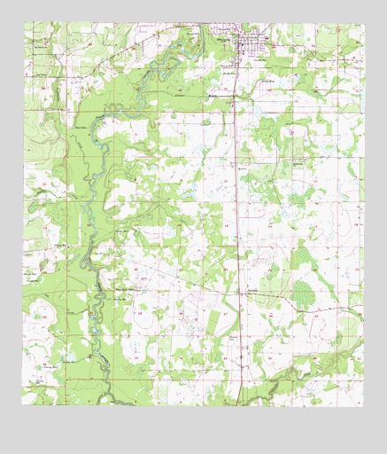
Zolfo Springs, FL USGS Topographic Map
Click on map above to begin viewing in our Map Viewer.

This topographic map contains these locations and features:
Feature Name Type Latitude Longitude GNIS ID View Map
Alligator BranchStreamN27.4753°W81.8315°277775View Map
BuchananPopulated PlaceN27.4120°W81.7926°294699View Map
Cantu ApiairiesLocaleN27.4989°W81.7781°2702358View Map
Crossroads Community ChurchChurchN27.4974°W81.7911°2452879View Map
First Baptist Church of Zolfo SpringsChurchN27.4951°W81.7931°2452880View Map
Friendship ChurchChurchN27.4556°W81.7754°282816View Map
Griffins Peace River Ranch AirportAirportN27.4196°W81.8331°309995View Map
Hardee CountyCivilN27.4927°W81.8099°295746View Map
Hardee County Fire Rescue Department Station 2BuildingN27.4947°W81.7968°2131473View Map
Hardee County Spanish United Methodist ChurchChurchN27.4972°W81.7872°2452881View Map
Hickory CreekStreamN27.4403°W81.8529°283951View Map
Johnson Trailer ParkPopulated PlaceN27.4873°W81.7565°2452876View Map
Limestone CreekStreamN27.3795°W81.8431°285538View Map
MoffittPopulated PlaceN27.4548°W81.7967°294855View Map
Mud LakeLakeN27.4658°W81.8558°287399View Map
Oak CreekStreamN27.4042°W81.8495°287926View Map
Oak GrovePopulated PlaceN27.4823°W81.8715°287931View Map
Oak Grove CemeteryCemeteryN27.4714°W81.8598°287936View Map
Oak Grove ChurchChurchN27.4917°W81.8720°287940View Map
Peace River RanchLocaleN27.4131°W81.8329°288612View Map
Sunshine Trailer ParkPopulated PlaceN27.4989°W81.8138°2452684View Map
The Oasis at Zolfo Springs Mobile Home ParkPopulated PlaceN27.4942°W81.7857°2452877View Map
Town of Zolfo SpringsCivilN27.4926°W81.7870°2406930View Map
Troublesome CreekStreamN27.4467°W81.8501°292459View Map
Wekiva Golf ClubLocaleN27.4955°W81.8217°2452682View Map
Wyndmoor Community Golf CourseLocaleN27.3850°W81.7945°2452875View Map
Zolfo SpringsPopulated PlaceN27.4934°W81.7959°293628View Map
Zolfo Springs Elementary SchoolSchoolN27.4953°W81.7857°297857View Map
Zolfo Springs Police DepartmentBuildingN27.4947°W81.7966°2333689View Map
Zolfo Springs Post OfficePost OfficeN27.4961°W81.7959°2783447View Map

Note: Coordinates in the location and feature list above are referenced to NAD83 datum.


Copyright (C) 2008-2024 Ryan Niemi / Sunset Dynamics ... All Rights Reserved