TopoQuest Logo
Do you find TopoQuest useful?
Help keep TopoQuest running and adding new maps/features by donating!
Bitcoin:  19c7KJd3qBynnjoSw5npx9KScwjBe4ifkT
Litecoin:  LXs6TkuXGGXo1vDsWCkWVdjQX94eUKd6ui
Home View Maps Find Maps Find Places Resources & Links


Boyce, Louisiana Topographic Map

USGS Map Title: Boyce, LA
USGS Map MRC: 31092D6
DRG (GeoTIFF) Download: o31092d6.tif


Neighboring USGS Topographic Map Quads:


  Aloha, LA  
31092E7
 

  Colfax, LA  
31092E6
 

  Dry Prong, LA  
31092E5
 

  Lena, LA  
31092D7
 

  Boyce, LA  
31092D6
 

  Rock Hill, LA  
31092D5
 

  Jericho, LA  
31092C7
 

  Gardner, LA  
31092C6
 

  Rapides, LA  
31092C5


Map MRC Location:

N32°
W93°
N32°
W92°
H8 H7 H6 H5 H4 H3 H2 H1
G8 G7 G6 G5 G4 G3 G2 G1
F8 F7 F6 F5 F4 F3 F2 F1
E8 E7 E6 E5 E4 E3 E2 E1
D8 D7 D6 D5 D4 D3 D2 D1
C8 C7 C6 C5 C4 C3 C2 C1
B8 B7 B6 B5 B4 B3 B2 B1
A8 A7 A6 A5 A4 A3 A2 A1
N31°
W93°
N31°
W92°

Boyce, LA USGS 1:24K Topographic Map Preview:
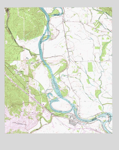
Boyce, LA USGS Topographic Map
Click on map above to begin viewing in our Map Viewer.

This topographic map contains these locations and features:
Feature Name Type Latitude Longitude GNIS ID View Map
Bayou DarrowStreamN31.4677°W92.6251°553447View Map
Bayou Jean De JeanStreamN31.3955°W92.6829°547019View Map
Bayou PatassaStreamN31.4099°W92.6426°553503View Map
Bayou TaureauStreamN31.4521°W92.6388°532788View Map
Big Mount Zion Baptist ChurchChurchN31.4935°W92.6810°533092View Map
Boggy BayouStreamN31.3893°W92.7090°533278View Map
BoycePopulated PlaceN31.3905°W92.6693°553764View Map
Boyce BranchStreamN31.3752°W92.7229°533350View Map
Boyce CemeteryCemeteryN31.3932°W92.6807°533351View Map
Boyce Elementary SchoolSchoolN31.3913°W92.6735°551676View Map
Boyce LakeSwampN31.3997°W92.6990°533352View Map
Boyce Police DepartmentBuildingN31.3904°W92.6697°2755265View Map
Boyce Volunteer Fire DepartmentBuildingN31.3906°W92.6702°2672910View Map
Bush LakeLakeN31.4349°W92.6971°553841View Map
Bush Lake (historical)LakeN31.4343°W92.6979°551679View Map
Bynum CemeteryCemeteryN31.4893°W92.6304°533602View Map
Cane River-Red Bayou Diversion CanalStreamN31.4535°W92.7090°555467View Map
Carnahan CreekStreamN31.4491°W92.7349°553899View Map
Castor LakeSwampN31.3824°W92.7465°553920View Map
Church of GodChurchN31.4146°W92.7218°551688View Map
Cotile Ward SevenCivilN31.3752°W92.7276°545174View Map
Davis CreekStreamN31.4810°W92.7468°554191View Map
Deloges BluffCliffN31.4463°W92.7060°534487View Map
Deloges CemeteryCemeteryN31.4463°W92.7118°534488View Map
FairmountPopulated PlaceN31.4377°W92.6776°545765View Map
Good Hope Baptist ChurchChurchN31.3860°W92.6657°554546View Map
Griffth CreekStreamN31.3877°W92.7124°551713View Map
Irish DitchStreamN31.3799°W92.7251°535945View Map
Israelite ChurchChurchN31.4180°W92.6707°535965View Map
KatelandPopulated PlaceN31.4563°W92.6757°554911View Map
Kateland Pond (historical)LakeN31.4618°W92.6785°545775View Map
Keystone Farms AirportAirportN31.4836°W92.6615°2770260View Map
Labourne BayouStreamN31.4282°W92.6632°554953View Map
Lacour CemeteryCemeteryN31.4432°W92.7049°536253View Map
Lake RodemacherReservoirN31.3858°W92.7459°555823View Map
Little Rock Baptist ChurchChurchN31.4593°W92.6763°536607View Map
Little Sandy BayouStreamN31.4043°W92.6379°536610View Map
Magnolia ChurchChurchN31.3910°W92.6799°536840View Map
McNeely Cut-OffChannelN31.4927°W92.7001°551739View Map
Mill PondLakeN31.4140°W92.6964°555322View Map
Mount Herman ChurchChurchN31.4266°W92.7251°555391View Map
Mount Olive School (historical)SchoolN31.4980°W92.7149°551741View Map
New Zion Baptist ChurchChurchN31.4471°W92.6318°537648View Map
Northwood High SchoolSchoolN31.4040°W92.7053°2462767View Map
OasisPopulated PlaceN31.4132°W92.7149°551749View Map
Parish Governing Authority District 3CivilN31.4687°W92.6635°1929953View Map
Pleasant ChurchChurchN31.4343°W92.7346°538234View Map
Pontfield BendBendN31.4030°W92.6960°545793View Map
Prospect ChurchChurchN31.4860°W92.6801°538416View Map
Raven Camp Baptist ChurchChurchN31.4724°W92.6782°538505View Map
Raven Camp School (historical)SchoolN31.4727°W92.6785°545799View Map
RavencampPopulated PlaceN31.4724°W92.6793°545800View Map
RockPopulated PlaceN31.4371°W92.7346°555816View Map
RodemacherPopulated PlaceN31.4185°W92.7224°551768View Map
Rose View CemeteryCemeteryN31.4352°W92.7332°538714View Map
Saint Aloysius CemeteryCemeteryN31.4299°W92.6863°538789View Map
Saint Mathias School (historical)SchoolN31.4463°W92.6685°545802View Map
Saint Matthias ChurchChurchN31.4463°W92.6690°539006View Map
Saint Paul Church (historical)ChurchN31.3852°W92.6999°551778View Map
Saint Thomas Church (historical)ChurchN31.3821°W92.6568°555950View Map
Sams BayouStreamN31.4955°W92.6351°539121View Map
Sandy BayouStreamN31.4399°W92.6404°539154View Map
Shagafoot LakeLakeN31.4452°W92.7218°556011View Map
Sneed CreekStreamN31.4593°W92.7268°556077View Map
Tabernacle Church (historical)ChurchN31.4313°W92.6682°545811View Map
Town of BoyceCivilN31.3906°W92.6699°2405308View Map
Union ChurchChurchN31.4524°W92.6260°540094View Map
Valentine CemeteryCemeteryN31.4979°W92.7279°540133View Map
Village Church (historical)ChurchN31.3946°W92.6596°545815View Map
Walnut Grove ChurchChurchN31.4866°W92.6776°540221View Map
Wettermark High SchoolSchoolN31.3868°W92.6749°551800View Map
White BranchStreamN31.3927°W92.7432°540358View Map
ZimmermanPopulated PlaceN31.4157°W92.7029°543803View Map
Zion Church (historical)ChurchN31.4552°W92.7160°551808View Map
Zion Harp Church (historical)ChurchN31.4724°W92.7076°551809View Map

Note: Coordinates in the location and feature list above are referenced to NAD83 datum.


Copyright (C) 2008-2025 Ryan Niemi / Sunset Dynamics ... All Rights Reserved