TopoQuest Logo
Do you find TopoQuest useful?
Help keep TopoQuest running and adding new maps/features by donating!
Bitcoin:  19c7KJd3qBynnjoSw5npx9KScwjBe4ifkT
Litecoin:  LXs6TkuXGGXo1vDsWCkWVdjQX94eUKd6ui
Home View Maps Find Maps Find Places Resources & Links


Rapides, Louisiana Topographic Map

USGS Map Title: Rapides, LA
USGS Map MRC: 31092C5
DRG (GeoTIFF) Download: o31092c5.tif


Neighboring USGS Topographic Map Quads:


  Boyce, LA  
31092D6
 

  Rock Hill, LA  
31092D5
 

  Ball, LA  
31092D4
 

  Gardner, LA  
31092C6
 

  Rapides, LA  
31092C5
 

  Alexandria, LA  
31092C4
 

  Elmer, LA  
31092B6
 

  Woodworth West, LA  
31092B5
 

  Woodworth East, LA  
31092B4


Map MRC Location:

N32°
W93°
N32°
W92°
H8 H7 H6 H5 H4 H3 H2 H1
G8 G7 G6 G5 G4 G3 G2 G1
F8 F7 F6 F5 F4 F3 F2 F1
E8 E7 E6 E5 E4 E3 E2 E1
D8 D7 D6 D5 D4 D3 D2 D1
C8 C7 C6 C5 C4 C3 C2 C1
B8 B7 B6 B5 B4 B3 B2 B1
A8 A7 A6 A5 A4 A3 A2 A1
N31°
W93°
N31°
W92°

Rapides, LA USGS 1:24K Topographic Map Preview:
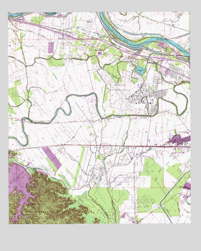
Rapides, LA USGS Topographic Map
Click on map above to begin viewing in our Map Viewer.

This topographic map contains these locations and features:
Feature Name Type Latitude Longitude GNIS ID View Map
Air Base Baptist ChurchChurchN31.3335°W92.5229°551810View Map
Air Base Road Baptist ChurchChurchN31.3338°W92.5226°553270View Map
Alexandria Country Day SchoolSchoolN31.3039°W92.5018°546959View Map
Alexandria International AirportAirportN31.3224°W92.5429°2676780View Map
AlfalfaPopulated PlaceN31.3696°W92.6185°546960View Map
BarrettPopulated PlaceN31.3671°W92.5135°546998View Map
Bayou BertrandStreamN31.3432°W92.6126°547006View Map
Bayou Rapides Medical CenterHospitalN31.2966°W92.5107°551668View Map
Belgard CemeteryCemeteryN31.2924°W92.6237°547051View Map
Big BayouStreamN31.3432°W92.6126°547070View Map
Briarwood HospitalHospitalN31.2946°W92.5051°551821View Map
Central Louisiana State HospitalHospitalN31.3130°W92.5290°547206View Map
Chandler AirportAirportN31.3106°W92.6139°1632592View Map
Clio Mill (historical)LocaleN31.3138°W92.5413°551691View Map
Community Baptist ChurchChurchN31.3366°W92.5074°551692View Map
Cooper School (historical)SchoolN31.3155°W92.5224°551694View Map
Crossroads Regional HospitalHospitalN31.2920°W92.5050°2674105View Map
Driftwood Trailer ParkPopulated PlaceN31.3293°W92.5249°551831View Map
England Air Force Base (historical)MilitaryN31.3269°W92.5408°2090305View Map
England Air Force Base Dependent SchoolSchoolN31.3230°W92.5260°551834View Map
First Bethlehem Baptist ChurchChurchN31.3155°W92.5224°551706View Map
First Evening Star Baptist ChurchChurchN31.3127°W92.5568°554404View Map
Flat BayouStreamN31.2799°W92.5576°547363View Map
Graham (historical)Populated PlaceN31.3071°W92.5607°551711View Map
Hope Baptist ChurchChurchN31.2952°W92.5385°554750View Map
Hope Baptist SchoolSchoolN31.2951°W92.5391°2462770View Map
Irish Ditch Number OneCanalN31.3527°W92.6151°547511View Map
Irish Ditch Number TwoCanalN31.3352°W92.5176°547512View Map
Kincaid (historical)Populated PlaceN31.2885°W92.6110°551725View Map
Kincaid BridgeBridgeN31.2830°W92.6068°547548View Map
Kincaid Reservoir DamDamN31.2835°W92.6146°556754View Map
Lamothe BridgeBridgeN31.3121°W92.6157°547561View Map
Lamotte CreekStreamN31.2716°W92.6151°547562View Map
Louisiana Youth AcademySchoolN31.2999°W92.5236°2462759View Map
Mabel Brasher Elementary SchoolSchoolN31.3003°W92.5143°551853View Map
Mack BranchStreamN31.2530°W92.6210°547640View Map
Methodonia ChurchChurchN31.3638°W92.5771°547685View Map
Myers Number 2 Landing StripAirportN31.3693°W92.5715°543818View Map
Newlight CemeteryCemeteryN31.3618°W92.5329°547776View Map
North Bayou Rapides Elementary SchoolSchoolN31.3329°W92.5095°1629735View Map
Olive ChurchChurchN31.3341°W92.5015°551752View Map
Parish Governing Authority District ICivilN31.3253°W92.5190°1930333View Map
Persimmon BayouStreamN31.2735°W92.5699°547830View Map
Pilgrim Rest ChurchChurchN31.3121°W92.6143°547837View Map
RapidesPopulated PlaceN31.3635°W92.5868°555753View Map
Rapides Baptist ChurchChurchN31.3557°W92.5713°551765View Map
Rapides ChurchChurchN31.3557°W92.5715°543817View Map
Rapides Golf and Country Club (historical)LocaleN31.3409°W92.5408°551867View Map
Rapides Parish ColiseumBuildingN31.2966°W92.5037°551868View Map
Rapides Parish Fire District 2 Station 4BuildingN31.3108°W92.5649°2673093View Map
Rapides Parish Sheriff's OfficeBuildingN31.3019°W92.5223°2755315View Map
Rapides SchoolSchoolN31.3110°W92.5660°547885View Map
Rapides Ward EightCivilN31.3199°W92.5196°545175View Map
Renaissance Home for YouthSchoolN31.3133°W92.5289°2462831View Map
Saint Mary's Day SchoolSchoolN31.3510°W92.5614°2462760View Map
Saint Mary's Residential Traning SchoolSchoolN31.3511°W92.5618°555923View Map
Saint Matthews Baptist ChurchChurchN31.3655°W92.5843°555926View Map
Saint Rita SchoolSchoolN31.3231°W92.5261°539070View Map
Saline BayouStreamN31.3130°W92.6107°547944View Map
Saline Lake (historical)LakeN31.3460°W92.6171°551779View Map
Sandy BayouStreamN31.3582°W92.5904°547958View Map
Tiger BayouStreamN31.2952°W92.5871°548082View Map
Turkey BayouStreamN31.2549°W92.5482°548094View Map
Valentine CreekStreamN31.2835°W92.6113°556317View Map
WeilPopulated PlaceN31.3118°W92.5607°548132View Map

Note: Coordinates in the location and feature list above are referenced to NAD83 datum.


Copyright (C) 2008-2024 Ryan Niemi / Sunset Dynamics ... All Rights Reserved