TopoQuest Logo
Do you find TopoQuest useful?
Help keep TopoQuest running and adding new maps/features by donating!
Bitcoin:  19c7KJd3qBynnjoSw5npx9KScwjBe4ifkT
Litecoin:  LXs6TkuXGGXo1vDsWCkWVdjQX94eUKd6ui
Home View Maps Find Maps Find Places Resources & Links


Bradford, Arkansas Topographic Map

USGS Map Title: Bradford, AR
USGS Map MRC: 35091D4
DRG (GeoTIFF) Download: o35091d4.tif


Neighboring USGS Topographic Map Quads:


  Huff, AR  
35091E5
 

  Olyphant, AR  
35091E4
 

  Newport, AR  
35091E3
 

  Velvet Ridge, AR  
35091D5
 

  Bradford, AR  
35091D4
 

  Augusta NE, AR  
35091D3
 

  Bald Knob, AR  
35091C5
 

  Augusta SW, AR  
35091C4
 

  Augusta, AR  
35091C3


Map MRC Location:

N36°
W92°
N36°
W91°
H8 H7 H6 H5 H4 H3 H2 H1
G8 G7 G6 G5 G4 G3 G2 G1
F8 F7 F6 F5 F4 F3 F2 F1
E8 E7 E6 E5 E4 E3 E2 E1
D8 D7 D6 D5 D4 D3 D2 D1
C8 C7 C6 C5 C4 C3 C2 C1
B8 B7 B6 B5 B4 B3 B2 B1
A8 A7 A6 A5 A4 A3 A2 A1
N35°
W92°
N35°
W91°

Bradford, AR USGS 1:24K Topographic Map Preview:
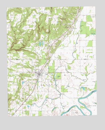
Bradford, AR USGS Topographic Map
Click on map above to begin viewing in our Map Viewer.

This topographic map contains these locations and features:
Feature Name Type Latitude Longitude GNIS ID View Map
Arm LakeLakeN35.4062°W91.3943°74630View Map
B C Smith Lake DamDamN35.3967°W91.4751°80945View Map
Bear Water SloughLakeN35.3845°W91.4236°46243View Map
Beaver LakeLakeN35.4079°W91.4167°74649View Map
Blackbird BendBendN35.3834°W91.4010°59298View Map
BradfordPopulated PlaceN35.4231°W91.4560°46885View Map
Bradford Elementary SchoolSchoolN35.4256°W91.4603°65044View Map
Bradford Fire DepartmentBuildingN35.4213°W91.4527°2116185View Map
Bradford High SchoolSchoolN35.4256°W91.4595°65045View Map
Bradford LakeLakeN35.4154°W91.4335°74694View Map
Bradford Police DepartmentBuildingN35.4248°W91.4559°2118627View Map
Bradford Volunteer Fire DepartmentBuildingN35.4245°W91.4608°2116186View Map
Bright LakeLakeN35.4682°W91.3775°74695View Map
Brown BendBendN35.3834°W91.3899°59301View Map
Brushy LakeLakeN35.3992°W91.4257°74711View Map
Butter CreekStreamN35.3884°W91.4604°47242View Map
Carter CemeteryCemeteryN35.3820°W91.4946°47494View Map
City of BradfordCivilN35.4223°W91.4557°2403909View Map
CoffeevillePopulated PlaceN35.4912°W91.4004°57563View Map
Coffeyville CemeteryCemeteryN35.4959°W91.3973°1890967View Map
Daniel LandingLocaleN35.3784°W91.4229°59304View Map
Dudley DreadBendN35.3806°W91.4154°59305View Map
Friendship ChurchChurchN35.4548°W91.4399°49265View Map
Goad Place (historical)LocaleN35.3931°W91.3987°59319View Map
Goose PondLakeN35.3831°W91.4355°74855View Map
Grand GlaisePopulated PlaceN35.4751°W91.4099°57837View Map
Grinnell PondLakeN35.4201°W91.4296°74867View Map
Heard CemeteryCemeteryN35.4259°W91.4804°49977View Map
Hickman BranchStreamN35.4456°W91.4504°50044View Map
Hickman CemeteryCemeteryN35.4595°W91.4518°50046View Map
Hopspinike LakeLakeN35.4154°W91.3951°74905View Map
Hopspinike SloughStreamN35.4262°W91.3751°50318View Map
Little LakeLakeN35.3931°W91.4476°74970View Map
Long BranchStreamN35.4198°W91.3893°51414View Map
Masons ReservoirReservoirN35.4579°W91.4538°80093View Map
Masons Reservoir DamDamN35.4567°W91.4535°80092View Map
McKnight CemeteryCemeteryN35.4248°W91.4960°51862View Map
Mica LakeLakeN35.4581°W91.4026°75020View Map
Oakland CemeteryCemeteryN35.4942°W91.4457°59267View Map
Oakland ChurchChurchN35.4934°W91.4457°52961View Map
Oats CreekStreamN35.4273°W91.4324°52975View Map
Old Grand GlaisePopulated PlaceN35.4898°W91.3754°77905View Map
Possum GrapePopulated PlaceN35.4759°W91.4112°58413View Map
Raleigh ReachChannelN35.3984°W91.3862°59311View Map
Russell PlaceLocaleN35.3773°W91.4276°59312View Map
Scantlin CemeteryCemeteryN35.4912°W91.4940°54610View Map
Smith LakeReservoirN35.3967°W91.4751°80946View Map
Smith Lake OneReservoirN35.4135°W91.4788°79760View Map
Smith Lake One DamDamN35.4151°W91.4785°79759View Map
Smith Lake TwoReservoirN35.3864°W91.4716°79762View Map
Smith Lake Two DamDamN35.3851°W91.4701°79761View Map
Steenbergen LakeLakeN35.4779°W91.3968°75143View Map
Township of GlaizeCivilN35.4845°W91.4105°66724View Map
Township of LibertyCivilN35.4125°W91.4509°69844View Map
Tucker RidgeRidgeN35.4365°W91.3796°55687View Map
Twin PondsSwampN35.4195°W91.4168°55757View Map

Note: Coordinates in the location and feature list above are referenced to NAD83 datum.


Copyright (C) 2008-2024 Ryan Niemi / Sunset Dynamics ... All Rights Reserved