TopoQuest Logo
Do you find TopoQuest useful?
Help keep TopoQuest running and adding new maps/features by donating!
Bitcoin:  19c7KJd3qBynnjoSw5npx9KScwjBe4ifkT
Litecoin:  LXs6TkuXGGXo1vDsWCkWVdjQX94eUKd6ui
Home View Maps Find Maps Find Places Resources & Links


Velvet Ridge, Arkansas Topographic Map

USGS Map Title: Velvet Ridge, AR
USGS Map MRC: 35091D5
DRG (GeoTIFF) Download: o35091d5.tif


Neighboring USGS Topographic Map Quads:


  Pleasant Plains, AR  
35091E6
 

  Huff, AR  
35091E5
 

  Olyphant, AR  
35091E4
 

  Steprock, AR  
35091D6
 

  Velvet Ridge, AR  
35091D5
 

  Bradford, AR  
35091D4
 

  Judsonia, AR  
35091C6
 

  Bald Knob, AR  
35091C5
 

  Augusta SW, AR  
35091C4


Map MRC Location:

N36°
W92°
N36°
W91°
H8 H7 H6 H5 H4 H3 H2 H1
G8 G7 G6 G5 G4 G3 G2 G1
F8 F7 F6 F5 F4 F3 F2 F1
E8 E7 E6 E5 E4 E3 E2 E1
D8 D7 D6 D5 D4 D3 D2 D1
C8 C7 C6 C5 C4 C3 C2 C1
B8 B7 B6 B5 B4 B3 B2 B1
A8 A7 A6 A5 A4 A3 A2 A1
N35°
W92°
N35°
W91°

Velvet Ridge, AR USGS 1:24K Topographic Map Preview:
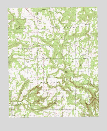
Velvet Ridge, AR USGS Topographic Map
Click on map above to begin viewing in our Map Viewer.

This topographic map contains these locations and features:
Feature Name Type Latitude Longitude GNIS ID View Map
Adelaide (historical)Populated PlaceN35.4954°W91.5301°61805View Map
Bethlehem CemeteryCemeteryN35.4756°W91.5824°46468View Map
Bliss (historical)Populated PlaceN35.4134°W91.6204°65043View Map
Boyce HillSummitN35.4170°W91.5415°57419View Map
Buddy LakeReservoirN35.4134°W91.6018°80948View Map
Buddy Lake DamDamN35.4134°W91.6018°80947View Map
Buzzard Roost MountainSummitN35.4031°W91.5154°57485View Map
Caplener BranchStreamN35.4404°W91.5354°47460View Map
Church of ChristChurchN35.4198°W91.5765°76613View Map
DenmarkPopulated PlaceN35.4842°W91.5832°57641View Map
Doctor Jacksons LakeReservoirN35.4701°W91.5535°80091View Map
Doctor Jacksons Lake DamDamN35.4701°W91.5535°80090View Map
Fussy BranchStreamN35.4595°W91.5526°49294View Map
HeffingtonPopulated PlaceN35.4495°W91.5132°57055View Map
Hurricane BranchStreamN35.4581°W91.5482°50430View Map
Mason HillSummitN35.4317°W91.5482°58131View Map
Morris CemeteryCemeteryN35.4831°W91.6246°52218View Map
Mount Carmel ChurchChurchN35.4801°W91.5126°52280View Map
Pine CreekStreamN35.3895°W91.6118°53410View Map
Plant CemeteryCemeteryN35.3770°W91.5010°53517View Map
Ranson LakeReservoirN35.4751°W91.6085°79771View Map
Ranson Lake DamDamN35.4751°W91.6085°79770View Map
Round MountainSummitN35.4348°W91.5412°58534View Map
Round MountainSummitN35.4801°W91.6137°54239View Map
Russell MountainSummitN35.3870°W91.5293°58561View Map
Short MountainSummitN35.4262°W91.5443°58623View Map
Smith CemeteryCemeteryN35.4459°W91.5210°54937View Map
Soapstone HillSummitN35.4320°W91.5246°58654View Map
Stevens CreekLocaleN35.3770°W91.6218°78460View Map
Sugar CreekStreamN35.4215°W91.5354°55298View Map
Throckmorton HillSummitN35.4540°W91.5665°58745View Map
Township of BarrenCivilN35.4850°W91.5313°66717View Map
Township of ColdwellCivilN35.3945°W91.6162°69823View Map
Township of DenmarkCivilN35.4866°W91.6149°69826View Map
Township of Velvet RidgeCivilN35.4138°W91.5668°69853View Map
TwentythreePopulated PlaceN35.3762°W91.5596°55754View Map
Velvet RidgePopulated PlaceN35.4131°W91.5762°55896View Map
Velvet Ridge CemeteryCemeteryN35.4201°W91.5729°55897View Map
Velvet Ridge Church of GodChurchN35.4129°W91.5762°65121View Map
Velvet Ridge Volunteer Fire DepartmentBuildingN35.4144°W91.5768°2117254View Map
Whippoorwill BranchStreamN35.4479°W91.5504°56233View Map
Wolf HollowValleyN35.3815°W91.5079°56494View Map

Note: Coordinates in the location and feature list above are referenced to NAD83 datum.


Copyright (C) 2008-2025 Ryan Niemi / Sunset Dynamics ... All Rights Reserved