TopoQuest Logo
Do you find TopoQuest useful?
Help keep TopoQuest running and adding new maps/features by donating!
Bitcoin:  19c7KJd3qBynnjoSw5npx9KScwjBe4ifkT
Litecoin:  LXs6TkuXGGXo1vDsWCkWVdjQX94eUKd6ui
Home View Maps Find Maps Find Places Resources & Links


Bald Knob, Arkansas Topographic Map

USGS Map Title: Bald Knob, AR
USGS Map MRC: 35091C5
DRG (GeoTIFF) Download: o35091c5.tif


Neighboring USGS Topographic Map Quads:


  Steprock, AR  
35091D6
 

  Velvet Ridge, AR  
35091D5
 

  Bradford, AR  
35091D4
 

  Judsonia, AR  
35091C6
 

  Bald Knob, AR  
35091C5
 

  Augusta SW, AR  
35091C4
 

  Kensett, AR  
35091B6
 

  West Point, AR  
35091B5
 

  Georgetown, AR  
35091B4


Map MRC Location:

N36°
W92°
N36°
W91°
H8 H7 H6 H5 H4 H3 H2 H1
G8 G7 G6 G5 G4 G3 G2 G1
F8 F7 F6 F5 F4 F3 F2 F1
E8 E7 E6 E5 E4 E3 E2 E1
D8 D7 D6 D5 D4 D3 D2 D1
C8 C7 C6 C5 C4 C3 C2 C1
B8 B7 B6 B5 B4 B3 B2 B1
A8 A7 A6 A5 A4 A3 A2 A1
N35°
W92°
N35°
W91°

Bald Knob, AR USGS 1:24K Topographic Map Preview:
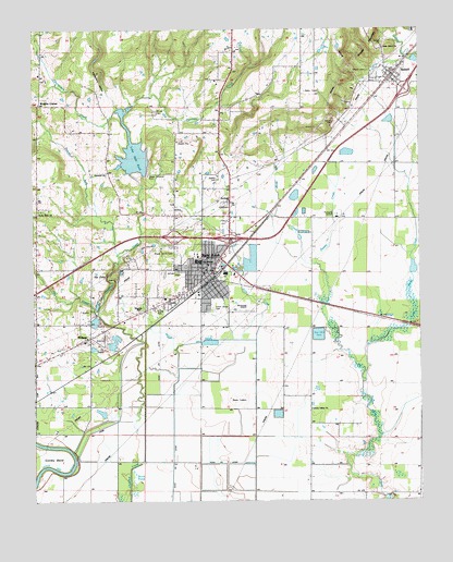
Bald Knob, AR USGS Topographic Map
Click on map above to begin viewing in our Map Viewer.

This topographic map contains these locations and features:
Feature Name Type Latitude Longitude GNIS ID View Map
Bald KnobPopulated PlaceN35.3098°W91.5679°76228View Map
Bald Knob Area AmbulanceBuildingN35.3176°W91.5633°2119125View Map
Bald Knob Church of ChristChurchN35.3118°W91.5701°66380View Map
Bald Knob High SchoolSchoolN35.3134°W91.5709°65033View Map
Bald Knob Middle SchoolSchoolN35.3140°W91.5724°2039119View Map
Bald Knob Municipal AirportAirportN35.2997°W91.5537°83632View Map
Bald Knob Police DepartmentBuildingN35.3173°W91.5628°2118625View Map
Bald Knob Post OfficePost OfficeN35.3112°W91.5671°84380View Map
Bald Knob Volunteer Fire Department Station 1BuildingN35.3063°W91.5733°2116105View Map
Bald Knob Volunteer Fire Department Station 2BuildingN35.3047°W91.5659°2116106View Map
Bald Knob Volunteer Fire Department Station 3BuildingN35.3174°W91.5634°2116107View Map
Bald Knob Wastewater Treatment PlantLocaleN35.2939°W91.5328°2416192View Map
Birch PondLakeN35.2543°W91.5910°70312View Map
Bolden CemeteryCemeteryN35.3351°W91.5648°46819View Map
Central Baptist ChurchChurchN35.3126°W91.5687°66381View Map
Chinquapin CreekStreamN35.3537°W91.5974°47757View Map
City of Bald KnobCivilN35.3122°W91.5705°2403148View Map
Conley BendBendN35.2606°W91.6182°47961View Map
First Christian ChurchChurchN35.3104°W91.5699°66382View Map
First United Methodist ChurchChurchN35.3115°W91.5676°66383View Map
Flat CreekStreamN35.2998°W91.6046°49103View Map
Gilbert CemeteryCemeteryN35.3640°W91.5162°49406View Map
Gladey CreekStreamN35.3126°W91.5335°49433View Map
Gum CreekStreamN35.2926°W91.5582°49707View Map
H L Lubker Elementary SchoolSchoolN35.3134°W91.5726°2039128View Map
H L Lubker Elementary SchoolSchoolN35.3131°W91.5710°65077View Map
Hopewell ChurchChurchN35.3368°W91.6010°77217View Map
Huckleberry HollowValleyN35.3545°W91.5971°50383View Map
Jesus Name ChurchChurchN35.3701°W91.5112°50643View Map
KAPZ-AM (Bald Knob)TowerN35.2756°W91.5610°85050View Map
Lake Bald KnobReservoirN35.3425°W91.5924°79776View Map
Lake Bald Knob DamDamN35.3368°W91.5901°79775View Map
Liberty ValleyPopulated PlaceN35.2776°W91.5357°65094View Map
Liberty Valley Missionary Baptist ChurchChurchN35.2740°W91.5351°77493View Map
Little Mingo CreekStreamN35.2840°W91.5179°51298View Map
MidwayPopulated PlaceN35.2929°W91.6079°58173View Map
Midway Baptist ChurchChurchN35.2931°W91.6085°65100View Map
Pleasant Grove Baptist ChurchChurchN35.3056°W91.5674°66384View Map
Pleasant Grove CemeteryCemeteryN35.3004°W91.5665°53530View Map
Powder ForkStreamN35.3154°W91.5976°53736View Map
Prince CemeteryCemeteryN35.3531°W91.5851°53805View Map
Reorganized Church of Jesus Christ of Latter Day SaintsChurchN35.3126°W91.5704°66385View Map
Rocky Point Baptist ChurchChurchN35.3262°W91.6235°78207View Map
Rocky Point Volunteer Fire DepartmentBuildingN35.3250°W91.6235°2117035View Map
RussellPopulated PlaceN35.3626°W91.5076°81894View Map
Russell Fire Department Station 1BuildingN35.3611°W91.5084°2117075View Map
Russell Fire Department Station 2BuildingN35.3629°W91.5110°2117076View Map
Russell Post OfficePost OfficeN35.3627°W91.5093°84976View Map
Shady Grove CemeteryCemeteryN35.3170°W91.5801°54691View Map
The CliffsCliffN35.3095°W91.6012°55509View Map
Town of RussellCivilN35.3620°W91.5100°2407258View Map
Township of Bald KnobCivilN35.2925°W91.5545°69815View Map
United States Fish and Wildlife Bald Knob National Wildlife Refuge Park SecurityBuildingN35.2758°W91.5711°2118622View Map
Wrights CornerPopulated PlaceN35.3554°W91.6229°57238View Map

Note: Coordinates in the location and feature list above are referenced to NAD83 datum.


Copyright (C) 2008-2024 Ryan Niemi / Sunset Dynamics ... All Rights Reserved