TopoQuest Logo
Do you find TopoQuest useful?
Help keep TopoQuest running and adding new maps/features by donating!
Bitcoin:  19c7KJd3qBynnjoSw5npx9KScwjBe4ifkT
Litecoin:  LXs6TkuXGGXo1vDsWCkWVdjQX94eUKd6ui
Home View Maps Find Maps Find Places Resources & Links


Bradford, Minnesota Topographic Map

USGS Map Title: Bradford, MN
USGS Map MRC: 45093E3
DRG (GeoTIFF) Download: o45093e3.tif


Neighboring USGS Topographic Map Quads:


  Dalbo, MN  
45093F4
 

  Springvale, MN  
45093F3
 

  Braham, MN  
45093F2
 

  Wyanett, MN  
45093E4
 

  Bradford, MN  
45093E3
 

  Cambridge, MN  
45093E2
 

  Crown, MN  
45093D4
 

  Saint Francis, MN  
45093D3
 

  Isanti, MN  
45093D2


Map MRC Location:

N46°
W94°
N46°
W93°
H8 H7 H6 H5 H4 H3 H2 H1
G8 G7 G6 G5 G4 G3 G2 G1
F8 F7 F6 F5 F4 F3 F2 F1
E8 E7 E6 E5 E4 E3 E2 E1
D8 D7 D6 D5 D4 D3 D2 D1
C8 C7 C6 C5 C4 C3 C2 C1
B8 B7 B6 B5 B4 B3 B2 B1
A8 A7 A6 A5 A4 A3 A2 A1
N45°
W94°
N45°
W93°

Bradford, MN USGS 1:24K Topographic Map Preview:
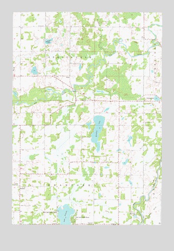
Bradford, MN USGS Topographic Map
Click on map above to begin viewing in our Map Viewer.

This topographic map contains these locations and features:
Feature Name Type Latitude Longitude GNIS ID View Map
Bar-L Ranch Country ClubLocaleN45.5064°W93.2713°659781View Map
Becklin Homestead Park Wildlife Management AreaParkN45.5986°W93.2750°2069235View Map
BradfordPopulated PlaceN45.5225°W93.3688°640415View Map
Bradford Post Office (historical)Post OfficeN45.6053°W93.3681°2069216View Map
Bradford SchoolSchoolN45.5230°W93.3733°640416View Map
Brobergs LakeLakeN45.5744°W93.2549°640491View Map
Calvary Baptist AcademySchoolN45.5750°W93.2533°2069263View Map
Calvary Baptist ChurchChurchN45.5750°W93.2533°2069264View Map
Cambridge Municipal AirportAirportN45.5585°W93.2646°660092View Map
Dowling SchoolSchoolN45.6169°W93.3494°642917View Map
East Lake Francis ShoresPopulated PlaceN45.5039°W93.3238°643088View Map
Elizabeth LakeLakeN45.5553°W93.3038°643254View Map
Isanti BrookStreamN45.5033°W93.2652°645471View Map
Isanti CountyCivilN45.5615°W93.2952°659475View Map
Kienitz CemeteryCemeteryN45.5008°W93.3072°646137View Map
Lake Elizabeth Game RefugeParkN45.5556°W93.3000°2069319View Map
Lake FrancisLakeN45.5057°W93.3307°643876View Map
Maywood County ParkParkN45.5631°W93.3389°2069320View Map
Saint Johns ChurchChurchN45.5005°W93.2888°650715View Map
Springvale County ParkParkN45.5958°W93.3569°2069322View Map
Stanchfield CreekStreamN45.6025°W93.2894°652541View Map
Township of BradfordCivilN45.5149°W93.3275°663646View Map
Township of SpringvaleCivilN45.6014°W93.3276°665680View Map
WalboPopulated PlaceN45.5872°W93.3269°654991View Map
Walbo Post Office (historical)Post OfficeN45.5872°W93.3267°2069199View Map
West Lake Francis ShoresPopulated PlaceN45.5077°W93.3375°653980View Map
Westbriar County ParkParkN45.5514°W93.2717°2069318View Map
Williams LakeLakeN45.6079°W93.3454°654168View Map

Note: Coordinates in the location and feature list above are referenced to NAD83 datum.


Copyright (C) 2008-2025 Ryan Niemi / Sunset Dynamics ... All Rights Reserved