TopoQuest Logo
Do you find TopoQuest useful?
Help keep TopoQuest running and adding new maps/features by donating!
Bitcoin:  19c7KJd3qBynnjoSw5npx9KScwjBe4ifkT
Litecoin:  LXs6TkuXGGXo1vDsWCkWVdjQX94eUKd6ui
Home View Maps Find Maps Find Places Resources & Links


Brady Butte, Oregon Topographic Map

USGS Map Title: Brady Butte, OR
USGS Map MRC: 42121A1
DRG (GeoTIFF) Download: o42121a1.tif


Neighboring USGS Topographic Map Quads:


  Goodlow Mountain, OR  
42121B2
 

  Gerber Reservoir, OR  
42121B1
 

  Barnes Valley, OR  
42120B8
 

  Langell Valley, OR  
42121A2
 

  Brady Butte, OR  
42121A1
 

  Antler Point, OR  
42120A8
 

  Carr Butte, CA  
41121H2
 

  Sagebrush Butte, CA  
41121H1
 

  Steele Swamp, CA  
41120H8


Map MRC Location:

N43°
W122°
N43°
W121°
H8 H7 H6 H5 H4 H3 H2 H1
G8 G7 G6 G5 G4 G3 G2 G1
F8 F7 F6 F5 F4 F3 F2 F1
E8 E7 E6 E5 E4 E3 E2 E1
D8 D7 D6 D5 D4 D3 D2 D1
C8 C7 C6 C5 C4 C3 C2 C1
B8 B7 B6 B5 B4 B3 B2 B1
A8 A7 A6 A5 A4 A3 A2 A1
N42°
W122°
N42°
W121°

Brady Butte, OR USGS 1:24K Topographic Map Preview:
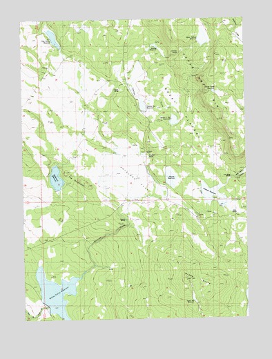
Brady Butte, OR USGS Topographic Map
Click on map above to begin viewing in our Map Viewer.

This topographic map contains these locations and features:
Feature Name Type Latitude Longitude GNIS ID View Map
Alkali SpringSpringN42.0431°W121.0068°1116867View Map
Antelope CreekStreamN42.0215°W121.0886°1132078View Map
Antelope DamDamN42.0482°W121.0211°1133450View Map
Antelope FlatFlatN42.0588°W121.0628°1116975View Map
Antelope RanchLocaleN42.0677°W121.0561°1116985View Map
Antelope ReservoirReservoirN42.0516°W121.0203°1116986View Map
Antelope Reservoir Day-Use AreaParkN42.0482°W121.0209°2572599View Map
Antelope SpringSpringN42.0677°W121.0553°1133089View Map
Bear Valley CanyonValleyN42.0546°W121.0175°1137761View Map
Brady ButteSummitN42.0157°W121.0358°1136091View Map
Bumphead DamDamN42.0543°W121.1065°1133473View Map
Bumphead ReservoirReservoirN42.0574°W121.1070°1118308View Map
Cold SpringSpringN42.0212°W121.0769°1157784View Map
Dog Hollow DamDamN42.1132°W121.1041°1131570View Map
Dog Hollow ReservoirReservoirN42.1173°W121.1076°1120012View Map
Duncan SpringSpringN42.0413°W121.0683°1120211View Map
Gerber Lower Division ReservoirReservoirN42.0826°W121.0410°1133091View Map
Horse Camp ReservoirReservoirN42.0942°W121.0180°1133093View Map
Horse Camp RimCliffN42.1002°W121.0272°1121987View Map
Jake Spring ReservoirReservoirN42.1001°W121.0643°1160560View Map
Jennette SpringSpringN42.1105°W121.0380°1122403View Map
Junction WaterholeReservoirN42.0207°W121.0178°1133086View Map
Kilgore DamDamN42.0560°W121.0450°1133573View Map
Kilgore ReservoirReservoirN42.0574°W121.0447°1122726View Map
Logger WaterholeReservoirN42.1235°W121.0264°1157786View Map
Lost River SpringSpringN42.0582°W121.0122°1133088View Map
Midway ReservoirReservoirN42.1137°W121.0509°1124134View Map
North SpringSpringN42.0955°W121.0741°1124843View Map
Rimrock SpringSpringN42.0763°W121.0136°1133090View Map
Rocky PlateauPlainN42.0871°W121.0414°1126243View Map
Spreader ReservoirReservoirN42.0915°W121.0836°1157785View Map
The BumpheadsSummitN42.0579°W121.0947°1127953View Map
Timber Hill ReservoirReservoirN42.0074°W121.0308°1133085View Map
Twenty One ReservoirReservoirN42.0885°W121.0580°1133092View Map
Upper Midway DamDamN42.1149°W121.0262°1131569View Map
Upper Midway ReservoirReservoirN42.1166°W121.0241°1128463View Map
Willow Valley Boat RampLocaleN42.0091°W121.1162°2700275View Map
Willow Valley CampgroundLocaleN42.0096°W121.1178°1133087View Map
Willow Valley DamDamN42.0059°W121.1134°1133723View Map
Willow Valley ReservoirReservoirN42.0111°W121.1085°1129179View Map

Note: Coordinates in the location and feature list above are referenced to NAD83 datum.


Copyright (C) 2008-2025 Ryan Niemi / Sunset Dynamics ... All Rights Reserved