TopoQuest Logo
Do you find TopoQuest useful?
Help keep TopoQuest running and adding new maps/features by donating!
Bitcoin:  19c7KJd3qBynnjoSw5npx9KScwjBe4ifkT
Litecoin:  LXs6TkuXGGXo1vDsWCkWVdjQX94eUKd6ui
Home View Maps Find Maps Find Places Resources & Links


Braggs, Oklahoma Topographic Map

USGS Map Title: Braggs, OK
USGS Map MRC: 35095F2
DRG (GeoTIFF) Download: o35095f2.tif


Neighboring USGS Topographic Map Quads:


  Northeast Muskogee, OK  
35095G3
 

  Fort Gibson Dam, OK  
35095G2
 

  Zeb, OK  
35095G1
 

  Southeast Muskogee, OK  
35095F3
 

  Braggs, OK  
35095F2
 

  Qualls, OK  
35095F1
 

  Keefton, OK  
35095E3
 

  Webbers Falls, OK  
35095E2
 

  Gore, OK  
35095E1


Map MRC Location:

N36°
W96°
N36°
W95°
H8 H7 H6 H5 H4 H3 H2 H1
G8 G7 G6 G5 G4 G3 G2 G1
F8 F7 F6 F5 F4 F3 F2 F1
E8 E7 E6 E5 E4 E3 E2 E1
D8 D7 D6 D5 D4 D3 D2 D1
C8 C7 C6 C5 C4 C3 C2 C1
B8 B7 B6 B5 B4 B3 B2 B1
A8 A7 A6 A5 A4 A3 A2 A1
N35°
W96°
N35°
W95°

Braggs, OK USGS 1:24K Topographic Map Preview:
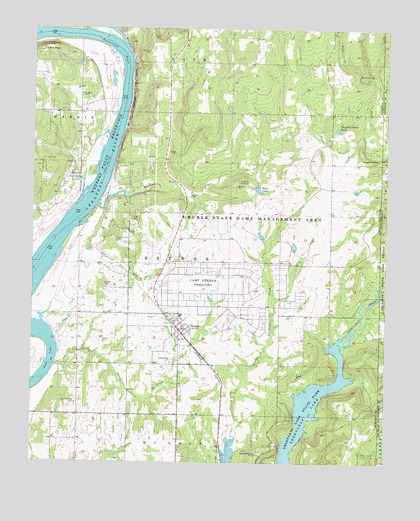
Braggs, OK USGS Topographic Map
Click on map above to begin viewing in our Map Viewer.

This topographic map contains these locations and features:
Feature Name Type Latitude Longitude GNIS ID View Map
Bayou ManardStreamN35.7493°W95.2316°1089894View Map
Bondinot CreekStreamN35.6993°W95.2272°1090391View Map
BraggsPopulated PlaceN35.6634°W95.1980°1090449View Map
Braggs Elementary SchoolSchoolN35.6673°W95.1979°1790571View Map
Braggs High SchoolSchoolN35.6673°W95.1979°1790273View Map
Braggs Police DepartmentBuildingN35.6638°W95.1982°2757782View Map
Braggs Post OfficePost OfficeN35.6658°W95.2001°1813322View Map
Braggs Volunteer Fire DepartmentBuildingN35.6635°W95.1976°2657173View Map
Camp GruberMilitaryN35.6736°W95.1803°2512059View Map
Camp GruberLocaleN35.6770°W95.1905°1090861View Map
Camp Gruber HeliportAirportN35.6737°W95.2055°1102378View Map
Devils PeakSummitN35.7445°W95.2450°1092062View Map
Gooseneck BendBendN35.7432°W95.2197°1093266View Map
Greenleaf LakeReservoirN35.6354°W95.1539°1093392View Map
Gruber State Game Management AreaParkN35.7040°W95.1566°1093432View Map
Harnage CemeteryCemeteryN35.7298°W95.2316°1093557View Map
Harris CemeteryCemeteryN35.7056°W95.2397°1093569View Map
Hopewell Park Public Use AreaParkN35.7073°W95.2352°1093920View Map
Joe BranchStreamN35.6982°W95.2250°1094232View Map
Little Deep Fork Creek Site 57b DamDamN35.7218°W95.2086°1751634View Map
Little Deep Fork Creek Site 57b ReservoirReservoirN35.7218°W95.2086°1751635View Map
Oknoname 101018 DamDamN35.6868°W95.1569°1755380View Map
Oknoname 101018 ReservoirReservoirN35.6876°W95.1579°1755381View Map
Oknoname 101019 DamDamN35.7034°W95.1352°1755382View Map
Oknoname 101019 ReservoirReservoirN35.7035°W95.1361°1755383View Map
Oknoname 101020 DamDamN35.6901°W95.1686°1755386View Map
Oknoname 101020 ReservoirReservoirN35.6908°W95.1697°1755387View Map
Oknoname 101021 DamDamN35.6718°W95.1869°1755390View Map
Oknoname 101021 ReservoirReservoirN35.6726°W95.1876°1755391View Map
Pumpkin CenterPopulated PlaceN35.7129°W95.1272°1100769View Map
Pumpkin Center PondReservoirN35.7214°W95.1427°1096957View Map
Pumpkin Center Pond DamDamN35.7218°W95.1419°1755384View Map
River BottomCivilN35.6358°W95.2379°2631160View Map
River Bottom Census Designated PlaceCensusN35.6358°W95.2379°2409182View Map
Salt CreekStreamN35.6626°W95.2408°1097678View Map
Sand CreekStreamN35.6529°W95.2419°1097738View Map
Sand HillCivilN35.6341°W95.2012°2631167View Map
Sand Hill Census Designated PlaceCensusN35.6341°W95.2012°2409268View Map
Sand Springs ChurchChurchN35.6540°W95.2011°1097786View Map
South Bethel CemeteryCemeteryN35.6420°W95.2344°1098207View Map
Star LakeLakeN35.6551°W95.2441°1098494View Map
Town of BraggsCivilN35.6632°W95.1984°2411718View Map
Township of BrewerCivilN35.6834°W95.1975°1824626View Map
Walker CemeteryCemeteryN35.6762°W95.2247°1099301View Map
WPA PondReservoirN35.7038°W95.1708°1755389View Map
WPA Pond DamDamN35.7034°W95.1702°1755388View Map

Note: Coordinates in the location and feature list above are referenced to NAD83 datum.


Copyright (C) 2008-2024 Ryan Niemi / Sunset Dynamics ... All Rights Reserved