TopoQuest Logo
Do you find TopoQuest useful?
Help keep TopoQuest running and adding new maps/features by donating!
Bitcoin:  19c7KJd3qBynnjoSw5npx9KScwjBe4ifkT
Litecoin:  LXs6TkuXGGXo1vDsWCkWVdjQX94eUKd6ui
Home View Maps Find Maps Find Places Resources & Links


Fort Gibson Dam, Oklahoma Topographic Map

USGS Map Title: Fort Gibson Dam, OK
USGS Map MRC: 35095G2
DRG (GeoTIFF) Download: o35095g2.tif


Neighboring USGS Topographic Map Quads:


  Wagoner East, OK  
35095H3
 

  Hulbert, OK  
35095H2
 

  Thompson Corner, OK  
35095H1
 

  Northeast Muskogee, OK  
35095G3
 

  Fort Gibson Dam, OK  
35095G2
 

  Zeb, OK  
35095G1
 

  Southeast Muskogee, OK  
35095F3
 

  Braggs, OK  
35095F2
 

  Qualls, OK  
35095F1


Map MRC Location:

N36°
W96°
N36°
W95°
H8 H7 H6 H5 H4 H3 H2 H1
G8 G7 G6 G5 G4 G3 G2 G1
F8 F7 F6 F5 F4 F3 F2 F1
E8 E7 E6 E5 E4 E3 E2 E1
D8 D7 D6 D5 D4 D3 D2 D1
C8 C7 C6 C5 C4 C3 C2 C1
B8 B7 B6 B5 B4 B3 B2 B1
A8 A7 A6 A5 A4 A3 A2 A1
N35°
W96°
N35°
W95°

Fort Gibson Dam, OK USGS 1:24K Topographic Map Preview:
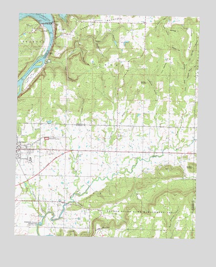
Fort Gibson Dam, OK USGS Topographic Map
Click on map above to begin viewing in our Map Viewer.

This topographic map contains these locations and features:
Feature Name Type Latitude Longitude GNIS ID View Map
Anderson CemeteryCemeteryN35.7948°W95.1663°1089621View Map
Andersons CemeteryCemeteryN35.8681°W95.1327°1089633View Map
Blackberry HillSummitN35.8668°W95.1408°1090214View Map
Boughtman HollowValleyN35.8600°W95.1974°1090416View Map
Braggs MountainSummitN35.7570°W95.1922°1090450View Map
Buzzard HollowValleyN35.8554°W95.1377°1090767View Map
Canyon Road Public Use AreaParkN35.8395°W95.2411°1090945View Map
Cedar HollowValleyN35.8722°W95.1500°1091122View Map
Dam Site Public Use AreaParkN35.8654°W95.2300°1091924View Map
Deadman HollowValleyN35.8551°W95.2097°1091975View Map
Dripping Spring HollowValleyN35.8398°W95.1336°1092193View Map
Flower CreekStreamN35.8470°W95.2319°1092905View Map
Fort Gibson Citizen's CemeteryCemeteryN35.7974°W95.2289°1092959View Map
Fort Gibson DamDamN35.8700°W95.2288°1092960View Map
Fort Gibson Early Learning CenterSchoolN35.7937°W95.2405°2713093View Map
Fort Gibson High SchoolSchoolN35.7923°W95.2404°1790334View Map
Fort Gibson Intermediate Elementary SchoolSchoolN35.7937°W95.2405°1790652View Map
Fort Gibson LakeReservoirN35.8695°W95.2305°1092961View Map
Fort Gibson Middle SchoolSchoolN35.7937°W95.2409°1790335View Map
Fort Gibson National CemeteryCemeteryN35.8048°W95.2291°1092962View Map
Four Mile CemeteryCemeteryN35.8103°W95.1758°2712539View Map
Fourmile BranchStreamN35.7840°W95.1869°1092989View Map
Fourmile Branch ChurchChurchN35.8076°W95.1800°1092990View Map
Fourteenmile CreekStreamN35.8732°W95.2355°1093002View Map
Hicks BranchStreamN35.8012°W95.1419°1093722View Map
Iron Spring HollowValleyN35.8473°W95.1341°1094122View Map
Kale Dick HollowValleyN35.8114°W95.1377°1094282View Map
Limestone HollowValleyN35.8078°W95.1526°1094654View Map
Lucy Albirdie FlatFlatN35.8493°W95.1469°1095044View Map
McGee HollowValleyN35.8643°W95.1858°1095237View Map
Norwood Elementary SchoolSchoolN35.8714°W95.1637°1096066View Map
Norwood Fire Department Station 1BuildingN35.8706°W95.1642°2656979View Map
Norwood Lakeview ChurchChurchN35.8712°W95.1983°1096064View Map
Runnels MountainSummitN35.8718°W95.1327°1097526View Map
Sleeper HollowValleyN35.7692°W95.2109°1098116View Map
Spurlop MountainSummitN35.8373°W95.1666°1098465View Map
Starnes CemeteryCemeteryN35.7995°W95.1566°1098500View Map
Sugar HollowValleyN35.8473°W95.2202°1098602View Map
Township of NashCivilN35.7695°W95.1975°1824623View Map
Walker BranchStreamN35.7740°W95.2091°1099298View Map
Walker CemeteryCemeteryN35.7937°W95.2144°1099299View Map
Whiskey HollowValleyN35.8142°W95.2059°1099674View Map

Note: Coordinates in the location and feature list above are referenced to NAD83 datum.


Copyright (C) 2008-2025 Ryan Niemi / Sunset Dynamics ... All Rights Reserved