TopoQuest Logo
Do you find TopoQuest useful?
Help keep TopoQuest running and adding new maps/features by donating!
Bitcoin:  19c7KJd3qBynnjoSw5npx9KScwjBe4ifkT
Litecoin:  LXs6TkuXGGXo1vDsWCkWVdjQX94eUKd6ui
Home View Maps Find Maps Find Places Resources & Links


Brazil West, Indiana Topographic Map

USGS Map Title: Brazil West, IN
USGS Map MRC: 39087E2
DRG (GeoTIFF) Download: o39087e2.tif


Neighboring USGS Topographic Map Quads:


  Mecca, IN  
39087F3
 

  Catlin, IN  
39087F2
 

  Mansfield, IN  
39087F1
 

  Rosedale, IN  
39087E3
 

  Brazil West, IN  
39087E2
 

  Brazil East, IN  
39087E1
 

  Seelyville, IN  
39087D3
 

  Staunton, IN  
39087D2
 

  Center Point, IN  
39087D1


Map MRC Location:

N40°
W88°
N40°
W87°
H8 H7 H6 H5 H4 H3 H2 H1
G8 G7 G6 G5 G4 G3 G2 G1
F8 F7 F6 F5 F4 F3 F2 F1
E8 E7 E6 E5 E4 E3 E2 E1
D8 D7 D6 D5 D4 D3 D2 D1
C8 C7 C6 C5 C4 C3 C2 C1
B8 B7 B6 B5 B4 B3 B2 B1
A8 A7 A6 A5 A4 A3 A2 A1
N39°
W88°
N39°
W87°

Brazil West, IN USGS 1:24K Topographic Map Preview:
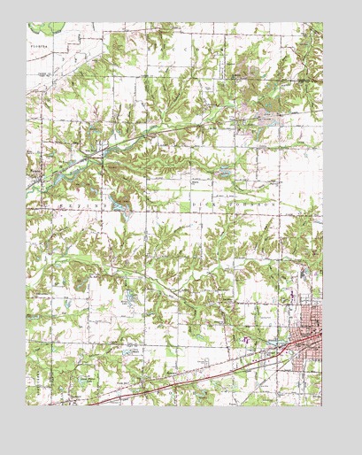
Brazil West, IN USGS Topographic Map
Click on map above to begin viewing in our Map Viewer.

This topographic map contains these locations and features:
Feature Name Type Latitude Longitude GNIS ID View Map
Aqua CreekStreamN39.5414°W87.1983°430228View Map
Archer CemeteryCemeteryN39.6035°W87.1723°430237View Map
Ash RunStreamN39.5437°W87.1467°430302View Map
Bee CreekStreamN39.5450°W87.1695°430705View Map
Bee RidgePopulated PlaceN39.5370°W87.1695°430706View Map
Bee Ridge SchoolSchoolN39.5339°W87.1645°430707View Map
Berea ChurchChurchN39.5039°W87.1439°430839View Map
BilltownPopulated PlaceN39.5100°W87.1861°431086View Map
Billtown CemeteryCemeteryN39.5085°W87.2000°431087View Map
BillvillePopulated PlaceN39.5037°W87.1256°431088View Map
Black RunStreamN39.5964°W87.1908°431143View Map
Blue BrookStreamN39.5856°W87.2117°431217View Map
BrazilPopulated PlaceN39.5237°W87.1250°431462View Map
Brazil City Fire DepartmentBuildingN39.5229°W87.1256°2625863View Map
Brazil Junior High SchoolSchoolN39.5273°W87.1272°446524View Map
Brazil Police DepartmentBuildingN39.5230°W87.1256°2758459View Map
Canaan ChurchChurchN39.5556°W87.1297°432095View Map
Carbon StreamStreamN39.6173°W87.1297°432125View Map
Carter CemeteryCemeteryN39.5703°W87.1964°432185View Map
Clago CreekStreamN39.5136°W87.2447°432542View Map
Clearview CemeteryCemeteryN39.5140°W87.1737°432635View Map
CloverlandPopulated PlaceN39.5014°W87.2314°432691View Map
Coal BluffPopulated PlaceN39.5828°W87.2200°449640View Map
Coal RunStreamN39.5459°W87.1481°432711View Map
CobbPopulated PlaceN39.5812°W87.2233°432716View Map
Cottage HillPopulated PlaceN39.5170°W87.1492°433013View Map
Cottage Hill CemeteryCemeteryN39.5187°W87.1520°433014View Map
Cottage RunStreamN39.5217°W87.1514°433015View Map
Cress CemeteryCemeteryN39.5997°W87.2415°433112View Map
Denman CemeteryCemeteryN39.6173°W87.2120°433471View Map
DiamondPopulated PlaceN39.6114°W87.1661°433527View Map
Diamond CreekStreamN39.5937°W87.1928°433528View Map
Dick Johnson Volunteer Fire DepartmentBuildingN39.5620°W87.1427°2625798View Map
Dick RunStreamN39.5475°W87.1470°433536View Map
Dive BranchStreamN39.5445°W87.2422°433573View Map
EhrmandalePopulated PlaceN39.5350°W87.2389°434047View Map
Fairview ChurchChurchN39.5728°W87.1436°434337View Map
Fairwood DrainStreamN39.5753°W87.1642°434355View Map
Flo RunStreamN39.6212°W87.2389°434606View Map
FontanetPopulated PlaceN39.5761°W87.2436°434631View Map
Fontanet Census Designated PlaceCensusN39.5713°W87.2434°2583452View Map
Gold RunStreamN39.5920°W87.1928°435153View Map
Green BrookStreamN39.5845°W87.2117°435388View Map
Harpold CemeteryCemeteryN39.5206°W87.2145°435768View Map
Harpold RunStreamN39.5164°W87.2175°435769View Map
Hendrix ParkParkN39.5325°W87.1300°436025View Map
Izaak Walton LakeReservoirN39.5080°W87.2264°448661View Map
Izaak Walton Lake DamDamN39.5084°W87.2284°448660View Map
Jackson SchoolSchoolN39.5198°W87.1361°436900View Map
Johnson RunStreamN39.5478°W87.1547°437066View Map
Kilns CreekStreamN39.5320°W87.1783°437302View Map
Landing RunStreamN39.5223°W87.1511°437604View Map
Little CreekStreamN39.5789°W87.2186°438028View Map
Meridian Street Elementary SchoolSchoolN39.5259°W87.1303°439020View Map
Morey LakeReservoirN39.5343°W87.2047°452068View Map
Nevins Township Volunteer Fire DepartmentBuildingN39.5742°W87.2432°2626160View Map
No BrookStreamN39.6037°W87.1445°440185View Map
No End CreekStreamN39.5289°W87.2425°440186View Map
Orchard CemeteryCemeteryN39.6048°W87.1336°440680View Map
Orchard RunStreamN39.6095°W87.1333°440688View Map
Otter Creek ChurchChurchN39.5414°W87.2233°440744View Map
Peniel ChurchChurchN39.5267°W87.1667°440991View Map
Peniel RunStreamN39.5250°W87.1620°440992View Map
PerthPopulated PlaceN39.5931°W87.1620°441045View Map
Perth CemeteryCemeteryN39.5904°W87.1615°441046View Map
Pinckey SchoolSchoolN39.5184°W87.1270°441147View Map
Pit RunStreamN39.5437°W87.2172°441200View Map
Purdy HillPopulated PlaceN39.5067°W87.2086°441666View Map
Purdy RunStreamN39.5098°W87.2017°441667View Map
Richer CemeteryCemeteryN39.5389°W87.2383°441954View Map
Rio Grande StreamStreamN39.5434°W87.2039°442054View Map
Rio West RunStreamN39.5478°W87.1967°442055View Map
Rock Run ChurchChurchN39.5973°W87.1736°442211View Map
Saint Marys CemeteryCemeteryN39.6046°W87.1664°442692View Map
Saint Marys ChurchChurchN39.6067°W87.1633°442702View Map
Sampson CemeteryCemeteryN39.5750°W87.1645°442952View Map
Shady LanePopulated PlaceN39.5456°W87.1336°443250View Map
Sharon BrookStreamN39.5787°W87.2175°443293View Map
Sharon ChurchChurchN39.5723°W87.1800°443298View Map
Spring LakeReservoirN39.5317°W87.2489°446554View Map
Stunkard CemeteryCemeteryN39.5464°W87.1347°444303View Map
Stunkard RunStreamN39.5478°W87.1378°444304View Map
Sullivan CemeteryCemeteryN39.5810°W87.2413°444365View Map
Swim BrookStreamN39.5464°W87.2375°444492View Map
Township of Dick JohnsonCivilN39.5658°W87.1653°453265View Map
Township of NevinsCivilN39.5642°W87.2473°453659View Map
Twin BeachPopulated PlaceN39.5181°W87.2050°445006View Map
Twin Beach LakeReservoirN39.5184°W87.2100°448658View Map
Twin Beach Lake DamDamN39.5174°W87.2092°448659View Map
Water Works LakeReservoirN39.5209°W87.1457°448755View Map
Water Works Lake DamDamN39.5217°W87.1483°448756View Map
Waterworks CreekStreamN39.5370°W87.1881°445546View Map
WBDJ-FM (Brazil)TowerN39.5120°W87.1386°448969View Map
Web RunStreamN39.6148°W87.2278°445609View Map
Webster CemeteryCemeteryN39.6122°W87.2190°445620View Map
Webster CreekStreamN39.6206°W87.2386°445622View Map
WickvillePopulated PlaceN39.5953°W87.1431°452221View Map
WWCM-AM (Brazil)TowerN39.5120°W87.1386°448455View Map

Note: Coordinates in the location and feature list above are referenced to NAD83 datum.


Copyright (C) 2008-2024 Ryan Niemi / Sunset Dynamics ... All Rights Reserved