TopoQuest Logo
Do you find TopoQuest useful?
Help keep TopoQuest running and adding new maps/features by donating!
Bitcoin:  19c7KJd3qBynnjoSw5npx9KScwjBe4ifkT
Litecoin:  LXs6TkuXGGXo1vDsWCkWVdjQX94eUKd6ui
Home View Maps Find Maps Find Places Resources & Links


Staunton, Indiana Topographic Map

USGS Map Title: Staunton, IN
USGS Map MRC: 39087D2
DRG (GeoTIFF) Download: o39087d2.tif


Neighboring USGS Topographic Map Quads:


  Rosedale, IN  
39087E3
 

  Brazil West, IN  
39087E2
 

  Brazil East, IN  
39087E1
 

  Seelyville, IN  
39087D3
 

  Staunton, IN  
39087D2
 

  Center Point, IN  
39087D1
 

  Lewis, IN  
39087C3
 

  Saline City, IN  
39087C2
 

  Clay City, IN  
39087C1


Map MRC Location:

N40°
W88°
N40°
W87°
H8 H7 H6 H5 H4 H3 H2 H1
G8 G7 G6 G5 G4 G3 G2 G1
F8 F7 F6 F5 F4 F3 F2 F1
E8 E7 E6 E5 E4 E3 E2 E1
D8 D7 D6 D5 D4 D3 D2 D1
C8 C7 C6 C5 C4 C3 C2 C1
B8 B7 B6 B5 B4 B3 B2 B1
A8 A7 A6 A5 A4 A3 A2 A1
N39°
W88°
N39°
W87°

Staunton, IN USGS 1:24K Topographic Map Preview:
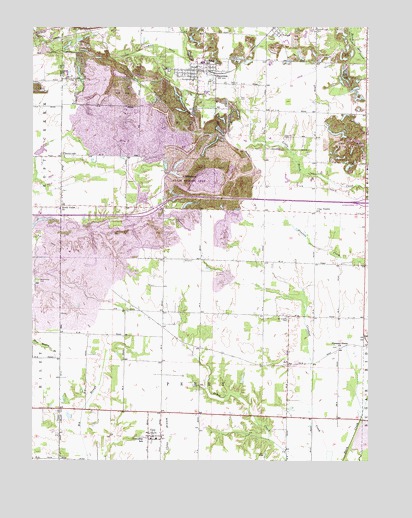
Staunton, IN USGS Topographic Map
Click on map above to begin viewing in our Map Viewer.

This topographic map contains these locations and features:
Feature Name Type Latitude Longitude GNIS ID View Map
ArtPopulated PlaceN39.4028°W87.1553°430282View Map
CherryvalePopulated PlaceN39.4634°W87.2395°432447View Map
Clay PrairieFlatN39.4025°W87.2045°447926View Map
Clay Prairie ChurchChurchN39.4470°W87.1445°432590View Map
CoryPopulated PlaceN39.3823°W87.2058°432999View Map
Cory Volunteer Fire DepartmentBuildingN39.3816°W87.2076°2626055View Map
German CemeteryCemeteryN39.4681°W87.1545°435040View Map
Mewhinney CemeteryCemeteryN39.4267°W87.2481°439057View Map
Mount Calvary CemeteryCemeteryN39.4159°W87.1553°439524View Map
North Union ChurchChurchN39.4484°W87.2389°440308View Map
Pleasant Grove ChurchChurchN39.4075°W87.1361°441259View Map
Posey Township Clay County Volunteer Fire DepartmentBuildingN39.4877°W87.1843°2626085View Map
Rhule CemeteryCemeteryN39.4442°W87.1972°441933View Map
StauntonPopulated PlaceN39.4875°W87.1889°449846View Map
Staunton Elementary SchoolSchoolN39.4903°W87.1875°446527View Map
Staunton High SchoolSchoolN39.4903°W87.1870°446526View Map
Summit Lawn CemeteryCemeteryN39.4997°W87.1455°444399View Map
Town of StauntonCivilN39.4864°W87.1890°2397680View Map
Township of PerryCivilN39.3766°W87.1903°453717View Map
Township of PoseyCivilN39.4756°W87.1833°453761View Map
TurnerPopulated PlaceN39.4984°W87.1603°444989View Map
Wheeler PrairieFlatN39.4309°W87.1328°447927View Map

Note: Coordinates in the location and feature list above are referenced to NAD83 datum.


Copyright (C) 2008-2024 Ryan Niemi / Sunset Dynamics ... All Rights Reserved