TopoQuest Logo
Do you find TopoQuest useful?
Help keep TopoQuest running and adding new maps/features by donating!
Bitcoin:  19c7KJd3qBynnjoSw5npx9KScwjBe4ifkT
Litecoin:  LXs6TkuXGGXo1vDsWCkWVdjQX94eUKd6ui
Home View Maps Find Maps Find Places Resources & Links


Bridgeport West, Texas Topographic Map

USGS Map Title: Bridgeport West, TX
USGS Map MRC: 33097B7
DRG (GeoTIFF) Download: o33097b7.tif


Neighboring USGS Topographic Map Quads:


  Crafton, TX  
33097C8
 

  Chico, TX  
33097C7
 

  Alvord, TX  
33097C6
 

  Wizard Wells, TX  
33097B8
 

  Bridgeport West, TX  
33097B7
 

  Bridgeport East, TX  
33097B6
 

  Gibtown, TX  
33097A8
 

  Boonsville, TX  
33097A7
 

  Cottondale, TX  
33097A6


Map MRC Location:

N34°
W98°
N34°
W97°
H8 H7 H6 H5 H4 H3 H2 H1
G8 G7 G6 G5 G4 G3 G2 G1
F8 F7 F6 F5 F4 F3 F2 F1
E8 E7 E6 E5 E4 E3 E2 E1
D8 D7 D6 D5 D4 D3 D2 D1
C8 C7 C6 C5 C4 C3 C2 C1
B8 B7 B6 B5 B4 B3 B2 B1
A8 A7 A6 A5 A4 A3 A2 A1
N33°
W98°
N33°
W97°

Bridgeport West, TX USGS 1:24K Topographic Map Preview:
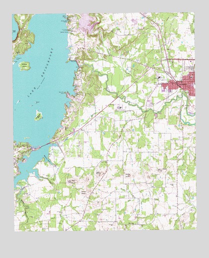
Bridgeport West, TX USGS Topographic Map
Click on map above to begin viewing in our Map Viewer.

This topographic map contains these locations and features:
Feature Name Type Latitude Longitude GNIS ID View Map
Bowlin MoundSummitN33.1579°W97.8148°1381190View Map
BridgeportPopulated PlaceN33.2101°W97.7548°1381191View Map
Bridgeport City HallBuildingN33.2132°W97.7586°2753495View Map
Bridgeport Correctional CenterBuildingN33.2361°W97.7580°2738637View Map
Bridgeport DamDamN33.2201°W97.8303°1857192View Map
Bridgeport DivisionCivilN33.2055°W97.8078°1938564View Map
Bridgeport Elementary SchoolSchoolN33.2093°W97.7514°2009279View Map
Bridgeport Municipal AirportAirportN33.1753°W97.8284°1386290View Map
Bridgeport Police DepartmentBuildingN33.2103°W97.7594°2738892View Map
Bridgeport Post OfficePost OfficeN33.2107°W97.7539°2731576View Map
Bridgeport Volunteer Fire DepartmentBuildingN33.2078°W97.7600°2551551View Map
Brushy MoundSummitN33.1565°W97.7959°1381193View Map
Bull Memorial StadiumParkN33.2034°W97.7523°2028007View Map
Calvary Apostolic ChurchChurchN33.2093°W97.7648°2024850View Map
Carlisle MoundSummitN33.1471°W97.8250°1381197View Map
Cates Street Baptist ChurchChurchN33.2093°W97.7703°2024852View Map
Church of ChristChurchN33.2093°W97.7534°2024865View Map
City of BridgeportCivilN33.2094°W97.7716°2409907View Map
City of Lake BridgeportCivilN33.2072°W97.8310°2411599View Map
City of Runaway BayCivilN33.1774°W97.8710°2411015View Map
Coal Bed BranchStreamN33.1601°W97.8636°1383065View Map
Crappie CoveBayN33.2259°W97.8720°1381201View Map
East MoundSummitN33.1590°W97.7753°1381208View Map
East Mound CemeteryCemeteryN33.1568°W97.7789°1381209View Map
First Baptist ChurchChurchN33.2093°W97.7556°2024857View Map
First Presbyterian ChurchChurchN33.2187°W97.7545°2024871View Map
Flying S Ranch AirportAirportN33.1318°W97.7686°1386288View Map
Hackberry SloughBayN33.1662°W97.8520°1381217View Map
Horse IslandIslandN33.1990°W97.8595°1381219View Map
Jim Sears AirportAirportN33.1395°W97.8044°1386289View Map
KWCS-FM (Bridgeport)TowerN33.2246°W97.7978°1385787View Map
Lake BridgeportPopulated PlaceN33.2071°W97.8286°1388612View Map
Lake Bridgeport City HallBuildingN33.2025°W97.8277°2753272View Map
Lake Bridgeport Volunteer Fire DepartmentBuildingN33.2027°W97.8276°2551824View Map
Lake Bridgeport Youth CampLocaleN33.2407°W97.8364°1381221View Map
Lone Star Industries DamDamN33.2401°W97.8220°1862881View Map
Lone Star Industries LakeReservoirN33.2404°W97.8216°1862882View Map
Marine Base SloughBayN33.2459°W97.8373°1381223View Map
Meacham SloughBayN33.2393°W97.8367°1381226View Map
Mexican CemeteryCemeteryN33.2204°W97.7842°1381227View Map
North Fork Rush CreekStreamN33.1385°W97.7514°1381234View Map
Oldtown CemeteryCemeteryN33.1973°W97.7809°1381236View Map
Pleasant Valley ChurchChurchN33.1651°W97.8117°1381244View Map
Ramsey CreekStreamN33.1932°W97.7845°1381246View Map
Rattlesnake IslandIslandN33.1921°W97.8581°1381247View Map
RickelsPopulated PlaceN33.1834°W97.8289°1381249View Map
Runaway Bay City HallBuildingN33.1731°W97.8664°2753914View Map
Runaway Bay Police DepartmentBuildingN33.1731°W97.8664°2739044View Map
Saddle GapGapN33.1840°W97.8400°1381252View Map
South Fork Rush CreekStreamN33.1385°W97.7514°1381261View Map
Spears SloughBayN33.2482°W97.8381°1381263View Map
Stripling IslandIslandN33.2207°W97.8670°1381264View Map
Trinity Lutheran ChurchChurchN33.2104°W97.7581°2024868View Map
Turkey CreekStreamN33.2023°W97.7573°1381267View Map
Twin Hills PointCapeN33.2051°W97.8398°1381268View Map
Twinhills Assembly of God ChurchChurchN33.2093°W97.7661°2024851View Map
United Pentecostal ChurchChurchN33.2062°W97.7684°2024870View Map
Village CreekStreamN33.1957°W97.7878°1383204View Map
West MoundSummitN33.1535°W97.8359°1349764View Map
Willow CreekStreamN33.1523°W97.8736°1381277View Map
Wilson Prairie ChurchChurchN33.1287°W97.7934°1381278View Map
Wise County Constable's Office Precinct 4BuildingN33.2080°W97.7550°2739121View Map

Note: Coordinates in the location and feature list above are referenced to NAD83 datum.


Copyright (C) 2008-2025 Ryan Niemi / Sunset Dynamics ... All Rights Reserved