TopoQuest Logo
Do you find TopoQuest useful?
Help keep TopoQuest running and adding new maps/features by donating!
Bitcoin:  19c7KJd3qBynnjoSw5npx9KScwjBe4ifkT
Litecoin:  LXs6TkuXGGXo1vDsWCkWVdjQX94eUKd6ui
Home View Maps Find Maps Find Places Resources & Links


Bright Angel Point, Arizona Topographic Map

USGS Map Title: Bright Angel Point, AZ
USGS Map MRC: 36112B1
DRG (GeoTIFF) Download: o36112b1.tif


Neighboring USGS Topographic Map Quads:


  Kanabownits Spring, AZ  
36112C2
 

  Little Park Lake, AZ  
36112C1
 

  Point Imperial, AZ  
36111C8
 

  Shiva Temple, AZ  
36112B2
 

  Bright Angel Point, AZ  
36112B1
 

  Walhalla Plateau, AZ  
36111B8
 

  Grand Canyon, AZ  
36112A2
 

  Phantom Ranch, AZ  
36112A1
 

  Cape Royal, AZ  
36111A8


Map MRC Location:

N37°
W113°
N37°
W112°
H8 H7 H6 H5 H4 H3 H2 H1
G8 G7 G6 G5 G4 G3 G2 G1
F8 F7 F6 F5 F4 F3 F2 F1
E8 E7 E6 E5 E4 E3 E2 E1
D8 D7 D6 D5 D4 D3 D2 D1
C8 C7 C6 C5 C4 C3 C2 C1
B8 B7 B6 B5 B4 B3 B2 B1
A8 A7 A6 A5 A4 A3 A2 A1
N36°
W113°
N36°
W112°

Bright Angel Point, AZ USGS 1:24K Topographic Map Preview:
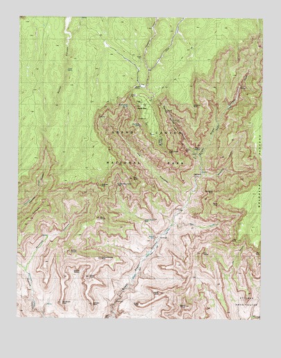
Bright Angel Point, AZ USGS Topographic Map
Click on map above to begin viewing in our Map Viewer.

This topographic map contains these locations and features:
Feature Name Type Latitude Longitude GNIS ID View Map
Ariel PointCliffN36.1536°W112.0010°763View Map
Brahma TempleSummitN36.1305°W112.0387°1939View Map
Bright Angel PointCliffN36.1930°W112.0488°1963View Map
Bright Angel SpringSpringN36.2203°W112.0679°1964View Map
Buddha CloisterSummitN36.1461°W112.0948°2120View Map
Buddha TempleSummitN36.1528°W112.0987°2121View Map
Clement Powell ButteSummitN36.1494°W112.0851°3008View Map
Cliff Dweller SpringSpringN36.2047°W112.0633°3012View Map
Cottonwood CampLocaleN36.1686°W112.0416°3305View Map
Deva TempleSummitN36.1521°W112.0318°3892View Map
Fuller CanyonValleyN36.2279°W112.0589°4879View Map
Grand Canyon LodgeBuildingN36.1972°W112.0532°5215View Map
Greenland SpringSpringN36.2439°W112.0010°5370View Map
Harvey MeadowFlatN36.2211°W112.0635°5592View Map
Hattan ButteSummitN36.1357°W112.0522°5610View Map
Haunted CanyonValleyN36.1450°W112.1211°5613View Map
Hillers ButteSummitN36.1424°W112.0887°5820View Map
Johnson PointCliffN36.1311°W112.0871°6477View Map
Jones PointCliffN36.1308°W112.0632°6496View Map
Komo PointCliffN36.1733°W112.0282°6769View Map
Lower Thompson SpringSpringN36.2416°W112.0599°7513View Map
Manu TempleSummitN36.1667°W112.0839°7653View Map
Manzanita CreekStreamN36.1850°W112.0321°7668View Map
Manzanita PointCliffN36.1789°W112.0257°7671View Map
Marble FlatsFlatN36.2325°W112.0721°7686View Map
North Kaibab TrailTrailN36.1694°W112.0402°43121View Map
North RimPopulated PlaceN36.2105°W112.0613°8757View Map
North Rim InnLocaleN36.2055°W112.0563°20928View Map
North Rim Post Office (historical)Post OfficeN36.2105°W112.0613°2026817View Map
Obi PointCliffN36.1578°W112.0127°8909View Map
Old Kaibab TrailTrailN36.2205°W112.0193°42961View Map
Outlet CanyonValleyN36.1987°W112.1122°9035View Map
Outlet SpringSpringN36.2281°W112.1009°9037View Map
Oza ButteSummitN36.1832°W112.0668°9072View Map
Ribbon FallsFallsN36.1595°W112.0556°10245View Map
Roaring SpringsSpringN36.1950°W112.0357°10352View Map
Roaring Springs CampgroundLocaleN36.1964°W112.0391°20989View Map
Roaring Springs CanyonValleyN36.1929°W112.0324°10353View Map
Schellbach ButteSummitN36.1483°W112.1112°21002View Map
Sturdevant PointCliffN36.1311°W112.1035°11906View Map
The ColonnadeSummitN36.1715°W112.1109°12303View Map
The TranseptValleyN36.1718°W112.0400°12382View Map
Thompson CanyonValleyN36.2214°W112.0607°12397View Map
Tiyo Point TrailTrailN36.2319°W112.1168°12514View Map
Transept TrailTrailN36.2008°W112.0577°12681View Map
Transept Trail CampgroundsParkN36.2139°W112.0613°21071View Map
Uncle Jim PointCliffN36.2133°W112.0366°42844View Map
Wall CreekStreamN36.1644°W112.0449°13298View Map
Widforss PointCliffN36.1794°W112.0835°13741View Map

Note: Coordinates in the location and feature list above are referenced to NAD83 datum.


Copyright (C) 2008-2025 Ryan Niemi / Sunset Dynamics ... All Rights Reserved