TopoQuest Logo
Do you find TopoQuest useful?
Help keep TopoQuest running and adding new maps/features by donating!
Bitcoin:  19c7KJd3qBynnjoSw5npx9KScwjBe4ifkT
Litecoin:  LXs6TkuXGGXo1vDsWCkWVdjQX94eUKd6ui
Home View Maps Find Maps Find Places Resources & Links


Aliceville South, Alabama Topographic Map

USGS Map Title: Aliceville South, AL
USGS Map MRC: 33088A2
DRG (GeoTIFF) Download: o33088a2.tif


Neighboring USGS Topographic Map Quads:


  Pickensville, AL  
33088B3
 

  Aliceville North, AL  
33088B2
 

  Cunningham, AL  
33088B1
 

  Dancy, AL  
33088A3
 

  Aliceville South, AL  
33088A2
 

  Pleasant Ridge, AL  
33088A1
 

  Panola, AL  
32088H3
 

  Warsaw, AL  
32088H2
 

  West Greene, AL  
32088H1


Map MRC Location:

N34°
W89°
N34°
W88°
H8 H7 H6 H5 H4 H3 H2 H1
G8 G7 G6 G5 G4 G3 G2 G1
F8 F7 F6 F5 F4 F3 F2 F1
E8 E7 E6 E5 E4 E3 E2 E1
D8 D7 D6 D5 D4 D3 D2 D1
C8 C7 C6 C5 C4 C3 C2 C1
B8 B7 B6 B5 B4 B3 B2 B1
A8 A7 A6 A5 A4 A3 A2 A1
N33°
W89°
N33°
W88°

Aliceville South, AL USGS 1:24K Topographic Map Preview:
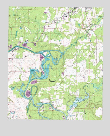
Aliceville South, AL USGS Topographic Map
Click on map above to begin viewing in our Map Viewer.

This topographic map contains these locations and features:
Feature Name Type Latitude Longitude GNIS ID View Map
Aliceville Division (historical)CensusN33.1154°W88.1778°165922View Map
Aliceville High SchoolSchoolN33.1233°W88.1483°135453View Map
Antioch CemeteryCemeteryN33.0015°W88.2467°163324View Map
Antioch CemeteryCemeteryN33.0015°W88.2470°158598View Map
Antioch ChurchChurchN33.0015°W88.2467°113153View Map
Bethany ChurchChurchN33.0487°W88.1261°113994View Map
Blubber CreekStreamN33.0743°W88.1803°114526View Map
BridgevillePopulated PlaceN33.1048°W88.1420°156112View Map
Camp Aliceville (historical)MilitaryN33.1139°W88.1739°2118335View Map
Catfish BarBarN33.0510°W88.2020°135483View Map
Catfish BendBendN33.0504°W88.2192°135484View Map
Catfish ShoalsBarN33.0468°W88.2067°135485View Map
Cedar Creek ShoalsBarN33.0779°W88.2448°135487View Map
City of AlicevilleCivilN33.1237°W88.1594°2403080View Map
Cochrane Ferry (historical)CrossingN33.0796°W88.2375°135498View Map
Cow Creek RanchLocaleN33.0686°W88.2261°2674742View Map
Crim LakeLakeN33.1150°W88.2431°116869View Map
Cuba LandingLocaleN33.0137°W88.2128°135507View Map
Cuba ShoalsBarN33.0143°W88.2103°135508View Map
Dead RiverSwampN33.0455°W88.1848°117162View Map
Fowler CemeteryCemeteryN33.1118°W88.1409°158605View Map
Gardner CemeteryCemeteryN33.1010°W88.1445°135526View Map
George Downer AirportAirportN33.1090°W88.1903°129453View Map
Goose PondLakeN33.0987°W88.2195°135529View Map
Hancock ShoalsBarN33.0426°W88.2220°135535View Map
Huyck BridgeBridgeN33.0807°W88.2375°135545View Map
J S Sommerville DamDamN33.1035°W88.1567°131217View Map
J S Sommerville LakeReservoirN33.1056°W88.1569°131216View Map
Jones CemeteryCemeteryN33.0146°W88.1342°120990View Map
Kearnens BendBendN33.0660°W88.1820°135552View Map
Lubbub BarBarN33.0718°W88.1800°135565View Map
Lubbub CreekStreamN33.0726°W88.1939°154473View Map
McCaa CemeteryCemeteryN33.0843°W88.1820°122452View Map
Moon LakeLakeN33.0157°W88.1600°122983View Map
Mouth of Sipsey Landing (historical)LocaleN33.0029°W88.1717°132656View Map
New Canaan ChurchChurchN33.1137°W88.1950°123730View Map
Newport (historical)LocaleN33.0773°W88.2214°135588View Map
Newport ShoalsBarN33.0768°W88.2220°135589View Map
Old Bethany CemeteryCemeteryN33.0493°W88.1259°138754View Map
Providence ChurchChurchN33.0710°W88.1411°125329View Map
RidgePopulated PlaceN33.0082°W88.1486°156966View Map
Sipsey BarBarN33.0023°W88.1717°132703View Map
Sipsey Island (historical)IslandN33.0043°W88.1742°135624View Map
Sipsey RiverStreamN33.0040°W88.1720°158924View Map
Stones Ferry (historical)CrossingN33.0798°W88.2389°135630View Map
Streets IslandIslandN33.0754°W88.2064°135631View Map
Summerville BarBarN33.0751°W88.1973°135632View Map
Summerville Cutoff BarBarN33.0704°W88.1967°135633View Map
Thomas Landing (historical)LocaleN33.0710°W88.1789°135634View Map
Trantham CemeteryCemeteryN33.0712°W88.1428°158940View Map
ViennaPopulated PlaceN33.0187°W88.1920°157201View Map
Vienna Access AreaParkN33.0176°W88.1923°135639View Map
Vienna BarBarN33.0168°W88.1953°135640View Map
Vienna Island (historical)IslandN33.0132°W88.1903°135642View Map
William CemeteryCemeteryN33.0412°W88.1778°158958View Map
Windhams BarBarN33.0290°W88.2306°135647View Map
Windhams LandingLocaleN33.0290°W88.2339°135648View Map

Note: Coordinates in the location and feature list above are referenced to NAD83 datum.


Copyright (C) 2008-2025 Ryan Niemi / Sunset Dynamics ... All Rights Reserved