TopoQuest Logo
Do you find TopoQuest useful?
Help keep TopoQuest running and adding new maps/features by donating!
Bitcoin:  19c7KJd3qBynnjoSw5npx9KScwjBe4ifkT
Litecoin:  LXs6TkuXGGXo1vDsWCkWVdjQX94eUKd6ui
Home View Maps Find Maps Find Places Resources & Links


Brighton, Iowa Topographic Map

USGS Map Title: Brighton, IA
USGS Map MRC: 41091B7
DRG (GeoTIFF) Download: o41091b7.tif


Neighboring USGS Topographic Map Quads:


  Keota, IA  
41091C8
 

  West Chester, IA  
41091C7
 

  Washington, IA  
41091C6
 

  Richland, IA  
41091B8
 

  Brighton, IA  
41091B7
 

  Wayland, IA  
41091B6
 

  Fairfield North, IA  
41091A8
 

  Salina, IA  
41091A7
 

  Trenton, IA  
41091A6


Map MRC Location:

N42°
W92°
N42°
W91°
H8 H7 H6 H5 H4 H3 H2 H1
G8 G7 G6 G5 G4 G3 G2 G1
F8 F7 F6 F5 F4 F3 F2 F1
E8 E7 E6 E5 E4 E3 E2 E1
D8 D7 D6 D5 D4 D3 D2 D1
C8 C7 C6 C5 C4 C3 C2 C1
B8 B7 B6 B5 B4 B3 B2 B1
A8 A7 A6 A5 A4 A3 A2 A1
N41°
W92°
N41°
W91°

Brighton, IA USGS 1:24K Topographic Map Preview:
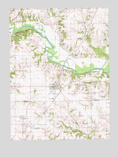
Brighton, IA USGS Topographic Map
Click on map above to begin viewing in our Map Viewer.

This topographic map contains these locations and features:
Feature Name Type Latitude Longitude GNIS ID View Map
Benton Timbers ParkParkN41.2250°W91.8613°1825048View Map
BrightonPopulated PlaceN41.1747°W91.8196°454825View Map
Brighton (historical)LocaleN41.1722°W91.8224°1981764View Map
Brighton Boat AccessLocaleN41.1945°W91.8071°1981607View Map
Brighton City HallBuildingN41.1750°W91.8216°1981765View Map
Brighton Police DepartmentBuildingN41.1750°W91.8216°1981766View Map
Brighton Post OfficePost OfficeN41.1745°W91.8202°1981767View Map
Brighton United ChurchChurchN41.1736°W91.8229°1981759View Map
Brighton Volunteer Fire and RescueBuildingN41.1752°W91.8210°2577455View Map
Brinton Timbers ParkParkN41.2278°W91.8599°1981817View Map
City of BrightonCivilN41.1747°W91.8212°2393419View Map
City of Pleasant PlainCivilN41.1472°W91.8596°2396233View Map
East Pleasant PlainPopulated PlaceN41.1367°W91.8502°456190View Map
East Pleasant Plain (historical)LocaleN41.1361°W91.8502°1976333View Map
East Pleasant Plain Post Office (historical)Post OfficeN41.1361°W91.8502°1976334View Map
First Church of GodChurchN41.1709°W91.8229°1981760View Map
Friends CemeteryCemeteryN41.1478°W91.8638°456781View Map
Gatlin CemeteryCemeteryN41.2417°W91.8252°1981816View Map
Hillcrest CemeteryCemeteryN41.1797°W91.8177°457492View Map
Hope Lutheran ChurchChurchN41.1747°W91.8196°1981763View Map
Horseshoe LakeLakeN41.2342°W91.8335°1825049View Map
Indian CreekStreamN41.2136°W91.8210°457789View Map
Miller CemeteryCemeteryN41.2400°W91.7729°459099View Map
Pleasant PlainPopulated PlaceN41.1472°W91.8591°460275View Map
Pleasant Plain Friends ChurchChurchN41.1478°W91.8627°1981387View Map
Pleasant Plain Post Office (historical)Post OfficeN41.1472°W91.8591°1976350View Map
Saint Josephs CemeteryCemeteryN41.1359°W91.8466°461109View Map
Saint Josephs ChurchChurchN41.1747°W91.8196°1981761View Map
Samuel Lewis Historical MarkerParkN41.1797°W91.8174°1981782View Map
Sandy Hook CemeteryCemeteryN41.2050°W91.7960°461418View Map
Shuppy CemeteryCemeteryN41.1452°W91.7585°461594View Map
Township of BrightonCivilN41.2055°W91.7875°467486View Map
Verdi (historical)LocaleN41.2361°W91.7793°1981637View Map
Verdi Post Office (historical)Post OfficeN41.2361°W91.7793°1981636View Map
Victory Fellowship ChurchChurchN41.1739°W91.8127°1981758View Map
Wallrich LakeLakeN41.2366°W91.8424°462625View Map
Walnut SchoolSchoolN41.2345°W91.7702°462652View Map
Washington Church of GodChurchN41.1747°W91.8196°1981762View Map
West Walnut CreekStreamN41.2172°W91.7727°462927View Map

Note: Coordinates in the location and feature list above are referenced to NAD83 datum.


Copyright (C) 2008-2024 Ryan Niemi / Sunset Dynamics ... All Rights Reserved