TopoQuest Logo
Do you find TopoQuest useful?
Help keep TopoQuest running and adding new maps/features by donating!
Bitcoin:  19c7KJd3qBynnjoSw5npx9KScwjBe4ifkT
Litecoin:  LXs6TkuXGGXo1vDsWCkWVdjQX94eUKd6ui
Home View Maps Find Maps Find Places Resources & Links


Brooks, Iowa Topographic Map

USGS Map Title: Brooks, IA
USGS Map MRC: 40094H7
DRG (GeoTIFF) Download: o40094h7.tif


Neighboring USGS Topographic Map Quads:


  Morton Mills, IA  
41094A8
 

  Carbon, IA  
41094A7
 

  Corning North, IA  
41094A6
 

  Villisca, IA  
40094H8
 

  Brooks, IA  
40094H7
 

  Corning South, IA  
40094H6
 

  Hawleyville, IA  
40094G8
 

  Guss, IA  
40094G7
 

  Gravity, IA  
40094G6


Map MRC Location:

N41°
W95°
N41°
W94°
H8 H7 H6 H5 H4 H3 H2 H1
G8 G7 G6 G5 G4 G3 G2 G1
F8 F7 F6 F5 F4 F3 F2 F1
E8 E7 E6 E5 E4 E3 E2 E1
D8 D7 D6 D5 D4 D3 D2 D1
C8 C7 C6 C5 C4 C3 C2 C1
B8 B7 B6 B5 B4 B3 B2 B1
A8 A7 A6 A5 A4 A3 A2 A1
N40°
W95°
N40°
W94°

Brooks, IA USGS 1:24K Topographic Map Preview:
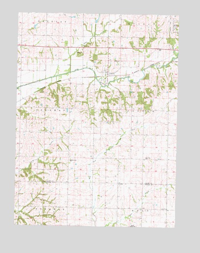
Brooks, IA USGS Topographic Map
Click on map above to begin viewing in our Map Viewer.

This topographic map contains these locations and features:
Feature Name Type Latitude Longitude GNIS ID View Map
Baldwin CemeteryCemeteryN40.9769°W94.8247°454331View Map
BrooksLocaleN40.9633°W94.8053°1968907View Map
BrooksPopulated PlaceN40.9653°W94.8050°454843View Map
Brooks CemeteryCemeteryN40.9724°W94.7957°454844View Map
Brooks Methodist ChurchChurchN40.9655°W94.8058°1968944View Map
Brooks Post Office (historical)Post OfficeN40.9653°W94.8050°1968908View Map
Brown Truck Sales Airport (historical)AirportN40.8972°W94.7911°466751View Map
Corning Municipal AirportAirportN40.9973°W94.7557°466750View Map
Corning QuarryMineN40.9725°W94.7517°2628371View Map
Fairview ChurchChurchN40.8855°W94.7575°456505View Map
IveyvillePopulated PlaceN40.9008°W94.7958°457878View Map
Iveyville Post Office (historical)Post OfficeN40.9008°W94.7958°1968896View Map
Kemp CreekStreamN40.9653°W94.8339°458036View Map
Methodist Grove CemeteryCemeteryN40.9136°W94.8336°459013View Map
Old Brooks CemeteryCemeteryN40.9833°W94.7669°1968963View Map
Prairie Rose CemeteryCemeteryN40.9155°W94.7755°460420View Map
Snider BridgeBridgeN40.9867°W94.8297°1968966View Map
Township of JasperCivilN40.9434°W94.7575°468125View Map
Township of NodawayCivilN40.9435°W94.8716°468445View Map

Note: Coordinates in the location and feature list above are referenced to NAD83 datum.


Copyright (C) 2008-2025 Ryan Niemi / Sunset Dynamics ... All Rights Reserved