TopoQuest Logo
Do you find TopoQuest useful?
Help keep TopoQuest running and adding new maps/features by donating!
Bitcoin:  19c7KJd3qBynnjoSw5npx9KScwjBe4ifkT
Litecoin:  LXs6TkuXGGXo1vDsWCkWVdjQX94eUKd6ui
Home View Maps Find Maps Find Places Resources & Links


Brownsville, Indiana Topographic Map

USGS Map Title: Brownsville, IN
USGS Map MRC: 39085F1
DRG (GeoTIFF) Download: o39085f1.tif


Neighboring USGS Topographic Map Quads:


  Cambridge City, IN  
39085G2
 

  Jacksonburg, IN  
39085G1
 

  Richmond, IN  
39084G8
 

  Connersville, IN  
39085F2
 

  Brownsville, IN  
39085F1
 

  Liberty, IN  
39084F8
 

  Alpine, IN  
39085E2
 

  Everton, IN  
39085E1
 

  New Fairfield, IN  
39084E8


Map MRC Location:

N40°
W86°
N40°
W85°
H8 H7 H6 H5 H4 H3 H2 H1
G8 G7 G6 G5 G4 G3 G2 G1
F8 F7 F6 F5 F4 F3 F2 F1
E8 E7 E6 E5 E4 E3 E2 E1
D8 D7 D6 D5 D4 D3 D2 D1
C8 C7 C6 C5 C4 C3 C2 C1
B8 B7 B6 B5 B4 B3 B2 B1
A8 A7 A6 A5 A4 A3 A2 A1
N39°
W86°
N39°
W85°

Brownsville, IN USGS 1:24K Topographic Map Preview:
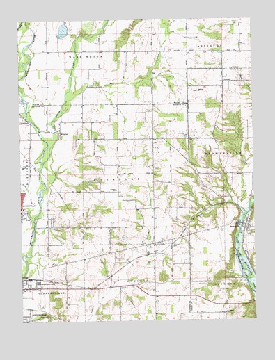
Brownsville, IN USGS Topographic Map
Click on map above to begin viewing in our Map Viewer.

This topographic map contains these locations and features:
Feature Name Type Latitude Longitude GNIS ID View Map
BrownsvillePopulated PlaceN39.6645°W85.0047°431648View Map
Butlers CreekStreamN39.7164°W85.0991°431905View Map
Clark's GreenhousesBuildingN39.6383°W85.1156°2649886View Map
Connersville Fire Department Station 4BuildingN39.6378°W85.1245°2626257View Map
Green CemeteryCemeteryN39.7062°W85.1055°2710836View Map
Lick CreekStreamN39.6670°W85.1186°437866View Map
LyonsvillePopulated PlaceN39.6525°W85.0539°438443View Map
Mount Pleasant ChurchChurchN39.6281°W85.0161°439682View Map
Mud RunStreamN39.6873°W85.1147°439847View Map
Nolands ForkStreamN39.6906°W85.1127°440196View Map
PhilomathPopulated PlaceN39.7239°W85.0158°441093View Map
Philomath ChurchChurchN39.7203°W85.0291°441094View Map
Robinson Chapel CemeteryCemeteryN39.6988°W85.0532°2710837View Map
Shrine of Memories MausoleumCemeteryN39.6397°W85.1145°2710169View Map
Simpson CemeteryCemeteryN39.6562°W85.0438°443531View Map
Simpson CreekStreamN39.6684°W85.0047°443536View Map
SpringersvillePopulated PlaceN39.6573°W85.0539°444008View Map
Springersville CemeteryCemeteryN39.6582°W85.0542°2708279View Map
Squires AirportAirportN39.7150°W85.0478°449130View Map
Township of WaterlooCivilN39.6860°W85.0751°454026View Map
Turkey CreekStreamN39.6431°W85.0055°449070View Map
Union CemeteryCemeteryN39.6493°W85.0550°445058View Map
Village Creek ChurchChurchN39.6269°W85.1109°445296View Map
Village Creek Church CemeteryCemeteryN39.6265°W85.1107°2709316View Map
WaterlooPopulated PlaceN39.7037°W85.1030°445541View Map
Whitewater CanalCanalN39.7487°W85.1230°445981View Map

Note: Coordinates in the location and feature list above are referenced to NAD83 datum.


Copyright (C) 2008-2025 Ryan Niemi / Sunset Dynamics ... All Rights Reserved