TopoQuest Logo
Do you find TopoQuest useful?
Help keep TopoQuest running and adding new maps/features by donating!
Bitcoin:  19c7KJd3qBynnjoSw5npx9KScwjBe4ifkT
Litecoin:  LXs6TkuXGGXo1vDsWCkWVdjQX94eUKd6ui
Home View Maps Find Maps Find Places Resources & Links


Everton, Indiana Topographic Map

USGS Map Title: Everton, IN
USGS Map MRC: 39085E1
DRG (GeoTIFF) Download: o39085e1.tif


Neighboring USGS Topographic Map Quads:


  Connersville, IN  
39085F2
 

  Brownsville, IN  
39085F1
 

  Liberty, IN  
39084F8
 

  Alpine, IN  
39085E2
 

  Everton, IN  
39085E1
 

  New Fairfield, IN  
39084E8
 

  Metamora, IN  
39085D2
 

  Brookville, IN  
39085D1
 

  Whitcomb, IN  
39084D8


Map MRC Location:

N40°
W86°
N40°
W85°
H8 H7 H6 H5 H4 H3 H2 H1
G8 G7 G6 G5 G4 G3 G2 G1
F8 F7 F6 F5 F4 F3 F2 F1
E8 E7 E6 E5 E4 E3 E2 E1
D8 D7 D6 D5 D4 D3 D2 D1
C8 C7 C6 C5 C4 C3 C2 C1
B8 B7 B6 B5 B4 B3 B2 B1
A8 A7 A6 A5 A4 A3 A2 A1
N39°
W86°
N39°
W85°

Everton, IN USGS 1:24K Topographic Map Preview:
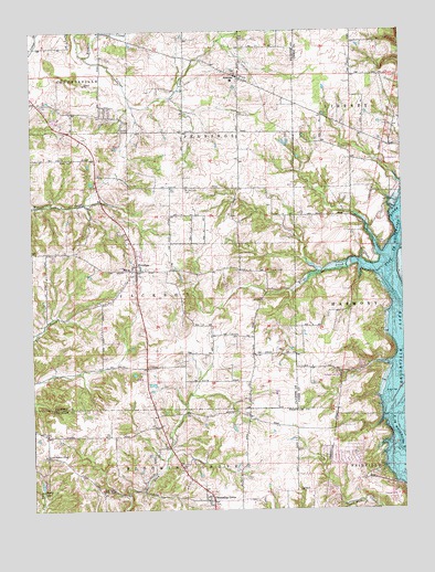
Everton, IN USGS Topographic Map
Click on map above to begin viewing in our Map Viewer.

This topographic map contains these locations and features:
Feature Name Type Latitude Longitude GNIS ID View Map
AlquinaPopulated PlaceN39.6128°W85.0547°430116View Map
Alquina Elementary SchoolSchoolN39.6125°W85.0555°446585View Map
Blooming GrovePopulated PlaceN39.5023°W85.0647°431201View Map
Blooming Grove Volunteer Fire DepartmentBuildingN39.5025°W85.0665°2626452View Map
Burke CemeteryCemeteryN39.6206°W85.0646°2710165View Map
Duck Creek Stone ChapelChurchN39.5045°W85.1014°449788View Map
Ellys CreekStreamN39.5628°W85.0186°434115View Map
EvertonPopulated PlaceN39.5628°W85.0897°434271View Map
Everton CemeteryCemeteryN39.5598°W85.0902°2710163View Map
Everton Volunteer Fire DepartmentBuildingN39.5629°W85.0901°2625930View Map
Fishers CreekStreamN39.6187°W85.1072°434527View Map
Hanna CreekStreamN39.5528°W85.0014°435688View Map
Hanson-Crandel CemeteryCemeteryN39.5984°W85.0501°2710399View Map
Little Children Home ChurchChurchN39.5134°W85.1202°438011View Map
Mount Garrison CemeteryCemeteryN39.5842°W85.0730°439563View Map
O Waters CemeteryCemeteryN39.5274°W85.0679°2710164View Map
Old Parrot CemeteryCemeteryN39.5276°W85.0868°2710398View Map
PinhookPopulated PlaceN39.5114°W85.0744°449036View Map
Poplar Ridge CemeteryCemeteryN39.5620°W85.0447°441397View Map
QuakertownPopulated PlaceN39.5800°W85.0016°452138View Map
Shady LakeLakeN39.5064°W85.1222°443249View Map
Township of JacksonCivilN39.5568°W85.1067°453443View Map
Township of JenningsCivilN39.6134°W85.0637°453507View Map

Note: Coordinates in the location and feature list above are referenced to NAD83 datum.


Copyright (C) 2008-2024 Ryan Niemi / Sunset Dynamics ... All Rights Reserved