TopoQuest Logo
Do you find TopoQuest useful?
Help keep TopoQuest running and adding new maps/features by donating!
Bitcoin:  19c7KJd3qBynnjoSw5npx9KScwjBe4ifkT
Litecoin:  LXs6TkuXGGXo1vDsWCkWVdjQX94eUKd6ui
Home View Maps Find Maps Find Places Resources & Links


Bruce, Mississippi Topographic Map

USGS Map Title: Bruce, MS
USGS Map MRC: 33089H3
DRG (GeoTIFF) Download: o33089h3.tif


Neighboring USGS Topographic Map Quads:


  Banner, MS  
34089A4
 

  Sarepta, MS  
34089A3
 

  Robbs, MS  
34089A2
 

  Skuna, MS  
33089H4
 

  Bruce, MS  
33089H3
 

  Vardaman, MS  
33089H2
 

  Big Creek, MS  
33089G4
 

  Calhoun City, MS  
33089G3
 

  Atlanta, MS  
33089G2


Map MRC Location:

N34°
W90°
N34°
W89°
H8 H7 H6 H5 H4 H3 H2 H1
G8 G7 G6 G5 G4 G3 G2 G1
F8 F7 F6 F5 F4 F3 F2 F1
E8 E7 E6 E5 E4 E3 E2 E1
D8 D7 D6 D5 D4 D3 D2 D1
C8 C7 C6 C5 C4 C3 C2 C1
B8 B7 B6 B5 B4 B3 B2 B1
A8 A7 A6 A5 A4 A3 A2 A1
N33°
W90°
N33°
W89°

Bruce, MS USGS 1:24K Topographic Map Preview:
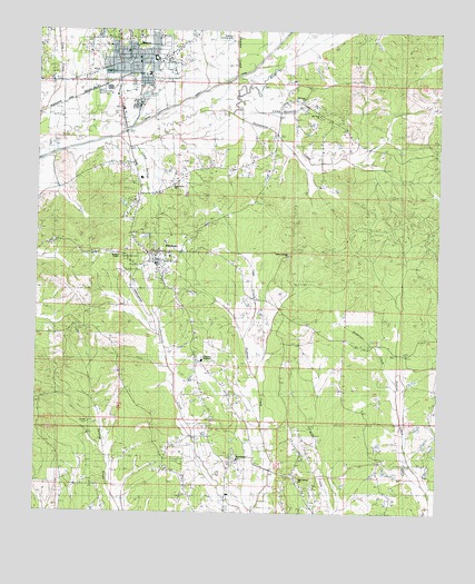
Bruce, MS USGS Topographic Map
Click on map above to begin viewing in our Map Viewer.

This topographic map contains these locations and features:
Feature Name Type Latitude Longitude GNIS ID View Map
Alexander Lake DamDamN33.8868°W89.2517°682386View Map
Anderson CreekStreamN33.9093°W89.2631°666259View Map
Believers Fellowship ChurchChurchN33.9918°W89.3476°683360View Map
Bridges ChapelChurchN33.9418°W89.3492°667569View Map
BrucePopulated PlaceN33.9921°W89.3490°667656View Map
Bruce Church of ChristChurchN33.9946°W89.3476°683363View Map
Bruce Elementary SchoolSchoolN33.9934°W89.3395°705956View Map
Bruce Fire DepartmentBuildingN33.9911°W89.3446°2665920View Map
Bruce High SchoolSchoolN33.9890°W89.3409°705957View Map
Bruce Middle SchoolSchoolN33.9926°W89.3395°705958View Map
Bruce Police DepartmentBuildingN33.9910°W89.3446°2754138View Map
Bruce Post OfficePost OfficeN33.9943°W89.3476°2768646View Map
Bruce United Methodist ChurchChurchN33.9918°W89.3440°683364View Map
Calhoun AcademySchoolN33.9146°W89.3234°683365View Map
Calhoun CountyCivilN33.9365°W89.3364°695731View Map
Calhoun County AirportAirportN33.9339°W89.3448°680415View Map
Calhoun County CourthouseBuildingN33.9393°W89.3379°683366View Map
Calhoun County Sheriff's OfficeBuildingN33.9346°W89.3361°2754262View Map
Camp Ground BranchStreamN33.9834°W89.3048°667973View Map
Camp Springs CreekStreamN33.9687°W89.3434°667989View Map
Centerville CemeteryCemeteryN33.9418°W89.3478°668266View Map
Centerville ChurchChurchN33.9418°W89.3479°668271View Map
Cowpen CreekStreamN33.9890°W89.3134°668910View Map
Duncan Hill CemeteryCemeteryN33.8751°W89.2606°669507View Map
Duncan Hill ChurchChurchN33.8751°W89.2606°669508View Map
First Baptist ChurchChurchN33.9926°W89.3440°683374View Map
Gaston Springs CemeteryCemeteryN33.9415°W89.2976°670329View Map
Gaston Springs ChurchChurchN33.9429°W89.2973°670330View Map
Gauley CemeteryCemeteryN33.8984°W89.3578°670340View Map
Hartford (historical)LocaleN33.9904°W89.3126°683376View Map
Jess Yancey Lake DamDamN33.9968°W89.3634°682433View Map
Jesse Yancy Memorial LibraryBuildingN33.9946°W89.3470°683379View Map
Macedonia CemeteryCemeteryN33.8893°W89.3120°672992View Map
Macedonia Missionary Baptist ChurchChurchN33.8893°W89.3120°673020View Map
Oak Grove (historical)LocaleN33.9807°W89.2801°683386View Map
Oak Grove Baptist ChurchChurchN33.9596°W89.3326°675054View Map
Oak Springs CemeteryCemeteryN33.8834°W89.2931°675102View Map
Oak Springs ChurchChurchN33.8834°W89.2931°675103View Map
Old Town CemeteryCemeteryN33.9837°W89.2920°675264View Map
Old Town ChurchChurchN33.9784°W89.2879°675265View Map
Old Town ChurchChurchN33.9837°W89.2920°675266View Map
PittsboroPopulated PlaceN33.9404°W89.3376°690930View Map
Pittsboro Baptist ChurchChurchN33.9404°W89.3390°683388View Map
Pittsboro CemeteryCemeteryN33.9346°W89.3348°705976View Map
Pittsboro Fire DepartmentBuildingN33.9405°W89.3360°2665893View Map
Pittsboro Post OfficePost OfficeN33.9400°W89.3374°2768652View Map
Pittsboro United Methodist ChurchChurchN33.9387°W89.3379°683389View Map
Stewart Lake DamDamN33.9284°W89.2584°682404View Map
Thompsons CreekStreamN33.9787°W89.3142°678718View Map
Town of BruceCivilN33.9909°W89.3455°2405334View Map
Twin CreekStreamN33.9201°W89.3104°679000View Map
Village of PittsboroCivilN33.9400°W89.3373°2407525View Map

Note: Coordinates in the location and feature list above are referenced to NAD83 datum.


Copyright (C) 2008-2024 Ryan Niemi / Sunset Dynamics ... All Rights Reserved