TopoQuest Logo
Do you find TopoQuest useful?
Help keep TopoQuest running and adding new maps/features by donating!
Bitcoin:  19c7KJd3qBynnjoSw5npx9KScwjBe4ifkT
Litecoin:  LXs6TkuXGGXo1vDsWCkWVdjQX94eUKd6ui
Home View Maps Find Maps Find Places Resources & Links


Alleghany, California Topographic Map

USGS Map Title: Alleghany, CA
USGS Map MRC: 39120D7
DRG (GeoTIFF) Download: o39120d7.tif


Neighboring USGS Topographic Map Quads:


  Goodyears Bar, CA  
39120E8
 

  Downieville, CA  
39120E7
 

  Sierra City, CA  
39120E6
 

  Pike, CA  
39120D8
 

  Alleghany, CA  
39120D7
 

  Graniteville, CA  
39120D6
 

  North Bloomfield, CA  
39120C8
 

  Washington, CA  
39120C7
 

  Blue Canyon, CA  
39120C6


Map MRC Location:

N40°
W121°
N40°
W120°
H8 H7 H6 H5 H4 H3 H2 H1
G8 G7 G6 G5 G4 G3 G2 G1
F8 F7 F6 F5 F4 F3 F2 F1
E8 E7 E6 E5 E4 E3 E2 E1
D8 D7 D6 D5 D4 D3 D2 D1
C8 C7 C6 C5 C4 C3 C2 C1
B8 B7 B6 B5 B4 B3 B2 B1
A8 A7 A6 A5 A4 A3 A2 A1
N39°
W121°
N39°
W120°

Alleghany, CA USGS 1:24K Topographic Map Preview:
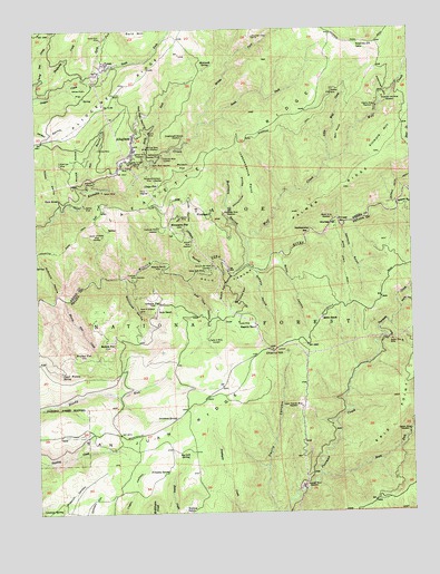
Alleghany, CA USGS Topographic Map
Click on map above to begin viewing in our Map Viewer.

This topographic map contains these locations and features:
Feature Name Type Latitude Longitude GNIS ID View Map
Alaskan MineMineN39.4841°W120.7761°256149View Map
AlleghanyPopulated PlaceN39.4696°W120.8433°256186View Map
Alleghany Census Designated PlaceCensusN39.4667°W120.8411°2582931View Map
Alleghany Post OfficePost OfficeN39.4726°W120.8432°2769317View Map
Alleghany Volunteer Fire DepartmentBuildingN39.4717°W120.8431°2622025View Map
American FlatFlatN39.4841°W120.8608°256218View Map
American HillSummitN39.4857°W120.7602°1657925View Map
American Hill (historical)Populated PlaceN39.4838°W120.7594°1701204View Map
American Hill CabinLocaleN39.4955°W120.7680°256220View Map
American Hill MineMineN39.4821°W120.7597°256222View Map
Ancho Erie MineMineN39.4182°W120.7544°256234View Map
Arcade MineMineN39.4516°W120.8277°256306View Map
Balsam FlatFlatN39.4646°W120.8263°256489View Map
Bathhouse RavineValleyN39.4355°W120.8463°256589View Map
Bayes Cabin RoadTrailN39.4382°W120.7733°256605View Map
Bayes MineMineN39.4507°W120.7769°256606View Map
Bedbug Smith TrailTrailN39.4602°W120.7549°256777View Map
Bell PointCapeN39.4721°W120.7747°256806View Map
Big Lick SpringSpringN39.3896°W120.8263°256955View Map
Black Cut RavineValleyN39.4360°W120.8108°257113View Map
Buck RanchLocaleN39.4277°W120.8349°257584View Map
Buckeye RavineValleyN39.4392°W120.8057°257607View Map
Cape HornRidgeN39.4735°W120.8641°264854View Map
Centennial RavineValleyN39.4536°W120.8117°258169View Map
Centerville (historical)Populated PlaceN39.4546°W120.8344°1733150View Map
Cherry HillSummitN39.4168°W120.7977°258248View Map
Chinese BarBarN39.4493°W120.7741°258320View Map
Chips FlatLocaleN39.4599°W120.8344°258339View Map
Cold Springs Ranch (historical)LocaleN39.4718°W120.8677°1733151View Map
Coleman SpringSpringN39.3758°W120.8686°258587View Map
Dempsey SpringSpringN39.3853°W120.8343°259274View Map
Dillon (historical)Populated PlaceN39.3849°W120.7819°1682875View Map
Dreadnaught MineMineN39.4727°W120.8263°259527View Map
Eldorado MineMineN39.4668°W120.8333°259823View Map
Erie PointCapeN39.3988°W120.7572°259953View Map
Fellows Mill (historical)LocaleN39.4380°W120.8183°1733193View Map
Fillmore HillSummitN39.4721°W120.7588°1658536View Map
ForestPopulated PlaceN39.4913°W120.8530°1658559View Map
Freds Ranch (historical)LocaleN39.4857°W120.8558°1733194View Map
French RavineValleyN39.4580°W120.8594°260402View Map
Fruitvale MineMineN39.4355°W120.8436°260435View Map
Gaston MineMineN39.3960°W120.7524°260504View Map
German Bar MineMineN39.4388°W120.8166°260537View Map
Golconda RavineValleyN39.4360°W120.8099°260638View Map
Gold CanyonValleyN39.4346°W120.8252°260642View Map
Gold Crown MineMineN39.4649°W120.8469°260645View Map
Gold Star MineMineN39.4660°W120.8677°260666View Map
Hagerty RanchLocaleN39.4232°W120.8022°261008View Map
Hells Half AcreAreaN39.4805°W120.8452°1733195View Map
Hope RavineValleyN39.4482°W120.8236°261454View Map
Howie MineMineN39.4241°W120.8086°261582View Map
Hub MineMineN39.4688°W120.8547°261584View Map
Independence PointCliffN39.4643°W120.8055°261704View Map
Ireland MineMineN39.4452°W120.8244°261802View Map
Jackass RavineValleyN39.4380°W120.8177°261864View Map
Jackass SpringSpringN39.4545°W120.8291°1662436View Map
Kenton MineMineN39.4543°W120.8594°262142View Map
Lafayette RidgeRidgeN39.4521°W120.8488°266890View Map
Little Wolf CreekStreamN39.4657°W120.7777°262751View Map
Mack HouseLocaleN39.4560°W120.8683°263098View Map
Maid of Orleans MineMineN39.4268°W120.8411°263126View Map
Malone OrchardLocaleN39.4505°W120.8569°1662440View Map
Mammoth SpringSpringN39.4908°W120.8168°263150View Map
McCulloch SpringSpringN39.4480°W120.8516°1662439View Map
McCullough Ranch (historical)LocaleN39.4480°W120.8522°1701209View Map
McCullough SpringSpringN39.4480°W120.8519°1733169View Map
McGinnis RavineValleyN39.4316°W120.8691°263363View Map
Middle Fork Kanaka CreekStreamN39.4757°W120.8205°263530View Map
Minnesota FlatPopulated PlaceN39.4493°W120.8311°263685View Map
Mohawk RavineValleyN39.4366°W120.8024°263726View Map
Moore Flat CreekStreamN39.4305°W120.8666°263802View Map
Moores FlatPopulated PlaceN39.4191°W120.8508°263805View Map
Morning Glory MineMineN39.4693°W120.8394°263835View Map
Mountain View MineMineN39.4982°W120.8024°263911View Map
National GulchValleyN39.4482°W120.7736°264005View Map
New York RavineValleyN39.4349°W120.8252°264071View Map
North Fork Kanaka CreekStreamN39.4641°W120.8386°264172View Map
North Fork MineMineN39.4977°W120.8530°264186View Map
North Fork Oregon CreekStreamN39.4885°W120.8538°264193View Map
Oak FlatFlatN39.4532°W120.8552°264276View Map
Oceola MineMineN39.4732°W120.8388°264305View Map
Ophir MineMineN39.4649°W120.8372°264381View Map
Oriental MineMineN39.4602°W120.8588°264395View Map
Orleans FlatPopulated PlaceN39.4288°W120.8349°264397View Map
Oroflame MineMineN39.4488°W120.8347°264402View Map
Osceola MineMineN39.4735°W120.8388°1733196View Map
Palmer RidgeRidgeN39.4680°W120.7594°1654899View Map
Pilgrim MineMineN39.4793°W120.7619°264731View Map
Placer DiggingsLocaleN39.4574°W120.8394°264835View Map
PlumbagoPopulated PlaceN39.4521°W120.8177°1659408View Map
Plumbago MineMineN39.4521°W120.8130°264868View Map
Queen of Sheba MineMineN39.4466°W120.8536°265105View Map
Quinn CanyonValleyN39.4413°W120.7936°265114View Map
Quinn RanchLocaleN39.4249°W120.7808°265116View Map
Rainbow Extension MineMineN39.4621°W120.8388°265139View Map
Rapps RavineValleyN39.4538°W120.8683°231243View Map
Rattlesnake BarBarN39.4480°W120.7844°265193View Map
Red Star RavineValleyN39.4738°W120.8380°265335View Map
Robbins RanchLocaleN39.3752°W120.8261°265450View Map
Rocky GlenValleyN39.4274°W120.7547°265534View Map
Sadie D MineMineN39.4193°W120.8186°265716View Map
Sandusky CreekStreamN39.4868°W120.8733°265818View Map
Sawmill FlatFlatN39.4893°W120.8655°1733197View Map
Seven Spot MineMineN39.4374°W120.8197°266011View Map
Shands (historical)Populated PlaceN39.4252°W120.7808°1682965View Map
Sixteen to One MineMineN39.4649°W120.8433°266227View Map
Sleeping Beauty MineMineN39.4380°W120.8336°266283View Map
Smiths FlatFlatN39.4727°W120.8491°1733184View Map
Snow Point (historical)Populated PlaceN39.4268°W120.8155°1682971View Map
Snow Tent (historical)Populated PlaceN39.3957°W120.8577°1682972View Map
Snowtent SpringSpringN39.3995°W120.8300°267347View Map
South Fork Kanaka CreekStreamN39.4757°W120.8208°267466View Map
South Fork Oregon CreekStreamN39.4885°W120.8538°267485View Map
South Fork Poorman CreekStreamN39.3846°W120.7816°267490View Map
Spanish MineMineN39.3818°W120.7869°267552View Map
Spoon MineMineN39.4580°W120.8536°267577View Map
Sunshine TrailTrailN39.4730°W120.7894°267979View Map
Tehama RavineValleyN39.4541°W120.7552°268120View Map
Tighner MineMineN39.4685°W120.8391°268282View Map
Tulpehocke FlatFlatN39.4455°W120.8636°1733187View Map
Unionville (historical)Populated PlaceN39.4730°W120.8533°1733188View Map
Upper Spanish MineMineN39.4021°W120.7883°268640View Map
Upper Woolsey SpringSpringN39.4112°W120.8680°268647View Map
Wet RavineValleyN39.4585°W120.8580°268950View Map
Wolf CreekStreamN39.4388°W120.8049°269266View Map
Woolsey Cabin (historical)BuildingN39.4460°W120.7786°1683000View Map
Woolsey FlatFlatN39.4496°W120.7777°269316View Map
Woolsey FlatPopulated PlaceN39.4113°W120.8680°269317View Map
Yellowjacked MineMineN39.4674°W120.8336°269352View Map

Note: Coordinates in the location and feature list above are referenced to NAD83 datum.


Copyright (C) 2008-2025 Ryan Niemi / Sunset Dynamics ... All Rights Reserved