TopoQuest Logo
Do you find TopoQuest useful?
Help keep TopoQuest running and adding new maps/features by donating!
Bitcoin:  19c7KJd3qBynnjoSw5npx9KScwjBe4ifkT
Litecoin:  LXs6TkuXGGXo1vDsWCkWVdjQX94eUKd6ui
Home View Maps Find Maps Find Places Resources & Links


Burnt Hickory Ridge, Georgia Topographic Map

USGS Map Title: Burnt Hickory Ridge, GA
USGS Map MRC: 34084A7
DRG (GeoTIFF) Download: o34084a7.tif


Neighboring USGS Topographic Map Quads:


  Kingston, GA  
34084B8
 

  Cartersville, GA  
34084B7
 

  Allatoona Dam, GA  
34084B6
 

  Taylorsville, GA  
34084A8
 

  Burnt Hickory Ridge, GA  
34084A7
 

  Acworth, GA  
34084A6
 

  Yorkville, GA  
33084H8
 

  Dallas, GA  
33084H7
 

  Lost Mountain, GA  
33084H6


Map MRC Location:

N35°
W85°
N35°
W84°
H8 H7 H6 H5 H4 H3 H2 H1
G8 G7 G6 G5 G4 G3 G2 G1
F8 F7 F6 F5 F4 F3 F2 F1
E8 E7 E6 E5 E4 E3 E2 E1
D8 D7 D6 D5 D4 D3 D2 D1
C8 C7 C6 C5 C4 C3 C2 C1
B8 B7 B6 B5 B4 B3 B2 B1
A8 A7 A6 A5 A4 A3 A2 A1
N34°
W85°
N34°
W84°

Burnt Hickory Ridge, GA USGS 1:24K Topographic Map Preview:
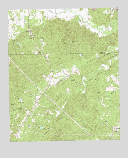
Burnt Hickory Ridge, GA USGS Topographic Map
Click on map above to begin viewing in our Map Viewer.

This topographic map contains these locations and features:
Feature Name Type Latitude Longitude GNIS ID View Map
Bartow County Fire Department Station 9BuildingN34.0964°W84.8465°2604293View Map
Benson LakeReservoirN34.0126°W84.8393°331137View Map
Browns LakeReservoirN34.0918°W84.8626°337117View Map
Burnt Hickory ChurchChurchN34.0451°W84.8341°354914View Map
Burnt Hickory Elementary schoolSchoolN34.0689°W84.8062°2546367View Map
Burnt Hickory FarmsPopulated PlaceN34.0529°W84.8222°349794View Map
Burnt Hickory RidgeLocaleN34.0262°W84.8519°312064View Map
Burnt Hickory Ridge EstatesPopulated PlaceN34.0387°W84.8330°349795View Map
Carnes LakeReservoirN34.0808°W84.7931°312347View Map
Cartersville AirportAirportN34.1231°W84.8500°351709View Map
Cedar RidgePopulated PlaceN34.0529°W84.7577°349801View Map
Conner LakeReservoirN34.1085°W84.8345°337115View Map
Cross Road FarmsPopulated PlaceN34.0154°W84.7666°349815View Map
Cross RoadsPopulated PlaceN34.0101°W84.7555°331481View Map
Cross Roads CemeteryCemeteryN34.0107°W84.7577°349814View Map
Cross Roads ChurchChurchN34.0107°W84.7569°334577View Map
Crossroads United Methodist ChurchChurchN34.0507°W84.7618°2740628View Map
CrowvillePopulated PlaceN34.0448°W84.7758°355394View Map
Dellinger LakeReservoirN34.0860°W84.8144°339384View Map
Dellinger Lake DamDamN34.0884°W84.8149°339383View Map
Douthit Family CemeteryCemeteryN34.1161°W84.8206°2358569View Map
Drum CreekStreamN34.0984°W84.8066°313630View Map
Dunaway BranchStreamN34.0273°W84.8197°313719View Map
Dunaway MineMineN34.0459°W84.8313°352874View Map
Emerson City CemeteryCemeteryN34.1233°W84.7580°2358609View Map
Emerson Elementary SchoolSchoolN34.1244°W84.7580°334273View Map
Etowah Valley Baptist Church CemeteryCemeteryN34.1189°W84.8561°2358669View Map
Etowah Valley ChurchChurchN34.1190°W84.8555°313979View Map
George H McMillan BridgeBridgeN34.0551°W84.7897°334583View Map
Goodwin BranchStreamN34.0637°W84.8055°314695View Map
Gourd BranchStreamN34.0920°W84.8022°314739View Map
Harmony Grove CemeteryCemeteryN34.0523°W84.7988°315151View Map
Harmony Grove ChurchChurchN34.0573°W84.8002°356192View Map
Hodges ProspectMineN34.0087°W84.8688°1705309View Map
Holly Spring BranchStreamN34.0929°W84.8038°315565View Map
Indian ValleyPopulated PlaceN34.1176°W84.8524°334293View Map
Little Pumpkinvine CreekStreamN34.0470°W84.7905°317153View Map
Lucas Family CemeteryCemeteryN34.1020°W84.8744°334306View Map
Marable CreekStreamN34.0673°W84.8727°317680View Map
McEvers BranchStreamN34.0612°W84.7763°317907View Map
Merritt MineMineN34.0412°W84.8380°352875View Map
Mount Moriah CemeteryCemeteryN34.0120°W84.8283°349883View Map
Mount Moriah ChurchChurchN34.0118°W84.8286°318702View Map
Mount View ChurchChurchN34.1043°W84.8491°318918View Map
Mountain Ridge EstatesPopulated PlaceN34.0979°W84.7574°334317View Map
Mountain View Church of God CemeteryCemeteryN34.1042°W84.8500°2359269View Map
Narroway CemeteryCemeteryN34.0320°W84.8613°349891View Map
Narroway ChurchChurchN34.0320°W84.8608°319206View Map
North Paulding DivisionCivilN34.0189°W84.8434°1936326View Map
North Paulding High SchoolSchoolN34.0735°W84.8069°2546388View Map
Oak HillPopulated PlaceN34.0070°W84.7635°349902View Map
ParkerosaPopulated PlaceN34.1001°W84.8466°334325View Map
Pathway ChurchChurchN34.0048°W84.7585°334596View Map
Paulding County Fire and Rescue Bureau Station 6BuildingN34.0249°W84.8538°2604564View Map
Paulding County Fire and Rescue Bureau Station 8BuildingN34.0072°W84.7509°2604569View Map
Picketts CreekPopulated PlaceN34.0307°W84.7510°349919View Map
Picketts Mill CreekStreamN34.0168°W84.7822°320479View Map
Pittman LakeReservoirN34.0928°W84.8032°320765View Map
Possum CreekStreamN34.0143°W84.7913°321080View Map
Pumpkinvine CreekStreamN34.1240°W84.8033°321232View Map
Pumpkinvine Creek Structure Number 16 DamDamN34.0151°W84.8399°335856View Map
Pumpkinvine Creek Structure Number One DamDamN34.0818°W84.7933°335846View Map
Pumpkinvine Creek Structure Number Two DamDamN34.0932°W84.8030°337128View Map
Racoon Creek Structure Number Eight DamDamN34.1084°W84.8349°337114View Map
Racoon Creek Structure Number Seven DamDamN34.0934°W84.8649°337116View Map
Raper CreekStreamN34.0057°W84.8216°321317View Map
Royal Oaks Golf CourseLocaleN34.0943°W84.8361°334341View Map
Russell MineMineN34.0293°W84.8541°352876View Map
Sammy McClure Middle SchoolSchoolN34.0697°W84.8094°2546389View Map
Sheffield-Heidt ProspectMineN34.0120°W84.8674°1705310View Map
Shelton Elementary SchoolSchoolN34.0247°W84.7764°2346423View Map
South Central Middle SchoolSchoolN34.1213°W84.7648°2545672View Map
Taylor LakeReservoirN34.1020°W84.8628°339382View Map
Taylor Lake DamDamN34.1018°W84.8633°339381View Map
Twilley MineMineN34.0223°W84.8624°1705311View Map
Valley Oak AcresPopulated PlaceN34.1240°W84.8608°334362View Map
Wade Chapel Holiness Church CemeteryCemeteryN34.1050°W84.8519°2363595View Map
Wades ChapelChurchN34.1048°W84.8511°324738View Map
Ward CreekStreamN34.1201°W84.8158°324836View Map
West Fork Pumpkinvine CreekStreamN34.0276°W84.8183°325050View Map
Westbrook CreekStreamN34.0704°W84.7630°325083View Map
WestforkPopulated PlaceN34.0048°W84.8374°349967View Map
Whitworth Memorial ChurchChurchN34.0084°W84.7541°325244View Map
Woodland High SchoolSchoolN34.1201°W84.8331°2545624View Map

Note: Coordinates in the location and feature list above are referenced to NAD83 datum.


Copyright (C) 2008-2025 Ryan Niemi / Sunset Dynamics ... All Rights Reserved