TopoQuest Logo
Do you find TopoQuest useful?
Help keep TopoQuest running and adding new maps/features by donating!
Bitcoin:  19c7KJd3qBynnjoSw5npx9KScwjBe4ifkT
Litecoin:  LXs6TkuXGGXo1vDsWCkWVdjQX94eUKd6ui
Home View Maps Find Maps Find Places Resources & Links


Taylorsville, Georgia Topographic Map

USGS Map Title: Taylorsville, GA
USGS Map MRC: 34084A8
DRG (GeoTIFF) Download: o34084a8.tif


Neighboring USGS Topographic Map Quads:


  Wax, GA  
34085B1
 

  Kingston, GA  
34084B8
 

  Cartersville, GA  
34084B7
 

  Rockmart North, GA  
34085A1
 

  Taylorsville, GA  
34084A8
 

  Burnt Hickory Ridge, GA  
34084A7
 

  Rockmart South, GA  
33085H1
 

  Yorkville, GA  
33084H8
 

  Dallas, GA  
33084H7


Map MRC Location:

N35°
W85°
N35°
W84°
H8 H7 H6 H5 H4 H3 H2 H1
G8 G7 G6 G5 G4 G3 G2 G1
F8 F7 F6 F5 F4 F3 F2 F1
E8 E7 E6 E5 E4 E3 E2 E1
D8 D7 D6 D5 D4 D3 D2 D1
C8 C7 C6 C5 C4 C3 C2 C1
B8 B7 B6 B5 B4 B3 B2 B1
A8 A7 A6 A5 A4 A3 A2 A1
N34°
W85°
N34°
W84°

Taylorsville, GA USGS 1:24K Topographic Map Preview:
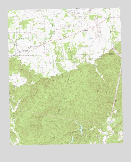
Taylorsville, GA USGS Topographic Map
Click on map above to begin viewing in our Map Viewer.

This topographic map contains these locations and features:
Feature Name Type Latitude Longitude GNIS ID View Map
Bartow County Fire Department Station 11BuildingN34.0864°W84.9883°2604316View Map
Braswell CornersPopulated PlaceN34.0087°W84.8763°349787View Map
Corley LakeReservoirN34.0139°W84.9229°312996View Map
Corley Lake DamDamN34.0148°W84.9191°335880View Map
Cornerstone ChurchChurchN34.0795°W84.9269°1705473View Map
Cross TrailsLocaleN34.0429°W84.9405°313170View Map
Don (historical)Populated PlaceN34.0009°W84.9977°1705472View Map
Euharlee ChurchChurchN34.0543°W84.9933°313986View Map
Floyd CreekStreamN34.1043°W84.9513°313658View Map
Floyd Creek ChurchChurchN34.0762°W84.9263°355858View Map
Forked BranchStreamN34.0570°W84.9744°314277View Map
Hills CreekStreamN34.0982°W84.9569°356305View Map
Iron StabPopulated PlaceN34.0354°W84.9436°332067View Map
Jackson CreekStreamN34.0984°W84.8863°316011View Map
Jones BranchStreamN34.1148°W84.9530°316207View Map
Left Prong Pegamore CreekStreamN34.0087°W84.9224°316752View Map
Mackey BranchStreamN34.0689°W84.9519°317582View Map
McGinnis (historical)Populated PlaceN34.0976°W84.9552°1705469View Map
Middle Prong Pegamore CreekStreamN34.0126°W84.9266°318087View Map
Mineral Spring BranchStreamN34.0701°W84.9499°318312View Map
Mount Sinai ChurchChurchN34.0698°W84.9874°356406View Map
Mount Zion Cemetery (Old)CemeteryN34.1161°W84.9450°2367731View Map
Murry CreekStreamN34.0404°W84.8847°319169View Map
Old Salem GraveyardCemeteryN34.1005°W84.9983°2359789View Map
Pegamore CreekStreamN34.0126°W84.8955°320345View Map
Pegamore LakeReservoirN34.0036°W84.9317°320346View Map
Pegamore Lake DamDamN34.0068°W84.9313°336099View Map
Pine MountainSummitN34.0484°W84.9033°332675View Map
Popham BranchStreamN34.0719°W84.9506°321022View Map
Raccoon Creek Baptist Church CemeteryCemeteryN34.1164°W84.8864°2359709View Map
Raccoon Creek ChurchChurchN34.1162°W84.8858°321269View Map
Right Prong Pegamore CreekStreamN34.0207°W84.9263°321608View Map
Shiloh Missionary Baptist Church CemeteryCemeteryN34.1089°W84.9231°2363229View Map
Sproull Family CemeteryCemeteryN34.0994°W84.9389°2363290View Map
Stidham-Henderson CemeteryCemeteryN34.1042°W84.8994°2363349View Map
StilesboroPopulated PlaceN34.1048°W84.9158°356563View Map
Stilesboro Methodist Church CemeteryCemeteryN34.1150°W84.9211°2363389View Map
TaylorsvillePopulated PlaceN34.0862°W84.9874°323966View Map
Taylorsville Church Cemetery (Old)CemeteryN34.0828°W84.9894°2363469View Map
Taylorsville Elementary SchoolSchoolN34.1101°W84.9410°323967View Map
Town of TaylorsvilleCivilN34.0860°W84.9876°2406718View Map
Winkley BranchStreamN34.0687°W84.9511°325454View Map
WTSH-FM (Rockmart)TowerN34.1015°W84.9930°352760View Map

Note: Coordinates in the location and feature list above are referenced to NAD83 datum.


Copyright (C) 2008-2025 Ryan Niemi / Sunset Dynamics ... All Rights Reserved