TopoQuest Logo
Do you find TopoQuest useful?
Help keep TopoQuest running and adding new maps/features by donating!
Bitcoin:  19c7KJd3qBynnjoSw5npx9KScwjBe4ifkT
Litecoin:  LXs6TkuXGGXo1vDsWCkWVdjQX94eUKd6ui
Home View Maps Find Maps Find Places Resources & Links


Kingston, Georgia Topographic Map

USGS Map Title: Kingston, GA
USGS Map MRC: 34084B8
DRG (GeoTIFF) Download: o34084b8.tif


Neighboring USGS Topographic Map Quads:


  Shannon, GA  
34085C1
 

  Adairsville, GA  
34084C8
 

  White West, GA  
34084C7
 

  Wax, GA  
34085B1
 

  Kingston, GA  
34084B8
 

  Cartersville, GA  
34084B7
 

  Rockmart North, GA  
34085A1
 

  Taylorsville, GA  
34084A8
 

  Burnt Hickory Ridge, GA  
34084A7


Map MRC Location:

N35°
W85°
N35°
W84°
H8 H7 H6 H5 H4 H3 H2 H1
G8 G7 G6 G5 G4 G3 G2 G1
F8 F7 F6 F5 F4 F3 F2 F1
E8 E7 E6 E5 E4 E3 E2 E1
D8 D7 D6 D5 D4 D3 D2 D1
C8 C7 C6 C5 C4 C3 C2 C1
B8 B7 B6 B5 B4 B3 B2 B1
A8 A7 A6 A5 A4 A3 A2 A1
N34°
W85°
N34°
W84°

Kingston, GA USGS 1:24K Topographic Map Preview:
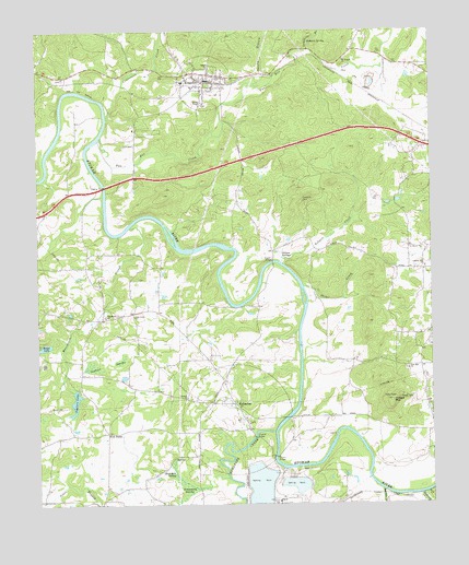
Kingston, GA USGS Topographic Map
Click on map above to begin viewing in our Map Viewer.

This topographic map contains these locations and features:
Feature Name Type Latitude Longitude GNIS ID View Map
Arnold CemeteryCemeteryN34.1844°W84.9681°2357429View Map
Ashpole CreekStreamN34.1890°W84.9222°310647View Map
Aylmer (historical)Populated PlaceN34.1918°W84.9252°334231View Map
Bartow County Fire Department Station 12BuildingN34.1865°W84.8787°2604964View Map
Bests Station (historical)LocaleN34.2432°W84.9144°334237View Map
Black Pioneers CemeteryCemeteryN34.1473°W84.9338°2358029View Map
Blue Hole SpringSpringN34.1343°W84.9577°311548View Map
Brandon Family CemeteryCemeteryN34.1344°W84.9150°2358049View Map
Brookshire Family CemeteryCemeteryN34.2219°W84.8761°2358069View Map
Burge Family CemeteryCemeteryN34.1433°W84.9067°2358191View Map
Church of the Lord Jesus Christ CemeteryCemeteryN34.2286°W84.9606°2358330View Map
City of EuharleeCivilN34.1441°W84.9327°2403576View Map
City of KingstonCivilN34.2320°W84.9445°2404837View Map
Confederate Cemetery in KingstonCemeteryN34.2300°W84.9461°2359390View Map
Connesena CreekStreamN34.2273°W84.9772°312904View Map
Corinth ChurchChurchN34.1532°W84.9527°312990View Map
Drummer Swamp CemeteryCemeteryN34.1354°W84.9591°334270View Map
Drummond SwampSwampN34.1295°W84.9536°313632View Map
Etowah Bend GliderportAirportN34.2022°W84.9769°351813View Map
Etowah FieldsAirportN34.1756°W84.9235°2442633View Map
EuharleePopulated PlaceN34.1448°W84.9330°313985View Map
Euharlee Baptist Church CemeteryCemeteryN34.1464°W84.9330°2358689View Map
Euharlee CreekStreamN34.1443°W84.9252°313987View Map
Euharlee Elementary SchoolSchoolN34.1501°W84.9281°2346518View Map
Euharlee Fire DepartmentBuildingN34.1519°W84.9372°2604065View Map
Euharlee Police DepartmentBuildingN34.1473°W84.9368°2734019View Map
Euharlee Presbyterian Church CemeteryCemeteryN34.1481°W84.9342°2358690View Map
Euharlee-Taylorsville DivisionCivilN34.1418°W84.9775°1936254View Map
Five ForksLocaleN34.1440°W84.9780°326280View Map
Ford (historical)Populated PlaceN34.1890°W84.9661°334279View Map
Gillam SpringsSpringN34.1904°W84.9205°314597View Map
Harden BridgeBridgeN34.1890°W84.9247°315114View Map
Hodge LakeLakeN34.1668°W84.9977°315481View Map
Hodge MountainSummitN34.1523°W84.8874°315482View Map
Island FordCrossingN34.1962°W84.9580°334296View Map
KingstonPopulated PlaceN34.2370°W84.9441°332152View Map
Kingston Baptist ChurchChurchN34.2351°W84.9438°334301View Map
Kingston ChurchChurchN34.2284°W84.9605°334302View Map
Kingston City CemeteryCemeteryN34.2300°W84.9461°2359389View Map
Kingston Elementary SchoolSchoolN34.2137°W84.9358°334303View Map
Kingston Fire DepartmentBuildingN34.2356°W84.9479°2604679View Map
Kingston Police DepartmentBuildingN34.2356°W84.9479°2733781View Map
Liberty Hill ChurchChurchN34.1876°W84.8766°316841View Map
Limekiln BranchStreamN34.2448°W84.9124°316873View Map
Macedonia Baptist Church 1847 Cemetery (Old)CemeteryN34.1744°W84.9892°2367389View Map
Macedonia Baptist Church CemeteryCemeteryN34.1747°W84.9792°2367409View Map
Macedonia ChurchChurchN34.1745°W84.9786°356375View Map
Macedonia SloughStreamN34.1984°W84.9699°317579View Map
Malbone (historical)Populated PlaceN34.1432°W84.8972°334307View Map
Milams BridgeBridgeN34.1376°W84.9249°318144View Map
Mission Road Elementary SchoolSchoolN34.1622°W84.8798°334314View Map
Mount Pisgah Baptist CemeteryCemeteryN34.2425°W84.9019°2359217View Map
Mount Pisgah ChurchChurchN34.2423°W84.9016°356403View Map
New Vision Baptist ChurchChurchN34.2197°W84.8864°2746898View Map
Oak Grove ChurchChurchN34.1743°W84.9694°319813View Map
Oak Grove United Methodist Church CemeteryCemeteryN34.1744°W84.9694°2359429View Map
Queens ChapelChurchN34.2307°W84.9455°321250View Map
Raccoon CreekStreamN34.1290°W84.8913°321267View Map
Reynolds BridgeBridgeN34.2087°W84.9786°334333View Map
Reynolds Family CemeteryCemeteryN34.2242°W84.9683°2359729View Map
Reynolds School (historical)SchoolN34.2032°W84.9969°334334View Map
Richland CreekStreamN34.1276°W84.8791°321580View Map
Rodgers SpringSpringN34.2470°W84.9122°321866View Map
Shanty BranchStreamN34.2362°W84.9294°322778View Map
Shellman (historical)Populated PlaceN34.1270°W84.8866°334347View Map
Shiloh ChurchChurchN34.2409°W84.9436°322898View Map
Stiles CreekStreamN34.1823°W84.9152°323612View Map
Styles CemeteryCemeteryN34.1370°W84.8933°334353View Map
Taylors LakeReservoirN34.1526°W84.9882°323963View Map
Taylors Lake DamDamN34.1532°W84.9877°337118View Map
Taylors SwampSwampN34.1617°W84.9829°323965View Map
Tidwell LakeReservoirN34.1889°W84.8978°339396View Map
Tidwell Lake DamDamN34.1884°W84.8983°339395View Map
Two Run CreekStreamN34.2220°W84.9791°356603View Map
Woodland Middle SchoolSchoolN34.1464°W84.9291°2346442View Map
Wooley Family CemeteryCemeteryN34.2375°W84.9914°2363631View Map
Woollys (historical)Populated PlaceN34.2381°W84.9930°334372View Map
Zion Hill Baptist Church CemeteryCemeteryN34.1605°W84.8831°2363651View Map
Zion Hill ChurchChurchN34.1604°W84.8824°325701View Map

Note: Coordinates in the location and feature list above are referenced to NAD83 datum.


Copyright (C) 2008-2024 Ryan Niemi / Sunset Dynamics ... All Rights Reserved