TopoQuest Logo
Do you find TopoQuest useful?
Help keep TopoQuest running and adding new maps/features by donating!
Bitcoin:  19c7KJd3qBynnjoSw5npx9KScwjBe4ifkT
Litecoin:  LXs6TkuXGGXo1vDsWCkWVdjQX94eUKd6ui
Home View Maps Find Maps Find Places Resources & Links


Burnt Peak, California Topographic Map

USGS Map Title: Burnt Peak, CA
USGS Map MRC: 34118F5
DRG (GeoTIFF) Download: o34118f5.tif


Neighboring USGS Topographic Map Quads:


  La Liebre Ranch, CA  
34118G6
 

  Neenach School, CA  
34118G5
 

  Fairmont Butte, CA  
34118G4
 

  Liebre Mountain, CA  
34118F6
 

  Burnt Peak, CA  
34118F5
 

  Lake Hughes, CA  
34118F4
 

  Whitaker Peak, CA  
34118E6
 

  Warm Springs Mountain, CA  
34118E5
 

  Green Valley, CA  
34118E4


Map MRC Location:

N35°
W119°
N35°
W118°
H8 H7 H6 H5 H4 H3 H2 H1
G8 G7 G6 G5 G4 G3 G2 G1
F8 F7 F6 F5 F4 F3 F2 F1
E8 E7 E6 E5 E4 E3 E2 E1
D8 D7 D6 D5 D4 D3 D2 D1
C8 C7 C6 C5 C4 C3 C2 C1
B8 B7 B6 B5 B4 B3 B2 B1
A8 A7 A6 A5 A4 A3 A2 A1
N34°
W119°
N34°
W118°

Burnt Peak, CA USGS 1:24K Topographic Map Preview:
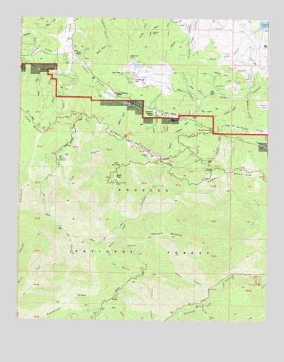
Burnt Peak, CA USGS Topographic Map
Click on map above to begin viewing in our Map Viewer.

This topographic map contains these locations and features:
Feature Name Type Latitude Longitude GNIS ID View Map
Antimony CanyonValleyN34.7178°W118.5187°238650View Map
Atmore MeadowsFlatN34.6914°W118.6054°238820View Map
Atmore Meadows CampgroundLocaleN34.6919°W118.6051°1655300View Map
Big Chief MineMineN34.7439°W118.5590°239280View Map
Bleich FlatFlatN34.7261°W118.5106°239473View Map
Burnt PeakSummitN34.6825°W118.5768°239871View Map
Burnt Peak CanyonValleyN34.6505°W118.5970°239872View Map
Burnt Peak TrailTrailN34.6614°W118.5781°239873View Map
Bushnell SummitGapN34.7036°W118.5281°239899View Map
Cottonwood CampgroundLocaleN34.6403°W118.5048°240970View Map
Deadhorse CanyonValleyN34.7255°W118.5184°241318View Map
Deer LodgeLocaleN34.7272°W118.5743°241370View Map
Devils GulchValleyN34.7111°W118.5565°241467View Map
Fish Canyon TrailTrailN34.6672°W118.6084°242268View Map
Fish CreekStreamN34.6422°W118.5220°242269View Map
Garden GulchValleyN34.7286°W118.6154°242604View Map
Gillette Mine TrailTrailN34.6836°W118.6137°242709View Map
Heryford CanyonValleyN34.7094°W118.5490°243388View Map
Hidden LakeLakeN34.7087°W118.5471°243417View Map
Hidden Lake RanchLocaleN34.7086°W118.5487°243419View Map
Hideaway CanyonValleyN34.7100°W118.5393°243434View Map
Kimbrough CanyonValleyN34.7366°W118.6168°271894View Map
Kings Canyon Percolation BasinReservoirN34.7477°W118.5015°1802848View Map
Kings Canyon RanchLocaleN34.7191°W118.5304°244317View Map
Lion CanyonValleyN34.6511°W118.5834°244882View Map
Little Burnt PeakSummitN34.6889°W118.5765°1660922View Map
Lower Shake CampgroundLocaleN34.6992°W118.5251°245273View Map
Maxwell MineMineN34.6555°W118.5706°245608View Map
McCorkle CanyonValleyN34.7183°W118.5123°245655View Map
North Fork Fish CanyonValleyN34.6947°W118.5895°246607View Map
North Long CanyonValleyN34.7422°W118.5151°246643View Map
Oak FlatFlatN34.7211°W118.6040°246720View Map
Oakdale CanyonValleyN34.7369°W118.6031°272758View Map
Oakgrove CanyonValleyN34.7372°W118.6001°246767View Map
Pine Canyon Ranger StationLocaleN34.6989°W118.5109°247491View Map
Pine Canyon SchoolSchoolN34.7344°W118.5993°1669897View Map
Pine StoreLocaleN34.7483°W118.5990°1669898View Map
Pratt CanyonValleyN34.7366°W118.6031°247769View Map
Red Fox CanyonValleyN34.6311°W118.5343°248041View Map
Redrock CanyonValleyN34.7386°W118.5815°248095View Map
Sand CanyonValleyN34.7128°W118.5359°248984View Map
Sawmill CampgroundLocaleN34.7011°W118.5720°249172View Map
Sawmill CanyonValleyN34.7139°W118.5748°249174View Map
Sawmill MountainSummitN34.6933°W118.5609°249179View Map
Sawmill Mountain RanchLocaleN34.7180°W118.5784°249180View Map
Sawtooth MountainSummitN34.6605°W118.5523°249186View Map
Schumacher PointSummitN34.7339°W118.5701°1661413View Map
Shake CanyonValleyN34.7017°W118.5237°249339View Map
South Long CanyonValleyN34.7350°W118.5043°249740View Map
Spring CanyonValleyN34.7180°W118.5329°249813View Map
The PotholesBasinN34.6728°W118.5056°250406View Map
Three PointsPopulated PlaceN34.7358°W118.5987°1655024View Map
Timberline Meadows ResortLocaleN34.7108°W118.5576°277004View Map
Turkey CanyonValleyN34.6342°W118.5298°250708View Map
Tweedy LakeLakeN34.7307°W118.5677°250723View Map
Tweedy Lake ClubLocaleN34.7261°W118.5673°250724View Map
Upper Shake CampgroundLocaleN34.6914°W118.5298°250856View Map

Note: Coordinates in the location and feature list above are referenced to NAD83 datum.


Copyright (C) 2008-2025 Ryan Niemi / Sunset Dynamics ... All Rights Reserved