TopoQuest Logo
Do you find TopoQuest useful?
Help keep TopoQuest running and adding new maps/features by donating!
Bitcoin:  19c7KJd3qBynnjoSw5npx9KScwjBe4ifkT
Litecoin:  LXs6TkuXGGXo1vDsWCkWVdjQX94eUKd6ui
Home View Maps Find Maps Find Places Resources & Links


Almena, Wisconsin Topographic Map

USGS Map Title: Almena, WI
USGS Map MRC: 45092D1
DRG (GeoTIFF) Download: o45092d1.tif


Neighboring USGS Topographic Map Quads:


  McKinley, WI  
45092E2
 

  Cumberland, WI  
45092E1
 

  Lower Vermillion Lake, WI  
45091E8
 

  Turtle Lake, WI  
45092D2
 

  Almena, WI  
45092D1
 

  Poskin, WI  
45091D8
 

  Clayton, WI  
45092C2
 

  Arland, WI  
45092C1
 

  Dorrity Creek, WI  
45091C8


Map MRC Location:

N46°
W93°
N46°
W92°
H8 H7 H6 H5 H4 H3 H2 H1
G8 G7 G6 G5 G4 G3 G2 G1
F8 F7 F6 F5 F4 F3 F2 F1
E8 E7 E6 E5 E4 E3 E2 E1
D8 D7 D6 D5 D4 D3 D2 D1
C8 C7 C6 C5 C4 C3 C2 C1
B8 B7 B6 B5 B4 B3 B2 B1
A8 A7 A6 A5 A4 A3 A2 A1
N45°
W93°
N45°
W92°

Almena, WI USGS 1:24K Topographic Map Preview:
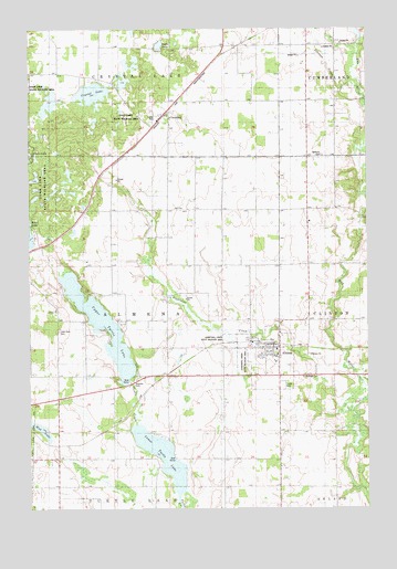
Almena, WI USGS Topographic Map
Click on map above to begin viewing in our Map Viewer.

This topographic map contains these locations and features:
Feature Name Type Latitude Longitude GNIS ID View Map
AlmenaPopulated PlaceN45.4169°W92.0330°1560800View Map
Almena - Clinton - Arland Fire DistrictBuildingN45.4183°W92.0409°2696907View Map
Almena Elementary SchoolSchoolN45.4163°W92.0338°1837867View Map
Backroad DairyLocaleN45.4594°W92.0139°2664062View Map
Bethany CemeteryCemeteryN45.4669°W92.0164°1561615View Map
Bethany Church (historical)ChurchN45.4661°W92.0238°1837884View Map
Bethany Valley FarmsLocaleN45.4608°W92.0303°2664063View Map
Castelle FarmLocaleN45.4053°W92.0936°2664057View Map
Clinton Heights School (historical)SchoolN45.3947°W92.0121°1837895View Map
ComstockPopulated PlaceN45.4777°W92.0752°1563304View Map
Corey School (historical)SchoolN45.4533°W92.0113°1837901View Map
Crystal LakeLakeN45.4829°W92.1015°1563587View Map
Crystal Lake CemeteryCemeteryN45.4777°W92.0759°1988532View Map
Finley School (historical)SchoolN45.4816°W92.0213°1837923View Map
Gates LakeLakeN45.4955°W92.0767°1565442View Map
Gospel Mennonite SchoolSchoolN45.4500°W92.0212°2713322View Map
Hay River Valley School (historical)SchoolN45.4236°W92.0080°1837944View Map
Johnson CreekStreamN45.4861°W92.0030°1567214View Map
Lake View CemeteryCemeteryN45.4213°W92.1143°1567757View Map
Lightning CreekStreamN45.4002°W92.0055°1568032View Map
Lightning Creek State Wildlife AreaParkN45.4191°W92.0518°1568033View Map
Lower Turtle LakeLakeN45.3887°W92.0763°1568758View Map
Maple Grove School (historical)SchoolN45.4527°W92.0655°1837968View Map
Midway School (historical)SchoolN45.4172°W92.0738°1837971View Map
Mud LakeLakeN45.3958°W92.1214°1569998View Map
Perley ChurchChurchN45.4269°W92.1155°1571227View Map
Sacred Heart CemeteryCemeteryN45.4192°W92.0396°1988878View Map
Sacred Heart of Jesus ChurchChurchN45.4177°W92.0374°1988853View Map
Saint Matthew Lutheran CemeteryCemeteryN45.4099°W92.0239°1573353View Map
Saint Matthew Lutheran ChurchChurchN45.4152°W92.0335°1988854View Map
Sprague School (historical)SchoolN45.4955°W92.0518°1838017View Map
Town of AlmenaCivilN45.4264°W92.0927°1582680View Map
Upper Turtle LakeLakeN45.4226°W92.0985°1575997View Map
Village of AlmenaCivilN45.4149°W92.0382°1582679View Map
Zion Lutheran CemeteryCemeteryN45.4525°W92.0685°1988544View Map
Zion Lutheran ChurchChurchN45.4533°W92.0688°1577169View Map

Note: Coordinates in the location and feature list above are referenced to NAD83 datum.


Copyright (C) 2008-2024 Ryan Niemi / Sunset Dynamics ... All Rights Reserved