TopoQuest Logo
Do you find TopoQuest useful?
Help keep TopoQuest running and adding new maps/features by donating!
Bitcoin:  19c7KJd3qBynnjoSw5npx9KScwjBe4ifkT
Litecoin:  LXs6TkuXGGXo1vDsWCkWVdjQX94eUKd6ui
Home View Maps Find Maps Find Places Resources & Links


Caldwell Lake, Wyoming Topographic Map

USGS Map Title: Caldwell Lake, WY
USGS Map MRC: 41105B7
DRG (GeoTIFF) Download: o41105b7.tif


Neighboring USGS Topographic Map Quads:


  Millbrook, WY  
41105C8
 

  Miller, WY  
41105C7
 

  Laramie SW, WY  
41105C6
 

  Sodergreen Lake, WY  
41105B8
 

  Caldwell Lake, WY  
41105B7
 

  Hutton Lake, WY  
41105B6
 

  Jelm Mountain, WY  
41105A8
 

  Downey Lakes, WY  
41105A7
 

  Johnson Ranch, WY  
41105A6


Map MRC Location:

N42°
W106°
N42°
W105°
H8 H7 H6 H5 H4 H3 H2 H1
G8 G7 G6 G5 G4 G3 G2 G1
F8 F7 F6 F5 F4 F3 F2 F1
E8 E7 E6 E5 E4 E3 E2 E1
D8 D7 D6 D5 D4 D3 D2 D1
C8 C7 C6 C5 C4 C3 C2 C1
B8 B7 B6 B5 B4 B3 B2 B1
A8 A7 A6 A5 A4 A3 A2 A1
N41°
W106°
N41°
W105°

Caldwell Lake, WY USGS 1:24K Topographic Map Preview:
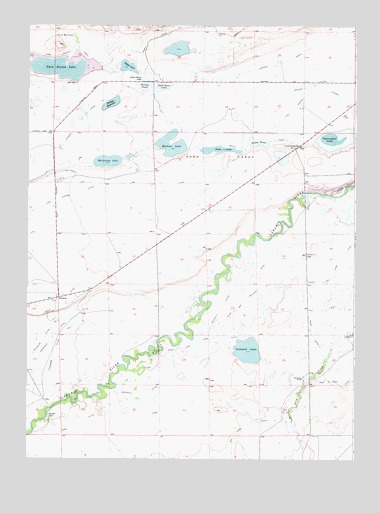
Caldwell Lake, WY USGS Topographic Map
Click on map above to begin viewing in our Map Viewer.

This topographic map contains these locations and features:
Feature Name Type Latitude Longitude GNIS ID View Map
Bush and Holliday DitchCanalN41.1816°W105.7844°1586192View Map
Bush DitchCanalN41.1594°W105.7658°1586197View Map
Caldwell DitchCanalN41.1444°W105.8308°1586273View Map
Caldwell LakeLakeN41.1564°W105.7910°1586274View Map
Gelatt LakeLakeN41.2381°W105.8373°1588851View Map
Gibbs PondLakeN41.2165°W105.7873°1588892View Map
Haley and Hoge DitchCanalN41.1608°W105.7931°1589242View Map
Harman DamDamN41.2083°W105.8022°1605807View Map
Harman ReservoirReservoirN41.2069°W105.8031°1605808View Map
HarmonyPopulated PlaceN41.1716°W105.8633°1589316View Map
Hunzicker RanchLocaleN41.1483°W105.7703°1589826View Map
King DitchCanalN41.1314°W105.8656°1600724View Map
Lake Hattie CanalCanalN41.2419°W105.8719°1600801View Map
Lake MildredLakeN41.2183°W105.7506°1584665View Map
Last Chance DitchCanalN41.1978°W105.8694°1600848View Map
Leroy BridgeLocaleN41.1561°W105.8250°1590647View Map
Little Gelatt LakeLakeN41.2344°W105.8302°1590800View Map
Mansfield DitchCanalN41.1544°W105.8706°1601249View Map
Meeboer LakeLakeN41.2138°W105.8210°1591453View Map
Mortenson LakeLakeN41.2109°W105.8449°1591774View Map
Mortenson Lake National Wildlife RefugeParkN41.2116°W105.8088°2765411View Map
Nelson PondLakeN41.2326°W105.8310°1592006View Map
Osterman LakeLakeN41.2324°W105.8239°1592495View Map
Phillips ReservoirReservoirN41.2276°W105.8435°1592722View Map
Riverside Ditch Number 1CanalN41.1533°W105.8664°1605452View Map
Riverside RanchLocaleN41.1372°W105.8667°1593488View Map
Sand Creek MineMineN41.1280°W105.7764°1726220View Map
Soda LakeLakeN41.2143°W105.8025°1594546View Map
Soda Lake Draw Number 1 DamDamN41.2150°W105.8089°1605805View Map
Soda Lake Draw Number 1 ReservoirReservoirN41.2143°W105.8025°1605806View Map
South CanalCanalN41.2191°W105.8125°1596911View Map
Twelvemile HillSummitN41.2150°W105.7761°1595750View Map
Twelvemile LakeLakeN41.2175°W105.7595°1595753View Map
Twin Buttes LakeLakeN41.2380°W105.8617°1595782View Map

Note: Coordinates in the location and feature list above are referenced to NAD83 datum.


Copyright (C) 2008-2025 Ryan Niemi / Sunset Dynamics ... All Rights Reserved