TopoQuest Logo
Do you find TopoQuest useful?
Help keep TopoQuest running and adding new maps/features by donating!
Bitcoin:  19c7KJd3qBynnjoSw5npx9KScwjBe4ifkT
Litecoin:  LXs6TkuXGGXo1vDsWCkWVdjQX94eUKd6ui
Home View Maps Find Maps Find Places Resources & Links


Downey Lakes, Wyoming Topographic Map

USGS Map Title: Downey Lakes, WY
USGS Map MRC: 41105A7
DRG (GeoTIFF) Download: o41105a7.tif


Neighboring USGS Topographic Map Quads:


  Sodergreen Lake, WY  
41105B8
 

  Caldwell Lake, WY  
41105B7
 

  Hutton Lake, WY  
41105B6
 

  Jelm Mountain, WY  
41105A8
 

  Downey Lakes, WY  
41105A7
 

  Johnson Ranch, WY  
41105A6
 

  Crazy Mountain, CO  
40105H8
 

  Sand Creek Pass, CO  
40105H7
 

  Eaton Reservoir, CO  
40105H6


Map MRC Location:

N42°
W106°
N42°
W105°
H8 H7 H6 H5 H4 H3 H2 H1
G8 G7 G6 G5 G4 G3 G2 G1
F8 F7 F6 F5 F4 F3 F2 F1
E8 E7 E6 E5 E4 E3 E2 E1
D8 D7 D6 D5 D4 D3 D2 D1
C8 C7 C6 C5 C4 C3 C2 C1
B8 B7 B6 B5 B4 B3 B2 B1
A8 A7 A6 A5 A4 A3 A2 A1
N41°
W106°
N41°
W105°

Downey Lakes, WY USGS 1:24K Topographic Map Preview:
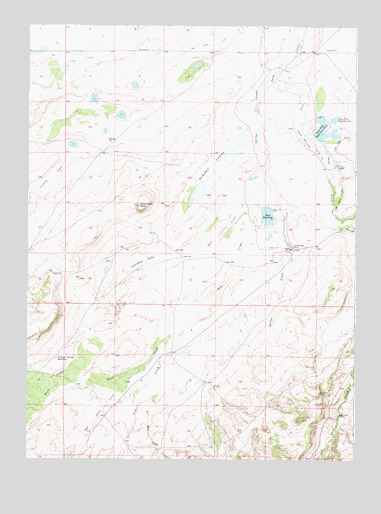
Downey Lakes, WY USGS Topographic Map
Click on map above to begin viewing in our Map Viewer.

This topographic map contains these locations and features:
Feature Name Type Latitude Longitude GNIS ID View Map
Bull Run CreekStreamN41.0155°W105.8328°170083View Map
Davis Brothers Ditch Number 1CanalN41.0905°W105.7694°1605242View Map
Downey LakesLakeN41.0875°W105.7985°1587760View Map
Dry CreekStreamN41.0811°W105.7856°170082View Map
East Shell CreekStreamN41.0247°W105.8337°170081View Map
Lindsey CreekStreamN41.0864°W105.8589°1590706View Map
Lone Tree DitchCanalN41.0883°W105.7572°1590950View Map
Lone Tree Number 1 DamDamN41.0966°W105.7606°1605660View Map
Lone Tree Reservoir Number 2ReservoirN41.0954°W105.7638°1605360View Map
Lone Tree Reservoir Number OneReservoirN41.0982°W105.7588°1605359View Map
Middle Downey Lake MineMineN41.0841°W105.7958°1726228View Map
North Downey Lake MineMineN41.0922°W105.7922°1726229View Map
Rice ReservoirReservoirN41.0705°W105.7840°1593423View Map
Riverside Ranch MineMineN41.0991°W105.7711°1726230View Map
Shell CreekStreamN41.0811°W105.7855°170080View Map
South Downey Lake MineMineN41.0775°W105.8100°1726231View Map
Spring CreekStreamN41.1116°W105.7817°1594823View Map
Spring Creek RanchLocaleN41.0616°W105.7750°1594888View Map
Steamboat LakeLakeN41.0568°W105.8343°1595002View Map
Steamboat RockSummitN41.0733°W105.8331°1595010View Map
Stink CreekStreamN41.0316°W105.8517°170085View Map
Trapper Spring ReservoirReservoirN41.0291°W105.8641°1595689View Map

Note: Coordinates in the location and feature list above are referenced to NAD83 datum.


Copyright (C) 2008-2024 Ryan Niemi / Sunset Dynamics ... All Rights Reserved