TopoQuest Logo
Do you find TopoQuest useful?
Help keep TopoQuest running and adding new maps/features by donating!
Bitcoin:  19c7KJd3qBynnjoSw5npx9KScwjBe4ifkT
Litecoin:  LXs6TkuXGGXo1vDsWCkWVdjQX94eUKd6ui
Home View Maps Find Maps Find Places Resources & Links


Caldwell North, Ohio Topographic Map

USGS Map Title: Caldwell North, OH
USGS Map MRC: 39081G5
DRG (GeoTIFF) Download: o39081g5.tif


Neighboring USGS Topographic Map Quads:


  New Concord, OH  
39081H6
 

  Byesville, OH  
39081H5
 

  Senecaville, OH  
39081H4
 

  Cumberland, OH  
39081G6
 

  Caldwell North, OH  
39081G5
 

  Sarahsville, OH  
39081G4
 

  Reinersville, OH  
39081F6
 

  Caldwell South, OH  
39081F5
 

  Macksburg, OH  
39081F4


Map MRC Location:

N40°
W82°
N40°
W81°
H8 H7 H6 H5 H4 H3 H2 H1
G8 G7 G6 G5 G4 G3 G2 G1
F8 F7 F6 F5 F4 F3 F2 F1
E8 E7 E6 E5 E4 E3 E2 E1
D8 D7 D6 D5 D4 D3 D2 D1
C8 C7 C6 C5 C4 C3 C2 C1
B8 B7 B6 B5 B4 B3 B2 B1
A8 A7 A6 A5 A4 A3 A2 A1
N39°
W82°
N39°
W81°

Caldwell North, OH USGS 1:24K Topographic Map Preview:
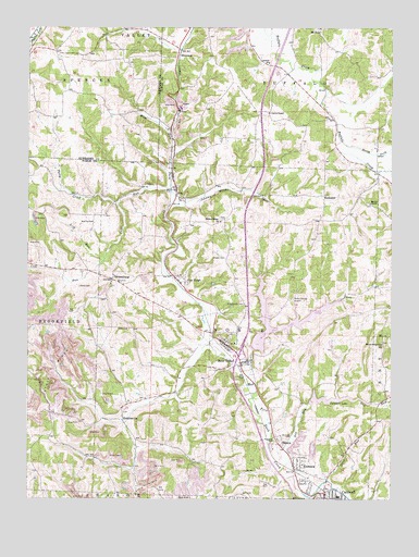
Caldwell North, OH USGS Topographic Map
Click on map above to begin viewing in our Map Viewer.

This topographic map contains these locations and features:
Feature Name Type Latitude Longitude GNIS ID View Map
Ackley School (historical)SchoolN39.7681°W81.5204°1050950View Map
AvaPopulated PlaceN39.8317°W81.5748°1056972View Map
Ava Post OfficePost OfficeN39.8320°W81.5748°2041287View Map
Baker School (historical)SchoolN39.7665°W81.6173°1050942View Map
Barrys Ridge CemeteryCemeteryN39.7915°W81.5032°1963668View Map
Barrys Ridge ChurchChurchN39.7915°W81.5032°1037654View Map
Belle ValleyPopulated PlaceN39.7906°W81.5562°1064405View Map
Belle Valley Post OfficePost OfficeN39.7904°W81.5568°2041509View Map
Belle Valley Volunteer Fire and RescueBuildingN39.7897°W81.5538°2549685View Map
Bethel ChapelChurchN39.8281°W81.5073°1037919View Map
Bethel Chapel CemeteryCemeteryN39.8278°W81.5071°1963670View Map
Bond Ridge School (historical)SchoolN39.7923°W81.5257°1050951View Map
Buffalo SchoolSchoolN39.8656°W81.5426°1038500View Map
Caldwell High SchoolSchoolN39.7506°W81.5179°1050955View Map
Caldwell LakeReservoirN39.7751°W81.5282°1078854View Map
Caldwell Lake DamDamN39.7757°W81.5275°1078853View Map
Central Ohio Coal Company Nb-151 DamDamN39.7801°W81.6148°1079402View Map
Central Ohio Coal Company Nb-151 ReservoirReservoirN39.7796°W81.6146°1079403View Map
Cherry Tree TrailTrailN39.7931°W81.5346°1962897View Map
Clark School (historical)SchoolN39.8523°W81.5421°1050948View Map
Clarks ChapelChurchN39.8523°W81.5423°1039142View Map
Coal RidgePopulated PlaceN39.8079°W81.5735°1060979View Map
Coal RunStreamN39.8315°W81.5765°1039209View Map
Coalridge Post Office (historical)Post OfficeN39.8084°W81.5735°2041254View Map
Dog RunStreamN39.7601°W81.5346°1039736View Map
Dumfertle School (historical)SchoolN39.8520°W81.5023°1050954View Map
Eastern Ohio Research Development Center PondReservoirN39.7913°W81.5207°1077786View Map
Emanuel Church (historical)ChurchN39.7662°W81.5873°1050941View Map
FlorencePopulated PlaceN39.7579°W81.5312°1064658View Map
Fowler CemeteryCemeteryN39.8145°W81.5612°1040626View Map
Garvin School (historical)SchoolN39.8695°W81.6140°1054680View Map
GlenwoodPopulated PlaceN39.8673°W81.5740°1064734View Map
Glenwood Post Office (historical)Post OfficeN39.8667°W81.5740°2041263View Map
Halleys Ridge CemeteryCemeteryN39.8242°W81.5587°1963679View Map
Halleys Ridge ChurchChurchN39.8237°W81.5590°1041251View Map
HiramsburgPopulated PlaceN39.8084°W81.5957°1056336View Map
Hiramsburg CemeteryCemeteryN39.8078°W81.5932°1963681View Map
Hiramsburg Post Office (historical)Post OfficeN39.8079°W81.5957°2041175View Map
Hog Ridge School (historical)SchoolN39.8723°W81.5629°1050949View Map
Holly Ridge School (historical)SchoolN39.8231°W81.5598°1050947View Map
HoskinsvillePopulated PlaceN39.7712°W81.5921°1064867View Map
Hoskinsville Post Office (historical)Post OfficeN39.7709°W81.5915°2041268View Map
Interchange 28CrossingN39.7879°W81.5523°1061282View Map
Jennings CemeteryCemeteryN39.7665°W81.5362°1829081View Map
Johnny Woods RiverStreamN39.8281°W81.5762°1042112View Map
Kansas Hall School (historical)SchoolN39.8540°W81.5876°1054679View Map
Lick RunStreamN39.8140°W81.5985°1065803View Map
Mathews PondReservoirN39.8296°W81.5503°1077785View Map
Mathews Pond DamDamN39.8301°W81.5498°1077784View Map
McElroy CemeteryCemeteryN39.8232°W81.6024°1802801View Map
McElroy School (historical)SchoolN39.8251°W81.6062°1050945View Map
Mount ZionPopulated PlaceN39.8748°W81.5248°1062909View Map
Mount Zion Lutheran CemeteryCemeteryN39.8740°W81.5246°1963688View Map
Mount Zion Lutheran ChurchChurchN39.8748°W81.5248°1963689View Map
Mount Zion Post Office (historical)Post OfficeN39.8742°W81.5248°2041185View Map
Noble County AirportAirportN39.8014°W81.5372°1082531View Map
North Fork Buffalo CreekStreamN39.8451°W81.5176°1043902View Map
Otter RunStreamN39.7554°W81.5215°1044217View Map
Patty CreekStreamN39.8281°W81.5943°1044328View Map
Pleasant Ridge School (historical)SchoolN39.7976°W81.6146°1050943View Map
Racey School (historical)SchoolN39.7601°W81.5632°1050946View Map
RochesterPopulated PlaceN39.8309°W81.5235°1062984View Map
Saint Michaels CemeteryCemeteryN39.8017°W81.5512°1045709View Map
Scott (historical)Populated PlaceN39.8081°W81.6129°1050944View Map
Scott CemeteryCemeteryN39.8062°W81.6071°1046057View Map
SlatersPopulated PlaceN39.7656°W81.5393°1049182View Map
Township of BuffaloCivilN39.8669°W81.5223°1086741View Map
Township of NobleCivilN39.7949°W81.5534°1086748View Map
Union Chapel (historical)ChurchN39.8098°W81.5340°1050953View Map
Village of Belle ValleyCivilN39.7888°W81.5565°2398077View Map
Wolf RunStreamN39.7820°W81.5496°1085195View Map
Wolf Run LakeReservoirN39.7969°W81.5328°1078378View Map
Wolf Run Lake DamDamN39.7934°W81.5482°1078377View Map
Wolf Run State ParkParkN39.7926°W81.5390°1050952View Map
WWKC-FM (Caldwell)TowerN39.8131°W81.6104°1085322View Map

Note: Coordinates in the location and feature list above are referenced to NAD83 datum.


Copyright (C) 2008-2024 Ryan Niemi / Sunset Dynamics ... All Rights Reserved