TopoQuest Logo
Do you find TopoQuest useful?
Help keep TopoQuest running and adding new maps/features by donating!
Bitcoin:  19c7KJd3qBynnjoSw5npx9KScwjBe4ifkT
Litecoin:  LXs6TkuXGGXo1vDsWCkWVdjQX94eUKd6ui
Home View Maps Find Maps Find Places Resources & Links


Senecaville, Ohio Topographic Map

USGS Map Title: Senecaville, OH
USGS Map MRC: 39081H4
DRG (GeoTIFF) Download: o39081h4.tif


Neighboring USGS Topographic Map Quads:


  Cambridge, OH  
40081A5
 

  Old Washington, OH  
40081A4
 

  Antrim, OH  
40081A3
 

  Byesville, OH  
39081H5
 

  Senecaville, OH  
39081H4
 

  Quaker City, OH  
39081H3
 

  Caldwell North, OH  
39081G5
 

  Sarahsville, OH  
39081G4
 

  Summerfield, OH  
39081G3


Map MRC Location:

N40°
W82°
N40°
W81°
H8 H7 H6 H5 H4 H3 H2 H1
G8 G7 G6 G5 G4 G3 G2 G1
F8 F7 F6 F5 F4 F3 F2 F1
E8 E7 E6 E5 E4 E3 E2 E1
D8 D7 D6 D5 D4 D3 D2 D1
C8 C7 C6 C5 C4 C3 C2 C1
B8 B7 B6 B5 B4 B3 B2 B1
A8 A7 A6 A5 A4 A3 A2 A1
N39°
W82°
N39°
W81°

Senecaville, OH USGS 1:24K Topographic Map Preview:
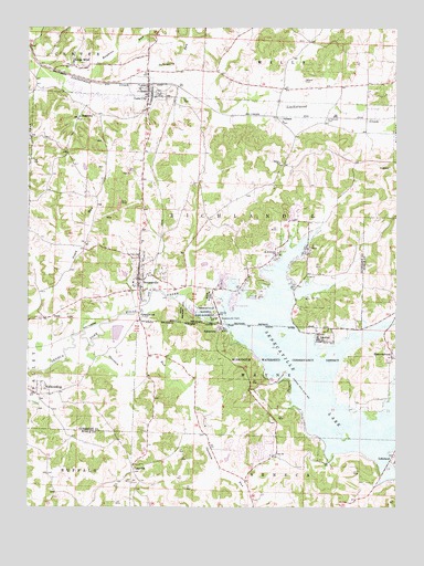
Senecaville, OH USGS Topographic Map
Click on map above to begin viewing in our Map Viewer.

This topographic map contains these locations and features:
Feature Name Type Latitude Longitude GNIS ID View Map
Beech Point School (historical)SchoolN39.9081°W81.4818°1054690View Map
Bennet School (historical)SchoolN39.9353°W81.3960°1054686View Map
BlacktopPopulated PlaceN39.9765°W81.4826°1062649View Map
Camp Seneca LakeReservoirN39.9207°W81.4697°1077680View Map
Camp Seneca Lake DamDamN39.9217°W81.4715°1077679View Map
ChasevillePopulated PlaceN39.8862°W81.4640°1062694View Map
ChasevillePost Office (historical)Post OfficeN39.8862°W81.4637°2041252View Map
Chestnut Grove Cottage AreaPopulated PlaceN39.9351°W81.4201°1960595View Map
Chumney FarmsLocaleN39.9850°W81.4322°2704748View Map
Coen ChurchChurchN39.8887°W81.4148°1039219View Map
Coens CemeteryCemeteryN39.8884°W81.4154°1963671View Map
Concord School (historical)SchoolN39.9362°W81.4248°1054688View Map
Depue RunStreamN39.9223°W81.3784°1039679View Map
Duch AdditionPopulated PlaceN39.9417°W81.4154°1960596View Map
East Shore Cottage AreaPopulated PlaceN39.9390°W81.4098°1960597View Map
Echo PointPopulated PlaceN39.9417°W81.4054°1960598View Map
Fairview School (historical)SchoolN39.9687°W81.3985°1054685View Map
Frame Number One CemeteryCemeteryN39.9966°W81.4065°1963722View Map
GibsonPopulated PlaceN39.9765°W81.4132°1064720View Map
Gibson Post Office (historical)Post OfficeN39.9765°W81.4137°1988928View Map
Gibson Station CemeteryCemeteryN39.9756°W81.4134°1963724View Map
GreenwoodPopulated PlaceN39.9248°W81.4618°1048804View Map
Hawkins RunStreamN39.9867°W81.4821°1041409View Map
Hickory Grove Cottage AreaPopulated PlaceN39.9423°W81.4135°1960599View Map
Infirmary RunStreamN39.9853°W81.4621°1041980View Map
KennonsburgPopulated PlaceN39.9151°W81.3757°1056372View Map
Kennonsburg Boat ClubLocaleN39.9026°W81.3776°1960630View Map
Kennonsburg CemeteryCemeteryN39.9131°W81.3768°1963683View Map
Kennonsburg Post Office (historical)Post OfficeN39.9153°W81.3762°2041178View Map
Kings MinePopulated PlaceN39.9901°W81.4846°1079581View Map
LakeviewPopulated PlaceN39.9220°W81.4332°1048902View Map
Land-O-Lakes Boating ClubLocaleN39.9215°W81.4329°1960631View Map
LashleyPopulated PlaceN39.9187°W81.4004°1048907View Map
Liberty School (historical)SchoolN39.9617°W81.4415°1054687View Map
Lore CityPopulated PlaceN39.9848°W81.4585°1057817View Map
Lore City CemeteryCemeteryN39.9797°W81.4527°1963729View Map
Lore City Fire DepartmentBuildingN39.9818°W81.4592°2549431View Map
Lore City Post OfficePost OfficeN39.9848°W81.4582°1988912View Map
Marina Point CampgroundLocaleN39.9292°W81.4304°1960600View Map
Miley School (historical)SchoolN39.9006°W81.4151°1050926View Map
Mud RunPopulated PlaceN39.8815°W81.3771°1960632View Map
New GottingenPopulated PlaceN39.9684°W81.3987°1054684View Map
Noble Cottage AreaPopulated PlaceN39.8881°W81.3846°1960633View Map
Opossum RunStreamN39.9170°W81.4796°1057902View Map
Pleasant Valley School (historical)SchoolN39.9965°W81.4037°1054683View Map
Robins Ridge Golf Club Dam Number OneDamN39.9384°W81.4415°1084295View Map
Robins Ridge Golf Club Dam Number TwoDamN39.9417°W81.4382°1079119View Map
Robins Ridge Golf Club Lake Number OneReservoirN39.9384°W81.4402°1079118View Map
Robins Ridge Golf Club Lake Number TwoReservoirN39.9417°W81.4382°1079120View Map
Rose AdditionPopulated PlaceN39.9215°W81.4337°1960634View Map
Saint Andrews ChurchChurchN39.9409°W81.4148°1045369View Map
Saint Patricks CemeteryCemeteryN39.9764°W81.3986°1045729View Map
Salem Baptist CemeteryCemeteryN39.9646°W81.4140°1963742View Map
Salem Baptist ChurchChurchN39.9648°W81.4137°1045888View Map
Secrest Elementary SchoolSchoolN39.9337°W81.4643°1054689View Map
Seneca Lake EstatesPopulated PlaceN39.9228°W81.3882°1960601View Map
Seneca Lake MarinaLocaleN39.9309°W81.4279°1960602View Map
Seneca Lake ResortLocaleN39.9520°W81.4110°1960603View Map
SenecavillePopulated PlaceN39.9342°W81.4623°1049165View Map
Senecaville CemeteryCemeteryN39.9395°W81.4632°1963744View Map
Senecaville DamDamN39.9259°W81.4355°1070937View Map
Senecaville Fire DepartmentBuildingN39.9347°W81.4636°2549429View Map
Senecaville LakeReservoirN39.8950°W81.3871°1058011View Map
Senecaville National Fish HatcheryLocaleN39.9256°W81.4376°1080187View Map
Senecaville Post OfficePost OfficeN39.9348°W81.4623°1988920View Map
Township of RichlandCivilN39.9485°W81.4430°1086189View Map
Township of WayneCivilN39.9168°W81.3820°1086753View Map
Village of Lore CityCivilN39.9832°W81.4601°2398476View Map
Village of SenecavilleCivilN39.9348°W81.4595°2399786View Map
WalhondingPopulated PlaceN39.9045°W81.4973°1065447View Map
Weaver CemeteryCemeteryN39.9862°W81.4060°1047639View Map
West Shore Cottage AreaPopulated PlaceN39.9384°W81.4187°1960604View Map

Note: Coordinates in the location and feature list above are referenced to NAD83 datum.


Copyright (C) 2008-2025 Ryan Niemi / Sunset Dynamics ... All Rights Reserved