TopoQuest Logo
Do you find TopoQuest useful?
Help keep TopoQuest running and adding new maps/features by donating!
Bitcoin:  19c7KJd3qBynnjoSw5npx9KScwjBe4ifkT
Litecoin:  LXs6TkuXGGXo1vDsWCkWVdjQX94eUKd6ui
Home View Maps Find Maps Find Places Resources & Links


Cambridge, Maine Topographic Map

USGS Map Title: Cambridge, ME
USGS Map MRC: 45069A4
DRG (GeoTIFF) Download: o45069a4.tif


Neighboring USGS Topographic Map Quads:


  Whetstone Pond, ME  
45069B5
 

  Guilford, ME  
45069B4
 

  Sangerville, ME  
45069B3
 

  Wellington, ME  
45069A5
 

  Cambridge, ME  
45069A4
 

  Dexter, ME  
45069A3
 

  Harmony, ME  
44069H5
 

  Hartland, ME  
44069H4
 

  Corinna, ME  
44069H3


Map MRC Location:

N46°
W70°
N46°
W69°
H8 H7 H6 H5 H4 H3 H2 H1
G8 G7 G6 G5 G4 G3 G2 G1
F8 F7 F6 F5 F4 F3 F2 F1
E8 E7 E6 E5 E4 E3 E2 E1
D8 D7 D6 D5 D4 D3 D2 D1
C8 C7 C6 C5 C4 C3 C2 C1
B8 B7 B6 B5 B4 B3 B2 B1
A8 A7 A6 A5 A4 A3 A2 A1
N45°
W70°
N45°
W69°

Cambridge, ME USGS 1:24K Topographic Map Preview:
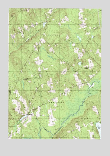
Cambridge, ME USGS Topographic Map
Click on map above to begin viewing in our Map Viewer.

This topographic map contains these locations and features:
Feature Name Type Latitude Longitude GNIS ID View Map
Austin BrookStreamN45.0548°W69.3848°561359View Map
CambridgePopulated PlaceN45.0242°W69.4739°563371View Map
Cambridge Elementary SchoolSchoolN45.0228°W69.4534°1908499View Map
Cambridge Fire DepartmentBuildingN45.0233°W69.4740°2552872View Map
Cambridge Flats SchoolSchoolN45.0223°W69.4425°563372View Map
Cambridge PondReservoirN45.0205°W69.4791°563373View Map
Cambridge Pond DamDamN45.0237°W69.4738°1774195View Map
Cambridge Post OfficePost OfficeN45.0230°W69.4730°1908500View Map
Dorr HillSummitN45.1046°W69.4939°565216View Map
Dorr Hill SchoolSchoolN45.1001°W69.4900°565217View Map
Ferguson BrookStreamN45.0170°W69.4834°566099View Map
Ferguson StreamStreamN45.0098°W69.4556°566103View Map
Fush HillSummitN45.0292°W69.3832°1908551View Map
Gilbert CemeteryCemeteryN45.0716°W69.4127°2736956View Map
Gilbert PondLakeN45.0724°W69.4041°566781View Map
Greenfield Hill AirportAirportN45.0357°W69.4796°582125View Map
Ham HillSummitN45.0373°W69.4951°567523View Map
Head of Pond SchoolSchoolN45.0153°W69.3875°567845View Map
Ike BrookStreamN45.0259°W69.4667°568552View Map
Jimmy BrookStreamN45.0109°W69.4503°568843View Map
Main Stream Sebasticook RiverStreamN45.0014°W69.4773°570671View Map
Manter SchoolSchoolN45.0970°W69.4528°570717View Map
Memorial Garden CemeteryCemeteryN45.0228°W69.4622°1908618View Map
Mount Pleasant CemeteryCemeteryN45.0275°W69.4662°571780View Map
Mud PondLakeN45.0980°W69.3871°571909View Map
Packard BrookStreamN45.0509°W69.3884°572906View Map
Page BrookStreamN45.0045°W69.4395°572916View Map
Pingree CemeteryCemeteryN45.1170°W69.4475°1910154View Map
Pingree CenterPopulated PlaceN45.1123°W69.4478°579622View Map
Pingree DamDamN45.1116°W69.4487°1773821View Map
Pingree PondReservoirN45.1097°W69.4519°1773822View Map
Ripley PondReservoirN45.0052°W69.3763°574227View Map
Smart SchoolSchoolN45.0826°W69.4012°575579View Map
Southworth SchoolSchoolN45.1059°W69.3981°575961View Map
Town of CambridgeCivilN45.0382°W69.4429°582383View Map
Town of ParkmanCivilN45.1090°W69.4410°579055View Map
Town of RipleyCivilN45.0073°W69.3964°582696View Map
Tyler CemeteryCemeteryN45.0877°W69.4627°2736965View Map
Webber SchoolSchoolN45.0528°W69.4023°577939View Map

Note: Coordinates in the location and feature list above are referenced to NAD83 datum.


Copyright (C) 2008-2025 Ryan Niemi / Sunset Dynamics ... All Rights Reserved