TopoQuest Logo
Do you find TopoQuest useful?
Help keep TopoQuest running and adding new maps/features by donating!
Bitcoin:  19c7KJd3qBynnjoSw5npx9KScwjBe4ifkT
Litecoin:  LXs6TkuXGGXo1vDsWCkWVdjQX94eUKd6ui
Home View Maps Find Maps Find Places Resources & Links


Allegre, Kentucky Topographic Map

USGS Map Title: Allegre, KY
USGS Map MRC: 36087H2
DRG (GeoTIFF) Download: o36087h2.tif


Neighboring USGS Topographic Map Quads:


  Haleys Mill, KY  
37087A3
 

  Kirkmansville, KY  
37087A2
 

  Rosewood, KY  
37087A1
 

  Honey Grove, KY  
36087H3
 

  Allegre, KY  
36087H2
 

  Sharon Grove, KY  
36087H1
 

  Pembroke, KY  
36087G3
 

  Elkton, KY  
36087G2
 

  Olmstead, KY  
36087G1


Map MRC Location:

N37°
W88°
N37°
W87°
H8 H7 H6 H5 H4 H3 H2 H1
G8 G7 G6 G5 G4 G3 G2 G1
F8 F7 F6 F5 F4 F3 F2 F1
E8 E7 E6 E5 E4 E3 E2 E1
D8 D7 D6 D5 D4 D3 D2 D1
C8 C7 C6 C5 C4 C3 C2 C1
B8 B7 B6 B5 B4 B3 B2 B1
A8 A7 A6 A5 A4 A3 A2 A1
N36°
W88°
N36°
W87°

Allegre, KY USGS 1:24K Topographic Map Preview:
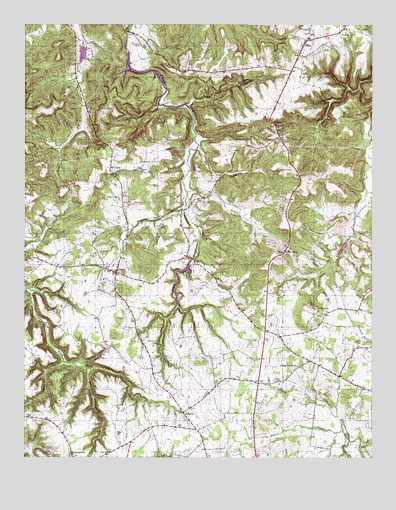
Allegre, KY USGS Topographic Map
Click on map above to begin viewing in our Map Viewer.

This topographic map contains these locations and features:
Feature Name Type Latitude Longitude GNIS ID View Map
AllegrePopulated PlaceN36.9287°W87.2172°485843View Map
Allegre Volunteer Fire DepartmentBuildingN36.9255°W87.2166°2636960View Map
Cedar GrovePopulated PlaceN36.9342°W87.1561°489193View Map
CliftyPopulated PlaceN36.9953°W87.1478°489678View Map
Clifty Volunteer Fire DepartmentBuildingN36.9961°W87.1459°2636962View Map
Collier SpringSpringN36.9006°W87.1527°2743141View Map
Collier Spring General Baptist ChurchChurchN36.9014°W87.1522°489848View Map
Dead Man HollowValleyN36.9003°W87.2272°490721View Map
Edwards CemeteryCemeteryN36.9945°W87.2080°491578View Map
Francis BranchStreamN36.8825°W87.1356°492433View Map
Francis CemeteryCemeteryN36.9581°W87.2081°492436View Map
Happy HollowValleyN36.9023°W87.2367°493704View Map
Kate BranchStreamN36.9653°W87.1864°495572View Map
Kirkman CemeteryCemeteryN36.9084°W87.2058°495799View Map
Kirkman CemeteryCemeteryN36.9503°W87.2161°495800View Map
Kirkmansville DivisionCivilN36.9660°W87.1665°1937090View Map
LibertyPopulated PlaceN36.8881°W87.1928°496351View Map
Mount TaborPopulated PlaceN36.9587°W87.2192°508649View Map
NarrowsGapN36.9717°W87.1606°499177View Map
Porter CemeteryCemeteryN36.8973°W87.1594°501143View Map
Powell LakeReservoirN36.9913°W87.2294°2743147View Map
Shelton BranchStreamN36.9475°W87.1914°503332View Map
Simons CemeteryCemeteryN36.9584°W87.1539°503528View Map
Slaughter CemeteryCemeteryN36.9973°W87.1364°503666View Map
Slim Jimmy BranchStreamN36.9762°W87.1903°503693View Map
Sulfur LickStreamN36.9817°W87.1289°504716View Map
Tabernacle ChurchChurchN36.8761°W87.2331°504899View Map
Tutt CemeteryCemeteryN36.8767°W87.2192°505690View Map
Wolf BranchStreamN36.9520°W87.1908°506981View Map

Note: Coordinates in the location and feature list above are referenced to NAD83 datum.


Copyright (C) 2008-2025 Ryan Niemi / Sunset Dynamics ... All Rights Reserved