TopoQuest Logo
Do you find TopoQuest useful?
Help keep TopoQuest running and adding new maps/features by donating!
Bitcoin:  19c7KJd3qBynnjoSw5npx9KScwjBe4ifkT
Litecoin:  LXs6TkuXGGXo1vDsWCkWVdjQX94eUKd6ui
Home View Maps Find Maps Find Places Resources & Links


Rosewood, Kentucky Topographic Map

USGS Map Title: Rosewood, KY
USGS Map MRC: 37087A1
DRG (GeoTIFF) Download: o37087a1.tif


Neighboring USGS Topographic Map Quads:


  Greenville, KY  
37087B2
 

  Drakesboro, KY  
37087B1
 

  Rochester, KY  
37086B8
 

  Kirkmansville, KY  
37087A2
 

  Rosewood, KY  
37087A1
 

  Dunmor, KY  
37086A8
 

  Allegre, KY  
36087H2
 

  Sharon Grove, KY  
36087H1
 

  Lewisburg, KY  
36086H8


Map MRC Location:

N38°
W88°
N38°
W87°
H8 H7 H6 H5 H4 H3 H2 H1
G8 G7 G6 G5 G4 G3 G2 G1
F8 F7 F6 F5 F4 F3 F2 F1
E8 E7 E6 E5 E4 E3 E2 E1
D8 D7 D6 D5 D4 D3 D2 D1
C8 C7 C6 C5 C4 C3 C2 C1
B8 B7 B6 B5 B4 B3 B2 B1
A8 A7 A6 A5 A4 A3 A2 A1
N37°
W88°
N37°
W87°

Rosewood, KY USGS 1:24K Topographic Map Preview:
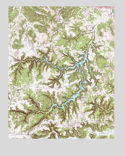
Rosewood, KY USGS Topographic Map
Click on map above to begin viewing in our Map Viewer.

This topographic map contains these locations and features:
Feature Name Type Latitude Longitude GNIS ID View Map
AgnesPopulated PlaceN37.0484°W87.0203°507379View Map
Buck CreekStreamN37.1184°W87.1103°488205View Map
Caring Wings Airport (historical)AirportN37.0442°W87.0628°517409View Map
Cliff Hill Baptist ChurchChurchN37.0127°W87.0851°489669View Map
Deer LickPopulated PlaceN37.0159°W87.0367°507835View Map
Diamond SpringsSpringN37.0239°W87.0067°490865View Map
JasonPopulated PlaceN37.0487°W87.0906°508331View Map
Lake MaloneReservoirN37.0312°W87.0606°497476View Map
Lake Malone State ParkParkN37.0762°W87.0478°495917View Map
Lazy BranchStreamN37.1128°W87.0128°496106View Map
Little Mountain (historical)Populated PlaceN37.1227°W87.0861°2743022View Map
Mays StorePopulated PlaceN37.0298°W87.1208°497752View Map
McPhearson CemeteryCemeteryN37.0548°W87.0580°497942View Map
Mount Vernon Church of ChristChurchN37.0475°W87.0690°498889View Map
Myers ChapelChurchN37.1070°W87.0286°499148View Map
Myers Chapel (historical)Populated PlaceN37.1068°W87.0276°2743026View Map
New Harmony Baptist ChurchChurchN37.0367°W87.1220°499324View Map
Norman BranchStreamN37.1159°W87.0156°499522View Map
Oak Grove CemeteryCemeteryN37.0392°W87.0347°499657View Map
Pryor CreekStreamN37.1023°W87.0239°501401View Map
Rocky Clifty CreekStreamN37.0814°W87.0331°502238View Map
RosewoodPopulated PlaceN37.0867°W87.0894°502355View Map
Sulphur Spring CreekStreamN37.0717°W87.0403°504761View Map
TyewhoppetyPopulated PlaceN37.0323°W87.1228°509254View Map
Union Worship ChurchChurchN37.0045°W87.1158°505825View Map
Whiskey BayBayN37.0533°W87.0339°2574384View Map
Whiskey BayPopulated PlaceN37.0521°W87.0336°2574385View Map
Whispering PinesPopulated PlaceN37.0402°W87.0426°2743107View Map
Whiterock CliffCliffN37.0514°W87.0389°506663View Map
Wiley ChapelChurchN37.0125°W87.0525°506757View Map

Note: Coordinates in the location and feature list above are referenced to NAD83 datum.


Copyright (C) 2008-2025 Ryan Niemi / Sunset Dynamics ... All Rights Reserved