TopoQuest Logo
Do you find TopoQuest useful?
Help keep TopoQuest running and adding new maps/features by donating!
Bitcoin:  19c7KJd3qBynnjoSw5npx9KScwjBe4ifkT
Litecoin:  LXs6TkuXGGXo1vDsWCkWVdjQX94eUKd6ui
Home View Maps Find Maps Find Places Resources & Links


Beaver Butte, Oregon Topographic Map

USGS Map Title: Beaver Butte, OR
USGS Map MRC: 45121A5
DRG (GeoTIFF) Download: o45121a5.tif


Neighboring USGS Topographic Map Quads:


  Wapinitia Pass, OR  
45121B6
 

  Post Point, OR  
45121B5
 

  Rock Creek Reservoir, OR  
45121B4
 

  Mount Wilson, OR  
45121A6
 

  Beaver Butte, OR  
45121A5
 

  Foreman Point, OR  
45121A4
 

  Fort Butte, OR  
44121H6
 

  Sidwalter Buttes, OR  
44121H5
 

  Hehe Butte, OR  
44121H4


Map MRC Location:

N46°
W122°
N46°
W121°
H8 H7 H6 H5 H4 H3 H2 H1
G8 G7 G6 G5 G4 G3 G2 G1
F8 F7 F6 F5 F4 F3 F2 F1
E8 E7 E6 E5 E4 E3 E2 E1
D8 D7 D6 D5 D4 D3 D2 D1
C8 C7 C6 C5 C4 C3 C2 C1
B8 B7 B6 B5 B4 B3 B2 B1
A8 A7 A6 A5 A4 A3 A2 A1
N45°
W122°
N45°
W121°

Beaver Butte, OR USGS 1:24K Topographic Map Preview:
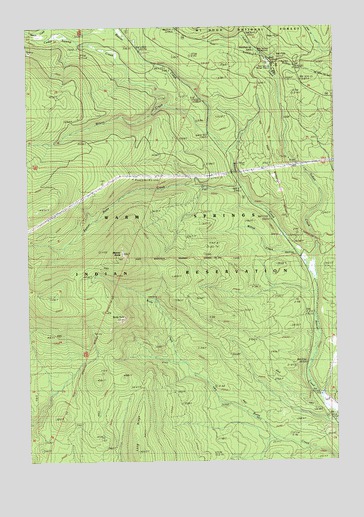
Beaver Butte, OR USGS Topographic Map
Click on map above to begin viewing in our Map Viewer.

This topographic map contains these locations and features:
Feature Name Type Latitude Longitude GNIS ID View Map
Bear SpringSpringN45.1154°W121.5262°1116560View Map
Bear Springs Ranger Station (historical)LocaleN45.1137°W121.5251°1137752View Map
Bear Springs Recreation SiteLocaleN45.1165°W121.5303°1161810View Map
Beaver ButteSummitN45.0598°W121.5881°1137798View Map
Beaver Butte CreekStreamN45.0771°W121.5370°1137799View Map
Beaver Creek DrivewayTrailN45.0932°W121.5384°1137826View Map
Cedar Swamp CreekStreamN45.1029°W121.5695°1139538View Map
Cold Spring CreekStreamN45.0887°W121.5428°1153159View Map
Cold Springs CreekStreamN45.0887°W121.5440°1134615View Map
Dahl PineLocaleN45.0143°W121.5003°1140591View Map
Indian CreekStreamN45.0534°W121.5095°1144029View Map
Long RidgeRidgeN45.0029°W121.5823°1145446View Map
McQuinn Strip (historical)AreaN45.0832°W121.5015°1116501View Map
Persia M Robinson Natural AreaAreaN45.0637°W121.5317°1161785View Map
Robinson Picnic AreaLocaleN45.0623°W121.5178°1167206View Map
Rocky PointSummitN45.0413°W121.5869°1148670View Map
Willow CreekStreamN45.0601°W121.5165°1152410View Map
Wilson CreekStreamN45.0937°W121.5526°1152458View Map

Note: Coordinates in the location and feature list above are referenced to NAD83 datum.


Copyright (C) 2008-2025 Ryan Niemi / Sunset Dynamics ... All Rights Reserved