TopoQuest Logo
Do you find TopoQuest useful?
Help keep TopoQuest running and adding new maps/features by donating!
Bitcoin:  19c7KJd3qBynnjoSw5npx9KScwjBe4ifkT
Litecoin:  LXs6TkuXGGXo1vDsWCkWVdjQX94eUKd6ui
Home View Maps Find Maps Find Places Resources & Links


Big Falls, Wisconsin Topographic Map

USGS Map Title: Big Falls, WI
USGS Map MRC: 44089E1
DRG (GeoTIFF) Download: o44089e1.tif


Neighboring USGS Topographic Map Quads:


  Tigerton NW, WI  
44089F2
 

  Tigerton, WI  
44089F1
 

  Marion, WI  
44088F8
 

  Iola, WI  
44089E2
 

  Big Falls, WI  
44089E1
 

  Symco, WI  
44088E8
 

  Scandinavia, WI  
44089D2
 

  Ogdensburg, WI  
44089D1
 

  Manawa, WI  
44088D8


Map MRC Location:

N45°
W90°
N45°
W89°
H8 H7 H6 H5 H4 H3 H2 H1
G8 G7 G6 G5 G4 G3 G2 G1
F8 F7 F6 F5 F4 F3 F2 F1
E8 E7 E6 E5 E4 E3 E2 E1
D8 D7 D6 D5 D4 D3 D2 D1
C8 C7 C6 C5 C4 C3 C2 C1
B8 B7 B6 B5 B4 B3 B2 B1
A8 A7 A6 A5 A4 A3 A2 A1
N44°
W90°
N44°
W89°

Big Falls, WI USGS 1:24K Topographic Map Preview:
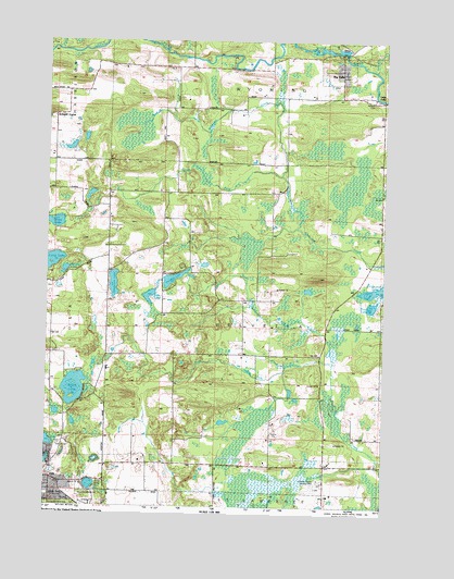
Big Falls, WI USGS Topographic Map
Click on map above to begin viewing in our Map Viewer.

This topographic map contains these locations and features:
Feature Name Type Latitude Longitude GNIS ID View Map
Big FallsPopulated PlaceN44.6155°W89.0162°1561719View Map
Big Falls 1907437 DamDamN44.6200°W89.0151°1791718View Map
Big Falls CemeteryCemeteryN44.6116°W89.0173°1850410View Map
Big Falls Dairy FarmLocaleN44.6103°W89.0198°1850411View Map
Big Falls Pond 160ReservoirN44.6206°W89.0201°1791719View Map
Blake School (historical)SchoolN44.5400°W89.0518°1850412View Map
Campbell LakeLakeN44.5571°W89.0039°1562684View Map
Central County AirportAirportN44.5052°W89.0237°1582019View Map
Comet CreekStreamN44.6211°W89.1207°1563293View Map
Dou School (historical)SchoolN44.5105°W89.0215°1850433View Map
Goodhal LakeLakeN44.5602°W89.0782°1565626View Map
Grass LakeLakeN44.5750°W89.1224°1565771View Map
Gregerson LakeLakeN44.5588°W89.1003°1565891View Map
Hatch LakeLakeN44.5311°W89.1147°1566126View Map
Hitterdahl ChurchChurchN44.5586°W89.1248°1566488View Map
Iola - Scandinavia Elementary SchoolSchoolN44.5037°W89.1246°1850476View Map
Iola CemeteryCemeteryN44.5002°W89.1237°1850475View Map
Iola-Scandinavia High SchoolSchoolN44.5036°W89.1246°1850477View Map
Kating LakeLakeN44.5056°W89.1084°1567361View Map
Keller Whitcomb Creek Woods State Natural AreaParkN44.5880°W89.0673°2061661View Map
Little FallsFallsN44.6075°W89.0015°1568258View Map
Lola CemeteryCemeteryN44.5002°W89.1236°1568501View Map
Long LakeLakeN44.5644°W89.1235°1568572View Map
Lutz LakeLakeN44.5556°W89.0870°1568823View Map
North Fork Blake CreekStreamN44.5378°W89.0187°1570429View Map
Price LakeLakeN44.5530°W89.0045°1571931View Map
Round LakeLakeN44.5623°W89.1183°1572671View Map
Schmidt CornerPopulated PlaceN44.6030°W89.1226°1577815View Map
Selmer School (historical)SchoolN44.5916°W89.1223°1850566View Map
South Fork Blake CreekStreamN44.5378°W89.0184°1574440View Map
South Fork Whitcomb CreekStreamN44.5880°W89.0373°1574455View Map
Spaulding CreekStreamN44.6158°W89.0029°1574519View Map
Stony Ridge School (historical)SchoolN44.5475°W89.0004°1850577View Map
Thoe School (historical)SchoolN44.5628°W89.1021°1850582View Map
Town of HelvetiaCivilN44.5472°W89.0417°1583376View Map
Village of Big FallsCivilN44.6174°W89.0166°1582808View Map
Village of IolaCivilN44.5091°W89.1249°1583431View Map
Wyoming Guernsey Stock FarmLocaleN44.6097°W89.0271°1850606View Map

Note: Coordinates in the location and feature list above are referenced to NAD83 datum.


Copyright (C) 2008-2024 Ryan Niemi / Sunset Dynamics ... All Rights Reserved