TopoQuest Logo
Do you find TopoQuest useful?
Help keep TopoQuest running and adding new maps/features by donating!
Bitcoin:  19c7KJd3qBynnjoSw5npx9KScwjBe4ifkT
Litecoin:  LXs6TkuXGGXo1vDsWCkWVdjQX94eUKd6ui
Home View Maps Find Maps Find Places Resources & Links


Camp Wood, Texas Topographic Map

USGS Map Title: Camp Wood, TX
USGS Map MRC: 29100F1
DRG (GeoTIFF) Download: o29100f1.tif


Neighboring USGS Topographic Map Quads:


  Half Moon Prairie, TX  
29100G2
 

  Vance, TX  
29100G1
 

  Jo Jan Van Camp, TX  
29099G8
 

  Kelley Peak, TX  
29100F2
 

  Camp Wood, TX  
29100F1
 

  Crown Mountain, TX  
29099F8
 

  Bull Waterhole, TX  
29100E2
 

  Montell, TX  
29100E1
 

  Lake Creek, TX  
29099E8


Map MRC Location:

N30°
W101°
N30°
W100°
H8 H7 H6 H5 H4 H3 H2 H1
G8 G7 G6 G5 G4 G3 G2 G1
F8 F7 F6 F5 F4 F3 F2 F1
E8 E7 E6 E5 E4 E3 E2 E1
D8 D7 D6 D5 D4 D3 D2 D1
C8 C7 C6 C5 C4 C3 C2 C1
B8 B7 B6 B5 B4 B3 B2 B1
A8 A7 A6 A5 A4 A3 A2 A1
N29°
W101°
N29°
W100°

Camp Wood, TX USGS 1:24K Topographic Map Preview:
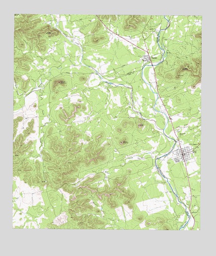
Camp Wood, TX USGS Topographic Map
Click on map above to begin viewing in our Map Viewer.

This topographic map contains these locations and features:
Feature Name Type Latitude Longitude GNIS ID View Map
BarksdalePopulated PlaceN29.7252°W100.0340°1330049View Map
Barksdale Post OfficePost OfficeN29.7270°W100.0360°2732347View Map
Bruce ParkParkN29.6830°W100.0165°1331390View Map
Camp FawcettLocaleN29.7422°W100.0317°1331975View Map
Camp WoodPopulated PlaceN29.6694°W100.0123°1332024View Map
Camp Wood City OfficesBuildingN29.6694°W100.0134°2753710View Map
Camp Wood CreekStreamN29.6794°W100.0220°1332025View Map
Camp Wood Post OfficePost OfficeN29.6721°W100.0131°2731558View Map
Camp Wood SpringSpringN29.6919°W100.0253°1998402View Map
City of Camp WoodCivilN29.6690°W100.0109°2409970View Map
Dry CreekStreamN29.7461°W100.0215°1373461View Map
Dutch CreekStreamN29.7097°W100.1059°1334810View Map
Emergency Medical Services Camp WoodBuildingN29.6703°W100.0142°2655946View Map
Garden of MemoriesCemeteryN29.6739°W100.0038°1336383View Map
Meridian MountainSummitN29.7188°W100.0131°1341380View Map
Military MountainSummitN29.7105°W100.0937°1341605View Map
Miller CreekStreamN29.6663°W100.0301°1341649View Map
North Spring CreekStreamN29.7036°W100.1179°1342811View Map
Nueces Can High SchoolSchoolN29.7244°W100.0362°1342912View Map
Nueces Canyon Volunteer Fire DepartmentBuildingN29.6695°W100.0134°2551195View Map
Old Faithful SpringSpringN29.6799°W100.0142°1343142View Map
Pikes PeakSummitN29.6860°W100.0409°1343995View Map
Powers MountainSummitN29.7394°W100.0998°1344472View Map
Pulliam CreekStreamN29.6836°W100.0251°1375580View Map
Ranch CreekStreamN29.6324°W100.0070°1344749View Map
Spring CreekStreamN29.7202°W100.0762°1347714View Map
Wildcat MountainSummitN29.6758°W100.0520°1350066View Map

Note: Coordinates in the location and feature list above are referenced to NAD83 datum.


Copyright (C) 2008-2024 Ryan Niemi / Sunset Dynamics ... All Rights Reserved