TopoQuest Logo
Do you find TopoQuest useful?
Help keep TopoQuest running and adding new maps/features by donating!
Bitcoin:  19c7KJd3qBynnjoSw5npx9KScwjBe4ifkT
Litecoin:  LXs6TkuXGGXo1vDsWCkWVdjQX94eUKd6ui
Home View Maps Find Maps Find Places Resources & Links


Bronwood, Georgia Topographic Map

USGS Map Title: Bronwood, GA
USGS Map MRC: 31084G3
DRG (GeoTIFF) Download: o31084g3.tif


Neighboring USGS Topographic Map Quads:


  Bottsford, GA  
31084H4
 

  Smithville West, GA  
31084H3
 

  Smithville East, GA  
31084H2
 

  Dawson, GA  
31084G4
 

  Bronwood, GA  
31084G3
 

  Neyami, GA  
31084G2
 

  Chickasawhatchee, GA  
31084F4
 

  Sasser, GA  
31084F3
 

  Leesburg, GA  
31084F2


Map MRC Location:

N32°
W85°
N32°
W84°
H8 H7 H6 H5 H4 H3 H2 H1
G8 G7 G6 G5 G4 G3 G2 G1
F8 F7 F6 F5 F4 F3 F2 F1
E8 E7 E6 E5 E4 E3 E2 E1
D8 D7 D6 D5 D4 D3 D2 D1
C8 C7 C6 C5 C4 C3 C2 C1
B8 B7 B6 B5 B4 B3 B2 B1
A8 A7 A6 A5 A4 A3 A2 A1
N31°
W85°
N31°
W84°

Bronwood, GA USGS 1:24K Topographic Map Preview:
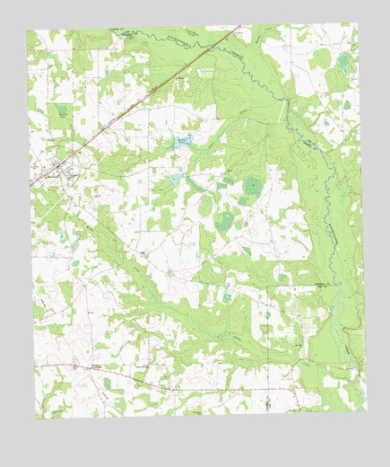
Bronwood, GA USGS Topographic Map
Click on map above to begin viewing in our Map Viewer.

This topographic map contains these locations and features:
Feature Name Type Latitude Longitude GNIS ID View Map
Bethel CemeteryCemeteryN31.7668°W84.3613°311146View Map
Bethel ChurchChurchN31.8279°W84.3594°354593View Map
Bethel Church (historical)ChurchN31.7671°W84.3613°344623View Map
Bridges CrossroadPopulated PlaceN31.7660°W84.3538°311789View Map
BronwoodPopulated PlaceN31.8310°W84.3644°354864View Map
Bronwood DivisionCivilN31.8183°W84.3411°1936135View Map
Bronwood Fire DepartmentBuildingN31.8301°W84.3638°2604208View Map
Bronwood Post OfficePost OfficeN31.8316°W84.3638°1705313View Map
Bronwood School (historical)SchoolN31.8307°W84.3696°344627View Map
Chokeelagee CreekStreamN31.8702°W84.3099°355152View Map
Curry Hill ChurchChurchN31.7718°W84.2732°313221View Map
Greater Macedonia CemeteryCemeteryN31.7666°W84.3324°344655View Map
Greater Macedonia ChurchChurchN31.7671°W84.3319°314809View Map
Gunnels Academy (historical)SchoolN31.8549°W84.3532°344657View Map
Hill CemeteryCemeteryN31.7916°W84.3019°315411View Map
Hilokee CreekStreamN31.8671°W84.2874°356312View Map
Hollis BridgeBridgeN31.7646°W84.2532°343385View Map
Holly Mott School (historical)SchoolN31.8274°W84.3305°344660View Map
Macedonia CemeteryCemeteryN31.7504°W84.3119°317519View Map
McGill PondReservoirN31.8380°W84.3176°317916View Map
McGill Pond DamDamN31.8377°W84.3135°338500View Map
Middle CreekStreamN31.7593°W84.2541°318067View Map
New CemeteryCemeteryN31.8318°W84.3538°344677View Map
New Mount ChurchChurchN31.8585°W84.3191°319482View Map
Old Church CemeteryCemeteryN31.8321°W84.3727°319959View Map
Olivers MillPopulated PlaceN31.8724°W84.3363°332573View Map
Salem CemeteryCemeteryN31.8016°W84.3316°344694View Map
Salem ChurchChurchN31.8016°W84.3321°322350View Map
Sanders Gift ChurchChurchN31.7521°W84.3685°322444View Map
Shiloh CemeteryCemeteryN31.8277°W84.3013°344697View Map
Shiloh ChurchChurchN31.8282°W84.3007°322863View Map
Spear LakeReservoirN31.8085°W84.3637°338499View Map
Spear Lake DamDamN31.8102°W84.3632°338498View Map
Sugar CreekStreamN31.8510°W84.2807°323718View Map
Town of BronwoodCivilN31.8305°W84.3643°2405326View Map
Tucker CemeteryCemeteryN31.8188°W84.3582°344706View Map
Wolf Pit PondLakeN31.8499°W84.3621°325509View Map
Wrights Bridge (historical)BridgeN31.8432°W84.2769°344711View Map

Note: Coordinates in the location and feature list above are referenced to NAD83 datum.


Copyright (C) 2008-2025 Ryan Niemi / Sunset Dynamics ... All Rights Reserved