TopoQuest Logo
Do you find TopoQuest useful?
Help keep TopoQuest running and adding new maps/features by donating!
Bitcoin:  19c7KJd3qBynnjoSw5npx9KScwjBe4ifkT
Litecoin:  LXs6TkuXGGXo1vDsWCkWVdjQX94eUKd6ui
Home View Maps Find Maps Find Places Resources & Links


Bottsford, Georgia Topographic Map

USGS Map Title: Bottsford, GA
USGS Map MRC: 31084H4
DRG (GeoTIFF) Download: o31084h4.tif


Neighboring USGS Topographic Map Quads:


  Preston, GA  
32084A5
 

  Plains, GA  
32084A4
 

  Lake Collins, GA  
32084A3
 

  Parrott, GA  
31084H5
 

  Bottsford, GA  
31084H4
 

  Smithville West, GA  
31084H3
 

  Shellman, GA  
31084G5
 

  Dawson, GA  
31084G4
 

  Bronwood, GA  
31084G3


Map MRC Location:

N32°
W85°
N32°
W84°
H8 H7 H6 H5 H4 H3 H2 H1
G8 G7 G6 G5 G4 G3 G2 G1
F8 F7 F6 F5 F4 F3 F2 F1
E8 E7 E6 E5 E4 E3 E2 E1
D8 D7 D6 D5 D4 D3 D2 D1
C8 C7 C6 C5 C4 C3 C2 C1
B8 B7 B6 B5 B4 B3 B2 B1
A8 A7 A6 A5 A4 A3 A2 A1
N31°
W85°
N31°
W84°

Bottsford, GA USGS 1:24K Topographic Map Preview:
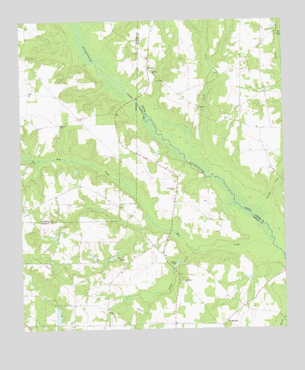
Bottsford, GA USGS Topographic Map
Click on map above to begin viewing in our Map Viewer.

This topographic map contains these locations and features:
Feature Name Type Latitude Longitude GNIS ID View Map
Bear CreekStreamN31.9082°W84.3807°354500View Map
Beulah Primitive Baptist ChurchChurchN31.8821°W84.4574°344624View Map
Beulah School (historical)SchoolN31.8818°W84.4571°344625View Map
BottsfordPopulated PlaceN31.9807°W84.4380°354817View Map
CottondalePopulated PlaceN31.9088°W84.4369°344638View Map
Enterprise CemeteryCemeteryN31.8940°W84.4235°344650View Map
Enterprise ChurchChurchN31.8941°W84.4232°355707View Map
Halls Bridge (historical)BridgeN31.9424°W84.4205°344658View Map
Mossydell School (historical)SchoolN31.9718°W84.4196°343468View Map
New Beulah CemeteryCemeteryN31.8818°W84.4563°344676View Map
New Hope CemeteryCemeteryN31.9035°W84.4546°344678View Map
New Hope ChurchChurchN31.9038°W84.4541°319383View Map
New Lebanon ChurchChurchN31.9638°W84.4135°319457View Map
Parker Mill (historical)LocaleN31.9163°W84.4430°344681View Map
Pessell CreekStreamN31.9243°W84.3846°320401View Map
Pleasant HillPopulated PlaceN31.8785°W84.4027°332710View Map
Pleasant Hill Presbyterian ChurchChurchN31.8763°W84.4052°344688View Map
Providence CemeteryCemeteryN31.9944°W84.3751°321179View Map
Providence Church (historical)ChurchN31.9949°W84.3755°343489View Map
Providence School (historical)SchoolN31.9949°W84.3755°343490View Map
Reedy CreekStreamN31.9063°W84.4177°321449View Map
Rural Hill ChurchChurchN31.9585°W84.4794°322004View Map
Saint Lukes ChurchChurchN31.9318°W84.4271°322160View Map
Saint Marks CemeteryCemeteryN31.9796°W84.4369°343496View Map
Saint Marks ChurchChurchN31.9791°W84.4357°322175View Map
Ty Ty CreekStreamN31.9466°W84.4146°356604View Map
Wallers Mill (historical)LocaleN31.9018°W84.4246°344708View Map
Wallers PondReservoirN31.9016°W84.4260°333354View Map
Wallers Pond DamDamN31.9016°W84.4260°338512View Map
Worner (historical)Populated PlaceN31.8938°W84.4585°344710View Map

Note: Coordinates in the location and feature list above are referenced to NAD83 datum.


Copyright (C) 2008-2025 Ryan Niemi / Sunset Dynamics ... All Rights Reserved