TopoQuest Logo
Do you find TopoQuest useful?
Help keep TopoQuest running and adding new maps/features by donating!
Bitcoin:  19c7KJd3qBynnjoSw5npx9KScwjBe4ifkT
Litecoin:  LXs6TkuXGGXo1vDsWCkWVdjQX94eUKd6ui
Home View Maps Find Maps Find Places Resources & Links


Smithville West, Georgia Topographic Map

USGS Map Title: Smithville West, GA
USGS Map MRC: 31084H3
DRG (GeoTIFF) Download: o31084h3.tif


Neighboring USGS Topographic Map Quads:


  Plains, GA  
32084A4
 

  Lake Collins, GA  
32084A3
 

  Americus, GA  
32084A2
 

  Bottsford, GA  
31084H4
 

  Smithville West, GA  
31084H3
 

  Smithville East, GA  
31084H2
 

  Dawson, GA  
31084G4
 

  Bronwood, GA  
31084G3
 

  Neyami, GA  
31084G2


Map MRC Location:

N32°
W85°
N32°
W84°
H8 H7 H6 H5 H4 H3 H2 H1
G8 G7 G6 G5 G4 G3 G2 G1
F8 F7 F6 F5 F4 F3 F2 F1
E8 E7 E6 E5 E4 E3 E2 E1
D8 D7 D6 D5 D4 D3 D2 D1
C8 C7 C6 C5 C4 C3 C2 C1
B8 B7 B6 B5 B4 B3 B2 B1
A8 A7 A6 A5 A4 A3 A2 A1
N31°
W85°
N31°
W84°

Smithville West, GA USGS 1:24K Topographic Map Preview:
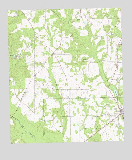
Smithville West, GA USGS Topographic Map
Click on map above to begin viewing in our Map Viewer.

This topographic map contains these locations and features:
Feature Name Type Latitude Longitude GNIS ID View Map
Andrews Mill (historical)LocaleN31.9768°W84.3038°343414View Map
Bethel ChurchChurchN31.9163°W84.2655°311167View Map
Bethlehem ChurchChurchN31.9566°W84.3663°311231View Map
Blackshire CemeteryCemeteryN31.9734°W84.2789°354760View Map
Cedar Springs ChurchChurchN31.9913°W84.3519°312499View Map
City of SmithvilleCivilN31.9013°W84.2552°2405478View Map
Croxton CrossroadsPopulated PlaceN31.9588°W84.3246°331490View Map
Cypress PondLakeN31.9163°W84.2996°313254View Map
Davison MillLocaleN31.9552°W84.3674°343433View Map
Edwards (historical)Populated PlaceN31.8760°W84.2932°343381View Map
Green Grove ChurchChurchN31.8982°W84.2646°314836View Map
Hebron CemeteryCemeteryN31.9583°W84.3274°343450View Map
Hebron ChurchChurchN31.9582°W84.3269°356246View Map
Jerusalem Grove ChurchChurchN31.8938°W84.2649°316100View Map
Koinonia Community LakeReservoirN31.9835°W84.2882°341334View Map
Koinonia Community Lake DamDamN31.9835°W84.2882°341333View Map
Lee County Fire Department Station 4 SmithvilleBuildingN31.9018°W84.2520°2603781View Map
Liberty CemeteryCemeteryN31.9465°W84.2568°343460View Map
Liberty ChurchChurchN31.9468°W84.2563°316807View Map
Little Muckaloochee CreekStreamN31.9841°W84.3071°356362View Map
McCree Lake NorthReservoirN31.8883°W84.2799°341029View Map
McCree Lake North DamDamN31.8852°W84.2816°341028View Map
McCree Lake SouthReservoirN31.8816°W84.2910°337662View Map
McCree Lake South DamDamN31.8785°W84.2882°337661View Map
Mitchell Grove ChurchChurchN31.9510°W84.2927°318345View Map
Mossy CreekStreamN31.8849°W84.3577°318535View Map
Mount Zion ChurchChurchN31.9904°W84.2816°318966View Map
New Hope ChurchChurchN31.8996°W84.2680°319382View Map
Rylander CemeteryCemeteryN31.9683°W84.3382°343493View Map
Rylander ChurchChurchN31.9682°W84.3377°322028View Map
Saint Pauls ChurchChurchN31.9329°W84.3460°322256View Map
SmithvillePopulated PlaceN31.9004°W84.2519°356540View Map
Smithville AcademySchoolN31.9041°W84.2585°323163View Map
Smithville Airport (historical)AirportN31.9041°W84.3116°343402View Map
Smithville Police DepartmentBuildingN31.9036°W84.2525°2733740View Map
Southwest Sumter Volunteer Fire DepartmentBuildingN31.9590°W84.3260°2604648View Map
SumterPopulated PlaceN31.9493°W84.2549°333160View Map
Thomas MillpondReservoirN31.9572°W84.3685°324087View Map
Thomas Millpond DamDamN31.9579°W84.3688°341335View Map
Thomson School (historical)SchoolN31.9574°W84.3249°343510View Map
Tropic School (historical)SchoolN31.9813°W84.3357°343512View Map
Wells Mill (historical)LocaleN31.9182°W84.2555°343514View Map
Wells MillpondReservoirN31.9207°W84.2581°324995View Map
Willburn BridgeBridgeN31.9004°W84.3724°344709View Map
Williams CemeteryCemeteryN31.9246°W84.2707°343517View Map
Zion Hope ChurchChurchN31.9646°W84.2524°325710View Map

Note: Coordinates in the location and feature list above are referenced to NAD83 datum.


Copyright (C) 2008-2024 Ryan Niemi / Sunset Dynamics ... All Rights Reserved