TopoQuest Logo
Do you find TopoQuest useful?
Help keep TopoQuest running and adding new maps/features by donating!
Bitcoin:  19c7KJd3qBynnjoSw5npx9KScwjBe4ifkT
Litecoin:  LXs6TkuXGGXo1vDsWCkWVdjQX94eUKd6ui
Home View Maps Find Maps Find Places Resources & Links


Canton, Mississippi Topographic Map

USGS Map Title: Canton, MS
USGS Map MRC: 32090E1
DRG (GeoTIFF) Download: o32090e1.tif


Neighboring USGS Topographic Map Quads:


  Berryville, MS  
32090F2
 

  Way, MS  
32090F1
 

  Sharon, MS  
32089F8
 

  Charlton, MS  
32090E2
 

  Canton, MS  
32090E1
 

  Shoccoe, MS  
32089E8
 

  Ridgeland, MS  
32090D2
 

  Madison, MS  
32090D1
 

  Goshen Springs, MS  
32089D8


Map MRC Location:

N33°
W91°
N33°
W90°
H8 H7 H6 H5 H4 H3 H2 H1
G8 G7 G6 G5 G4 G3 G2 G1
F8 F7 F6 F5 F4 F3 F2 F1
E8 E7 E6 E5 E4 E3 E2 E1
D8 D7 D6 D5 D4 D3 D2 D1
C8 C7 C6 C5 C4 C3 C2 C1
B8 B7 B6 B5 B4 B3 B2 B1
A8 A7 A6 A5 A4 A3 A2 A1
N32°
W91°
N32°
W90°

Canton, MS USGS 1:24K Topographic Map Preview:
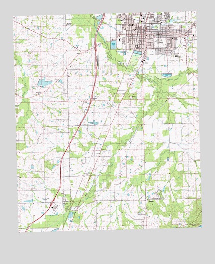
Canton, MS USGS Topographic Map
Click on map above to begin viewing in our Map Viewer.

This topographic map contains these locations and features:
Feature Name Type Latitude Longitude GNIS ID View Map
BallardPopulated PlaceN32.6029°W90.0787°666492View Map
Buckhorn CemeteryCemeteryN32.5766°W90.0463°2042945View Map
Buckhorn ChurchChurchN32.5763°W90.0462°667744View Map
C A Garbo Lake DamDamN32.5068°W90.0884°681450View Map
C M Wade Lake DamDamN32.5851°W90.0951°681519View Map
CantonPopulated PlaceN32.6126°W90.0368°691133View Map
Canton AcademySchoolN32.5993°W90.0145°1805814View Map
Canton CemeteryCemeteryN32.6079°W90.0281°1805815View Map
Canton Elementary SchoolSchoolN32.6096°W90.0168°1805816View Map
Canton Fire Department Station 1BuildingN32.6169°W90.0354°2667793View Map
Canton Fire Department Station 2BuildingN32.6136°W90.0165°2667703View Map
Canton Fire Department Station 3BuildingN32.6129°W90.0453°2667823View Map
Canton Fire Department Station 4BuildingN32.5938°W90.0799°2667736View Map
Canton High SchoolSchoolN32.6210°W90.0493°676820View Map
Canton Police DepartmentBuildingN32.6168°W90.0354°2754227View Map
Canton Post OfficePost OfficeN32.6118°W90.0372°2756656View Map
City of CantonCivilN32.5976°W90.0329°2403988View Map
DeerfieldPopulated PlaceN32.5193°W90.0284°1805817View Map
Fairview ChurchChurchN32.5118°W90.0376°1805818View Map
Fairview Church CemeteryCemeteryN32.5116°W90.0373°2042959View Map
GluckstadtPopulated PlaceN32.5165°W90.1009°691892View Map
Greater Ross ChapelChurchN32.5165°W90.0929°1805819View Map
Greater Ross Chapel CemeteryCemeteryN32.5164°W90.0932°2042970View Map
Harvey ChapelChurchN32.5613°W90.0770°1805820View Map
Harvey Chapel CemeteryCemeteryN32.5611°W90.0766°2042974View Map
Hermit Jones Lake DamDamN32.5168°W90.1151°681457View Map
Hot Water DitchCanalN32.6171°W90.0573°671514View Map
Interchange 112CrossingN32.5171°W90.1015°691436View Map
Interchange 119CrossingN32.6062°W90.0690°691437View Map
Little Bear CreekStreamN32.5785°W90.0284°672539View Map
M E Ragsdale Pond DamDamN32.5635°W90.0684°681507View Map
Madison County Sheriff's OfficeBuildingN32.5872°W90.0448°2754236View Map
Madison River Oaks Medical CenterHospitalN32.5816°W90.0833°2672745View Map
Maris TownPopulated PlaceN32.6237°W90.0190°686108View Map
McNeal Elementary SchoolSchoolN32.6176°W90.0437°711617View Map
MeltonvillePopulated PlaceN32.5165°W90.0379°692067View Map
Mount Able CemeteryCemeteryN32.6035°W90.0173°673907View Map
Mount Able ChurchChurchN32.6046°W90.0073°673908View Map
New Mount Zion CemeteryCemeteryN32.5167°W90.0725°674785View Map
New Mount Zion ChurchChurchN32.5171°W90.0593°674789View Map
Nichols Elementary SchoolSchoolN32.6060°W90.0412°1805821View Map
Old Madison ChurchChurchN32.6193°W90.0884°675203View Map
Old Madison Presbyterian CemeteryCemeteryN32.6201°W90.0889°2043012View Map
Old Madison SchoolSchoolN32.6190°W90.0887°1805822View Map
Patton LakeReservoirN32.5093°W90.0894°675505View Map
Pleasant Grove CemeteryCemeteryN32.5799°W90.1101°2043024View Map
Pleasant Grove ChurchChurchN32.5796°W90.1098°676014View Map
Priestley Chapel Missionary Baptist Church CemeteryCemeteryN32.6055°W90.0838°2043022View Map
Ragsdale LakeReservoirN32.5622°W90.0708°676453View Map
Red Bud ParkParkN32.6074°W90.0451°1805823View Map
Ross CemeteryCemeteryN32.5279°W90.0888°676889View Map
Saint Joseph Catholic Church CemeteryCemeteryN32.5192°W90.1067°2043044View Map
Saint Joseph ChurchChurchN32.5185°W90.1070°677099View Map
SloanPopulated PlaceN32.5601°W90.0598°677882View Map
South Madison County Fire Protection District Gluckstadt Volunteer Fire DepartmentBuildingN32.5122°W90.0845°2667754View Map
Walnut CreekStreamN32.5854°W90.0309°679298View Map
WDGM-FM (Canton)TowerN32.5010°W90.0412°680225View Map

Note: Coordinates in the location and feature list above are referenced to NAD83 datum.


Copyright (C) 2008-2024 Ryan Niemi / Sunset Dynamics ... All Rights Reserved