TopoQuest Logo
Do you find TopoQuest useful?
Help keep TopoQuest running and adding new maps/features by donating!
Bitcoin:  19c7KJd3qBynnjoSw5npx9KScwjBe4ifkT
Litecoin:  LXs6TkuXGGXo1vDsWCkWVdjQX94eUKd6ui
Home View Maps Find Maps Find Places Resources & Links


Berryville, Mississippi Topographic Map

USGS Map Title: Berryville, MS
USGS Map MRC: 32090F2
DRG (GeoTIFF) Download: o32090f2.tif


Neighboring USGS Topographic Map Quads:


  Benton, MS  
32090G3
 

  Linwood, MS  
32090G2
 

  Vaughan, MS  
32090G1
 

  Bentonia, MS  
32090F3
 

  Berryville, MS  
32090F2
 

  Way, MS  
32090F1
 

  Flora, MS  
32090E3
 

  Charlton, MS  
32090E2
 

  Canton, MS  
32090E1


Map MRC Location:

N33°
W91°
N33°
W90°
H8 H7 H6 H5 H4 H3 H2 H1
G8 G7 G6 G5 G4 G3 G2 G1
F8 F7 F6 F5 F4 F3 F2 F1
E8 E7 E6 E5 E4 E3 E2 E1
D8 D7 D6 D5 D4 D3 D2 D1
C8 C7 C6 C5 C4 C3 C2 C1
B8 B7 B6 B5 B4 B3 B2 B1
A8 A7 A6 A5 A4 A3 A2 A1
N32°
W91°
N32°
W90°

Berryville, MS USGS 1:24K Topographic Map Preview:
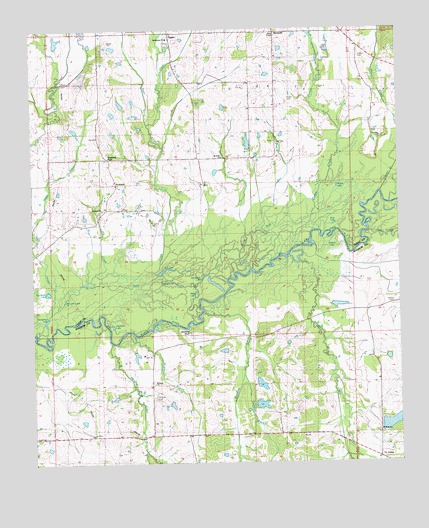
Berryville, MS USGS Topographic Map
Click on map above to begin viewing in our Map Viewer.

This topographic map contains these locations and features:
Feature Name Type Latitude Longitude GNIS ID View Map
Bear CreekStreamN32.6918°W90.1348°666641View Map
Beaties Bluff Post Office (historical)Post OfficeN32.6579°W90.2084°712162View Map
Beatties BluffCliffN32.6637°W90.1976°666681View Map
Beatties BranchStreamN32.6626°W90.2173°666682View Map
Bell BranchStreamN32.6985°W90.1637°666769View Map
BerryvillePopulated PlaceN32.7487°W90.1662°690982View Map
Bethlehem ChurchChurchN32.7474°W90.2031°691076View Map
Big Black LakeLakeN32.6737°W90.2456°667075View Map
Big LakeLakeN32.6770°W90.2323°667124View Map
Burg CreekStreamN32.7407°W90.1509°691132View Map
C G Thomas Lake DamDamN32.7185°W90.1751°681601View Map
Cameron BranchStreamN32.6507°W90.1787°667959View Map
Cameron CemeteryCemeteryN32.6271°W90.1646°2042947View Map
Campbell ChapelChurchN32.6332°W90.1595°667997View Map
Cat LakeLakeN32.6807°W90.2051°668151View Map
Deadman LakeLakeN32.6647°W90.2227°669171View Map
Deer CreekStreamN32.6785°W90.2298°669199View Map
FugatePopulated PlaceN32.7490°W90.2020°670265View Map
Hanging Moss CemeteryCemeteryN32.6321°W90.2093°2042972View Map
Hanging Moss CreekStreamN32.6599°W90.2237°670884View Map
Hendricks LakeLakeN32.6790°W90.1912°671106View Map
Hendricks Lake RunStreamN32.6765°W90.2143°671107View Map
Horseshoe LakeLakeN32.6660°W90.2459°671496View Map
Jay B Pepper Pond DamDamN32.7335°W90.1401°681611View Map
King CreekStreamN32.7376°W90.2054°672154View Map
Lacy CemeteryCemeteryN32.7174°W90.1662°672241View Map
McCann LakeLakeN32.6722°W90.2392°673291View Map
Mount Elam CemeteryCemeteryN32.6441°W90.2095°673980View Map
Mount Elam ChurchChurchN32.6482°W90.2093°673982View Map
Mount Hope Baptist CemeteryCemeteryN32.6337°W90.1334°2043008View Map
Mount Hope ChurchChurchN32.6337°W90.1320°674029View Map
Mount Nebo ChurchChurchN32.7135°W90.1848°674094View Map
Mount Zion CemeteryCemeteryN32.6940°W90.2084°674316View Map
Mud LakeLakeN32.6743°W90.1940°674440View Map
Mulberry CreekStreamN32.6685°W90.1926°674459View Map
Panther CreekStreamN32.6829°W90.1593°675436View Map
Peggy CreekStreamN32.6696°W90.2426°675575View Map
Pepper CreekStreamN32.7032°W90.1304°675607View Map
Pepper Lake DamDamN32.7385°W90.1301°681612View Map
Pickett CemeteryCemeteryN32.7293°W90.1623°675706View Map
Pickett CreekStreamN32.6779°W90.1829°675709View Map
Pickett LakeLakeN32.7047°W90.1460°675710View Map
Pin CreekStreamN32.6801°W90.2290°675785View Map
Riddell LakeLakeN32.6857°W90.1468°676648View Map
Ross LakeLakeN32.6938°W90.1470°676891View Map
Rucker CemeteryCemeteryN32.7402°W90.1359°676943View Map
Rucker CreekStreamN32.7362°W90.1320°676944View Map
Sanders - Saunders Family CemeteryCemeteryN32.6630°W90.1704°2043030View Map
Sandy RunStreamN32.6835°W90.1793°677393View Map
ScotlandPopulated PlaceN32.7054°W90.2212°690989View Map
Scotland ChurchChurchN32.6982°W90.2262°677464View Map
Scotland ForkPopulated PlaceN32.7132°W90.2240°692215View Map
Stere ChapelChurchN32.7479°W90.1662°691075View Map
Stokes Family CemeteryCemeteryN32.6321°W90.2091°2043046View Map
T Bar P Lake DamDamN32.6385°W90.1734°681549View Map
T Bar P Lake DamDamN32.6635°W90.1884°681565View Map
Teeter CemeteryCemeteryN32.6707°W90.1273°678615View Map
Union ChurchChurchN32.7496°W90.1437°679060View Map
VirliliaPopulated PlaceN32.6262°W90.1315°691171View Map

Note: Coordinates in the location and feature list above are referenced to NAD83 datum.


Copyright (C) 2008-2025 Ryan Niemi / Sunset Dynamics ... All Rights Reserved